Discepency on report

  • Discepency on report

    Posted by angel722 on August 14, 2019 at 12:04 am

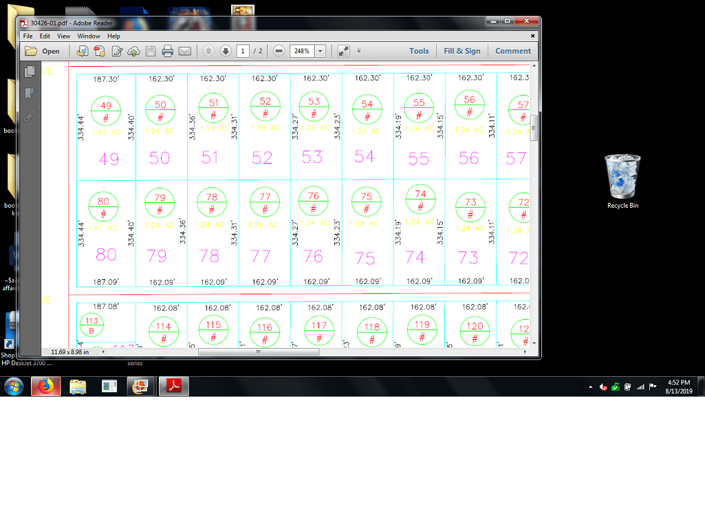
    I am having a boundary issue with my new neighbor. (Both literally and literally!) They decided to DIY their fence and used their survey map from 2001 to do it and survey the land themselves. When I brought up that there was a descprency, they refused to acknowledge it and put up the fence anyway’s. So here’s the descrepency. On the surveyor’s map, it show’s each parcel being the same exact size, 1.15 acres for all 4 parcels. Therefore his calculations were based on this size. Myself and the neighbor next to us have corner lots and the plat map say’s it’s 1.47 acres. The property behind us (and the neighbors deputing with us) owns a 1.2 acre parcel, which we ALL agree with the size, yet they refuse to acknowledge! Their fence has taken up almost a quarter of an acre. From what I read on the maps, in order to get an accurate calculation of the property, wouldn’t he have to figure out the difference between the 1.15 and 1.47 acres and then add this to the square footage? Did the surveyor screw up?  or did he just section it off and expect somebody else to calculate it? And what do I need to do to ensure we get a good one? Attached are both maps.  The plots are 49.50/80/79

    Your help is appreciated!

    thebionicman replied 4 years, 8 months ago 7 Members · 10 Replies
  • 10 Replies
  • dave-karoly

    dave-karoly

    Member
    August 14, 2019 at 12:42 am

    Can’t read the Surveyor’s map.

  • dave-karoly

    dave-karoly

    Member
    August 14, 2019 at 12:29 pm

    The survey is not calculated from the area on the tax map, that isn’t how it works. The tax map is meaningless here.

    Area is considered the least reliable element in determining a property boundary. The area will vary somewhat because measurements vary somewhat. The area is calculated by the Surveyor after the survey is completed, it is seldom a determining factor. There are other much more reliable elements such as stakes from the original survey and distances given by the original surveyor.

  • scott-ellis

    scott-ellis

    Member
    August 14, 2019 at 1:36 pm

    What Dave said about area is spot on, unless it is called out, an example I am selling you 2 acres out of my 5 acres then you get 2 acres. You seem to be in a platted subdivision, the original property corners is what you need for the boundary, or corners reset in the original location. Your lot is going to be the measurements on the subdivision plat. Sometimes on corner lots they include the area of the street in the lot, then when they widen the street they take that area away from the Lot.  Did the neighbor line up his new fence with an existing fence? If you want to dispute the new fence, you either need your Survey when you brought the Lot, or get a new Survey showing the lot boundary and, the location of the new fence. The only one answer based on what you have, is to hire a Surveyor to Survey your lot.

  • dmyhill

    dmyhill

    Member
    August 14, 2019 at 3:55 pm

    @angel722

    Surveyors love to dig into things. The amount of digging and comments you get will be directly related to the amount of information that you provide.

    If you want good comments:
    1. What state is this in?
    2. Show the whole survey. (There may be notes and other comments.) If you feel you need to redact names of the parties and the surveyor. If it is a public recording state, and it is a recorded survey, then shown the whole thing.

    This forum is a great place to get information, but priming the pump with enough information to start is very helpful.

    The map you “provided” shows acreage to =/- this indicates that the area is NOT what the surveyor started their calcs from.


    -All thoughts my own, except my typos and when I am wrong.
  • a-harris

    a-harris

    Member
    August 14, 2019 at 4:13 pm

    Area is the lowest on the priority of items used to restore monuments unless the deed called to be based on average.

    It can be used to determine what information on the drawing is incorrect.

    I’ve had to survey the entire block many times to reconstruct the boundaries of one property and use what correct information on the deeds and drawing to set monuments and mark boundaries.

    The rules to restore missing monuments in subdivisions and apparent simultaneous declarations is very clear as to do all that.

    When a subdivision is not recorded, you would probably need to go with junior and senior rights.

    It all depends upon what the deed says and how the property is described.

    0.02

  • angel722

    angel722

    Member
    August 14, 2019 at 4:55 pm

    I will contact the county and order the subdivision maps and the original one from here. We had planned on getting a surveyor to set the marker’s but this is like a nightmare 🙁 Thank you all for your time and information. I really appreciate it!

  • dave-karoly

    dave-karoly

    Member
    August 15, 2019 at 12:29 am

    The areas given on the tax map often don’t match what I would calculate from the subdivision Plat. The taxing authorities use some alchemy to determine taxable area which may include some of the street (usually the right of way line is some small distance into your front yard). The purpose of the tax map is so that the taxing authority can tax the Lot owner, they are not meant to be used for Surveying purposes.

  • RADAR

    RADAR

    Member
    August 15, 2019 at 2:34 pm

    @angel722

    look at the Assessor’s map for the disclaimer; they all have one:


    I hope everyone has a great day; I know I will!
  • angel722

    angel722

    Member
    August 15, 2019 at 4:04 pm

    But if their calculations are that off, wouldn’t that mean they are over taxing me? And how would the county come up with a number like that? The calculation on the tax map are more accurate with my acre parcel, where as their map seems to have taken away quite a bit of that acrage. The calculations are also not on the main road, but the neighbors survey map, he starts his calculations from the middle of the road. But then again, who know what it looked like in 2001,lol. A few feet, maybe, who cares, but the suryor’s map indictaes we all have the same acrage, which we don’t, so if his was accurate, he would screw ALL of us out of acrage. IDK. It just doesn’t make sense. We did have a stake closer to where the bounds show on the tax map but when they plowed and made a ditch, they somehow covered it. I have a deed but it is worthless until I can order the actual map from the county because on the deed it makes reference to where to find it, not what it is, which seems to be the same for all of us. The neighbor also DIY’ed his own boundary line according to his map calculations and he isn’t a licensed suryeyor. From what i read, there is still other calculations that need to be done to account for dips, slopes, ect, which the road is much higher then the property. So, this alone I know he screwed up. I appreciate all of your help!!

  • thebionicman

    thebionicman

    Member
    August 15, 2019 at 6:55 pm

    Angel,

    The purpose of a tax map is to depict how parcels are being taxed. That may or may not relate to a traditional understanding of ownership which may or may not relate to what you can occupy and use. Using information from the tax map to survey will almost always mislead you, even if the information on it is correct.

    Several people have talked about the ‘order of calls’, also known as ‘order of dignity’. This is s fancy name for ‘which parts of record information are considered best’. It’s s little more complex than that, because even higher ranked information is evaluated in light of the source. The tax map is pretty low as far as dources..

    Hope that helps, Tom 

Log in to reply.