

Ask A Surveyor
Public Group
Public Group
Active a week ago
If you are a landowner seeking advice from surveyors, please post your questions and issues here.... View more
Public Group
Organizer:
- Organized by
-
Group Description
If you are a landowner seeking advice from surveyors, please post your questions and issues here. DISCLAIMER: All surveying-related questions should be consulted with someone licensed in their jurisdiction and hired for professional services. The answers provided here are not to be construed as official advice from a professional that you would otherwise obtain in your local area.
Determining Finished Grade Plane Elevation Question!
Determining Finished Grade Plane Elevation Question!
Posted by MBaker1921 on February 20, 2023 at 5:08 pmHello:
I am from Duluth, MN and am confused on a survey done to determine established grade plane for 3 townhome structures. The purpose of the survey was to show that the first floor was a basement to allow the structures to stay within the IRC building code.
Attached are the survey and the builder’s plans for the structures(they are identical). Can someone please explain how the grade plane was determined based upon the survey….Thank you!
lurker replied 1 year, 2 months ago 6 Members · 10 Replies- 10 Replies

Standard stuff, the building is basically a walkout basement design, the front of the building is access into a basement garage.
Why is that an issue?

The notes on the Grade Line Exhibit (first attached PDF) are pretty clear about how the Grade Plane was calculated.
The surveyor could have computed all of that using 683.49 for the Finished Floor Elevation (likely from a local benchmark or another survey), or using 0.00 for the FFE. Or using -1000.00 feet for that matter.
It’s all relative, in other words. The actual elevation datum (reference elevation) is less important than how the surrounding terrain relates to the finished floor elevation.
“…people will come to love their oppression, to adore the technologies that undo their capacities to think.” -Neil Postman
Did you ask Scott Olsen?
NOTES:
1. SURFACE PROFILE REPRESENTS AS BUILT SURFACE ELEVATIONS ALONG A 6 FOOT OFFSET PERIMETER FROM BUILDING WITH EXCEPTION FOR WINDOW WELLS AND RETAINING WALLS.
2. CALCUALTED GRADE PLANE DETERMINED BY DIVIDING THE AREA UNDER THE SURFACE PROFILE AND DIVIDING BY THE LENGTH. AREA FOUND TO BE 996.956 SQUARE FEET. THE CALCULATED GRADE PLANE WAS FOUND TO BE 679.73 FEET, WHICH IS 0.33 FEET HIGHER THAN THE MINIMUM REQUIRED GRADE PLANE.
3. LICENSED LAND SURVEYOR IS CERTIFYING ONLY TO THE CALCULATED GRADE PLAN ELEVATION.
So it looks like Scott measured the surface elevations along a 6 foot offset perimeter of the building without regard for window wells and retaining walls. Then used that information to calculate the grade plane.
If you want to dispute the 0.33 feet (4 inches) higher than minimum required grade plane, you will probably need to higher another professional and see if they come up with different results. Or maybe hire a contractor to adjust the perimeter grade to meet the requirement.
 I hope everyone has a great day; I know I will!
@dougie I understand that and appreciate your response. I guess my question is how exactly a surveyor would “shoot” that to arrive at the result. In my experience, the finished grade plane elevation is simply measured at 8-10 places at 6′ out from the wall and the calculations done. I have not seem a grade plane elevation done using a surveyor. Thank you for any light you can shed.
Mark
I assuming Mr. Olsen is a licensed professional; he’s going to provide you with the most accurate information required. If you don’t think he provided that; you will need to bring a complaint. He shouldn’t be providing you false information, just because that’s what you want.
If you want to dispute the 0.33 feet (4 inches) higher than minimum required grade plane, you will probably need to higher another professional and see if they come up with different results. Or maybe hire a contractor to adjust the perimeter grade to meet the requirement.
Personally, I have an issue with requirements that say you must be above, below, or this far away from something a certain distance. How much of a tolerance do you read into it?
4″ isn’t much; you might find someone that might come up with a different number. Are you willing to pay for something that may not help your cause…
I hope everyone has a great day; I know I will!
@mbaker1921 A “shot” is when a surveyor uses his equipment to collect a point of data. Your surveyor collected data. He took measurements. He gave you his results. What about his methods do you not trust? What is it that you are suspicious about? The methods he used are his to determine and he is liable for the results he produced. Why are you questioning his methods? You show the results and seem to want to question the method based on the results. I don’t like that when it happens to me so I guess that is why I’m assuming you didn’t like the results and as a consequence are trying to find fault in the professional who produced those results.

The way I read it (and I may be wrong) is that there is a code or regulated standard that says that a basement is defined as having this specifically calculated grade plane elevation that’s at least 6′ below the floor above it. The calc itself is done by, as it says, taking an elevation profile along a 6′ offset from the face of the building, all the way around – that’s shown in both the profile views with the 12′ of space shown between each building face as expected – and then, with the low point of that profile being a reference or datum, calculating the area under the profile to that datum. That area is then averaged over the length of the profile (shown in gray) and it’s height is calced or measured. It may have been more clear if they had added the Y axis values (elevations beginning at the low point or ‘datum’) to the lower profile view. If they had it would be easier to see that the average “height” of that grade from datum (low point) is 4.33′ and would have also shown that his low point elevation along the profile (the datum) is 673.56.
Adding these to get the averaged elevation, you get the calculated grade plane elevation of 677.89 which is apparently 0.40′ higher than allowed to classify that floor as a basement.
I do also find that it could be confusing that they use the term “minimum grade plane”. I get that they may mean that it’s “at least” 6′ below the 2nd FFE (or, minimally 6′ below…), but when calling it an elevation I think it should read “maximum grade elevation” as in maximum elevation allowed.
But that’s either ‘just me’ or I’m missing something here.
What I might consider to rectify the situation is simply dropping the FFE by 1/2′, maybe just in the area of the garage. It’ll cost a little more grading and might goof with sheathing and framing a bit, but could be worth it. Never hurts to have a little higher garage ceiling height either because I almost always want to build some overhead storage there.
ddWhat I might consider to rectify the situation is simply dropping the FFE by 1/2′, maybe just in the area of the garage.
Correction: It looks like that in order to gain the average drop of 0.40′ you;d have to drop the pad of the garage area by about 12″-15″, not ½’. Might still be worth it.
dd@lurker Thank you for your response. The issue here relates to the developer and the Planning Department conspiring to allow these units to exceed the zoning for height in this district AND for the townhouse units to meet the Residential Building Code for a 3-story structure. There was extensive discussion between the developer and the building code people in the city as to how the grade elevation was to determined. The city did not want the developer to do it, but that is what happened(MSA Engineering) as indicated.
Anyway, I continue to be skeptical for the following reasons:
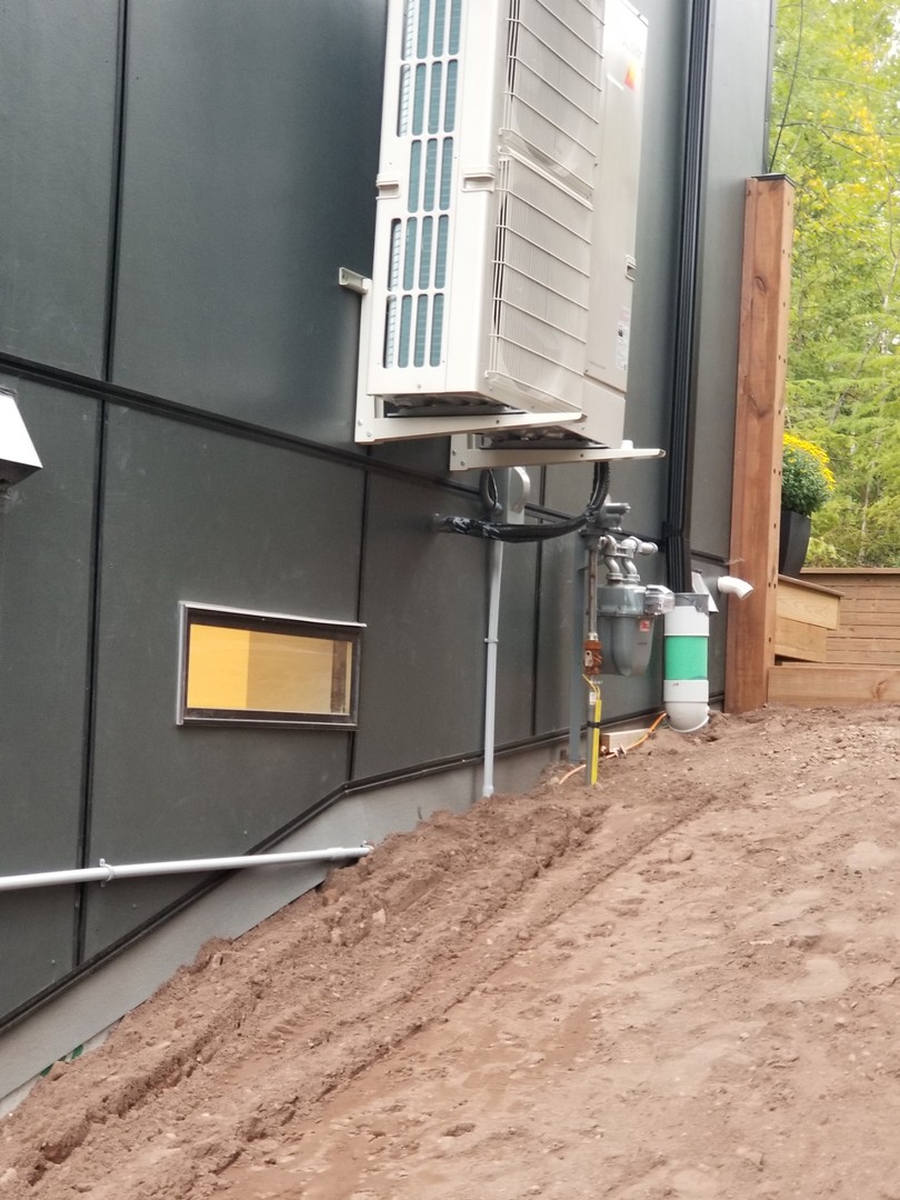
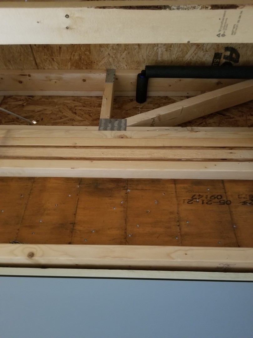
1. The height of the finished floor above is purported to be 9’4″. I have not measured this but I did take some pictures during construction. This is circled in red. The first pic attached shows the header above a 7″ door to the garage. It appears to me to be more than 2′ 4″ to the finished floor above. Wouldn’t you agree?
2. The grade plane is marked by a dashed line on the survey. It is shown as a red circle on the survey. It does not represent reality.
3. Attached is a picture of one of the sides of the 3705 unit showing the actual finished grade. This is also circled in red on the survey. This is totally inconsistent with where the survey drawing of the where the grade elevation is.
4. Do the calculations as indicated on the survey. They actually show the grade plane to be more in compliance than shown on the survey. This does not make sense to me.
I would appreciate your input. Thank you!!

I can’t say anything is wrong or right based on your pictures. The finished floor elevation is not subjective. There is no need to guess at it from looking at a picture. It is easily measurable. Highly unlikely someone would attempt to commit fraud by falsifying finished floor elevations since they are so easy to determine. If what you believe is true, then you can easily prove that the finished floor elevations have been falsified and perhaps your conspiracy theory is true.
I don’t understand how the grade plane doesn’t represent reality. Help me out, where is the dirt in the picture relative to the building? How are you relating the vertical position of the dashed line to a vertical element of the building. I couldn’t tell you if the dirt was a foot too high or a foot too low based on the photo you posted. Again it is easy to make the measurements. If you want to fight it get some objective data. Trying to interpret pictures is folly. Collect the data and prove they are conspiring together to allow these units to exceed the zoning height.


Log in to reply.