

Ask A Surveyor
Public Group
Public Group
Active a week ago
If you are a landowner seeking advice from surveyors, please post your questions and issues here.... View more
Public Group
Organizer:
- Organized by
-
Group Description
If you are a landowner seeking advice from surveyors, please post your questions and issues here. DISCLAIMER: All surveying-related questions should be consulted with someone licensed in their jurisdiction and hired for professional services. The answers provided here are not to be construed as official advice from a professional that you would otherwise obtain in your local area.
Coordinate System
Coordinate System
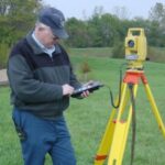
Posted by mercer on March 13, 2023 at 9:05 pmHi guys, so i’m very new to surveying. I recently purchased a sokkia GRX2 base and rover system, and i’m using fieldgenius software. I’m having trouble finding what coordinate system I should be using. I set up the base and used an averaged position to find its location. The northing was almost right on what it should be, however the easting was off by over 40,000 meters. I have a known point on my property, and that is what i’m comparing the numbers to. I live in St. John’s, Newfoundland, Canada. Any help would be greatly appreciated.
Thanks
lurker replied 1 year, 1 month ago 20 Members · 40 Replies- 40 Replies

You need to figure out what coordinate system and datum your “known” values are in.
I’m not very familiar with Canadian systems, but I know they have a realization of NAD83 many users work in the UTM coordinate system.
.
What’s your background? What are you looking to do with your new gear?
“…people will come to love their oppression, to adore the technologies that undo their capacities to think.” -Neil Postman
Is there a UTM zone? Here in Ontario, we use the same NAD83 CSRS, but it’s UTM 18N.

Site calibration/localization. Done. What could go wrong?

When you say an averaged coordinate, are you saying you set up the base on a point and clicked “here”? Also, are you set up for running static?
It’s almost impossible to give a single answer to “what coordinate system should I use” because there are virtually endless systems that could be used for a project.
I hear UTM is common in Canada, but you will have to select the correct zone depending on where you are working.
Some jobs may cross the border between two zones, but will use one or the other.
Some jobs may have a custom projection, which you will need to enter into your software to properly run GNSS.
Some jobs may use a conversion to go from “grid to ground”, which involves applying a scale factor to observed coordinates on the fly.
Some jobs may have no projection or relationship at all to the geodetic ECEF system that your new GNSS system operates in “under the hood”. For those you would have to compute a transformation in the field, or build a custom projection yourself.
If you’re not going to be doing any formal training and are still set on using the gear, I highly recommend reading some books on projections and geodesy.
Don’t forget that the vertical component can be tricky as well since GNSS observations rely upon a geoid model to properly transform ellipsoid heights to orthometric heights.
“…people will come to love their oppression, to adore the technologies that undo their capacities to think.” -Neil PostmanIs this SurveyorConnect? or ContractorConnect, or GIS-Connect, or “I-Have-A-Paving-Company-Connect”?
If folks/businesses are going to purchase the gear and not employ someone proficient to use it properly, OR get the training they need to be proficient, then they deserve to fail.
Fail miserably, publicly, and so badly their company goes out of business.
Wreckless behavior should be eliminated and not encouraged.
Contributions to this social media platform should not enable the negligence of others.

Contributions to this social media platform should not enable the negligence of others.
You mean like a sizable percentage of advice provided on this site?
A social media platform with a considerable number of licensed professionals willing to hand out advice seems like a great target for lawsuits.
Terms of Service be damned.
How long/likely do you think it is before a negligence suit is brought against one of these People?
Don’t think for one minute attorneys aren’t looking for another party with $$$.
Next, Wendell gets a subpoena from “People’s Attorney(ies) for all the information for every User on the thread where People solicited advice, and received advice on how to proceed, etc?
Then, whether merit or not, all involved get named in the suit.
Would that be covered by your insurance? Would your license be at risk? Would a complaint be warranted?
Yeah, like that.

You might want to consider taking some formal training. It’s sort of a recipe for disaster if you don’t understand the various projections you would be working with and how to move between them or create your own when it’s more appropriate.
Not to make light but it kind of reminds me of someone trying to learn to drive through an internet forum. This driver-ed teacher was telling me about this woman fresh off the boat from China he was tasked with teaching how to drive and all she had ever ridden was a bicycle. Every time it came time for her to make a turn she would lean over into the curve but turning the steering wheel was completely lost on her.
Good luck.
WillyI certainly agree with the sentiment. As of right now the likes of Wendell is protected by Section 230, though. Individual posters? I’m not a legal expert- don’t ask me.
I digress. My jab was less at your train of logic and moreso a borderline hijack with ensuing rant. But I’ve had my coffee, so I don’t think we’ll be going there.

Youtube & home improvement shows have a way of making things worse before being forced to do things right.

The projection you will want to use will be the same one the design is done on, and it might very well change from job to job. In my area there are three reasonable choices available. Your area probably has a similar number.
I expect that you will eventually come to realize that the surveyor fees you have been paying has been money well spent.
The given coordinates indeed look like UTM and the northing seems to fit Goulds (assuming zone 22T), but I also find about 44 km difference between those values and a point on Lakeview Dr in Goulds.
Your upload cuts off the identification of the station. Knowing it might help us understand the situation.
I tried the Natural Resources Canada site but was not able to locate a station at either location. I’m not familiar with the Canadian network, so might not have done it right. CBN would be Canadian Base Network, similar to US FBN stations.
Is there another point you can check? It would be rare, but was there a copying error in getting those given values?
Once you get in the ballpark, there may be slight differences between version 6 and v7 coordinates and you should understand the difference before relying on the data.
.
I suggest you check the Association of Newfoundland Land Surveyors website for a local professional. You may find that the construction plans you are supplied have been based on work by one if these professionals.
As has been noted there are numerous coordinate systems that may be used. Checking with the surveyor that did the initial development/planning survey is always the best course.

Sorry for asking guys, I forgot everyone here was born with endless knowledge about everything. My mistake.
Let me put this in context, similar to what you asked:
My neighbor has a paved driveway.
He’s a dentist.
He bought a paving machine, but can’t figure out how to start it.
Does that mean he should run a paving company?
@michigan-left I’m not looking to start a surveying company. My only intent is to facilitate construction layout via use of the equipment we have available. Unlike you, I’m not afraid to take on new challenges, and in turn learn new things. Many construction companies do their own layouts, at least in my neck of the woods. And furthermore, I was not, and will never look to seek your approval.

Log in to reply.