

Ask A Surveyor
Public Group
Public Group
Active a day ago
If you are a landowner seeking advice from surveyors, please post your questions and issues here.... View more
Public Group
Organizer:
- Organized by
-
Group Description
If you are a landowner seeking advice from surveyors, please post your questions and issues here. DISCLAIMER: All surveying-related questions should be consulted with someone licensed in their jurisdiction and hired for professional services. The answers provided here are not to be construed as official advice from a professional that you would otherwise obtain in your local area.
Avoiding conflict between the symbol sets N + H + h and E + N
Avoiding conflict between the symbol sets N + H + h and E + N
Posted by terminologist on August 27, 2023 at 10:18 amAs I continue my research to produce a term bank for the surveying field, I have noticed an obvious conflict when using the following symbol sets in the same text:
- N + H + h for heights
- E + N for plane coordinates
What solutions can be used to avoid this? Do we ever see z with subscript letters to indicate the three types of height? Is it sensible to borrow x + y from the Cartesian coordinate system, as I have seen in some projects, for northings and eastings?
Thanks for your thoughts.
mathteacher replied 7 months, 4 weeks ago 7 Members · 9 Replies- 9 Replies

This question reminds me of one of my geodesy classes in college. The professor was whipping equations up on the blackboard, and I interrupted him to ask “What does that gamma symbol represent.” He replied, “That’s the ___.” I said, “but yesterday, you used the alpha symbol for that.” He replied, “it doesn’t matter what symbol we use, so long as you understand the equation…”

There are maybe 100 symbols that are easily distinguishable in equations. Roman alphabet, greek alphabet, a few math operations, a few from other alphabets.
There are far more parameters to be studied in the sciences. Subscripts help, but each symbol must do multiple duty.
As one studies a subject from various perspectives, usages from one area tend to conflict with usages from another area. Dealing with this is just part of the scientific landscape.
.
Context has to be the guide for your two bullet points. As to the two N’s, the difference in magnitude between two uses should eliminate errors caused by confusion.
For the second case, consider whether xyz or ENU is preferable. Note the following output from NGS INVERS3D for mark EZ4026 where only the elllipsoid height (h) is changed for the distance calculation. Note the use of capital letters for coordinates and that all three coordinates changed when only the input heights were different. To me, that’s an argument against using z to represent only height.
First Station : Lucy
—————-
X = 904826.8272 m LAT = 35 59 49.32932 North
Y = -5086521.0275 m LON = 79 54 47.97531 West
Z = 3728056.8618 m EHT = 223.3450 Meters
Second Station :
—————-
X = 904837.6888 m LAT = 35 59 49.32932 North
Y = -5086582.0864 m LON = 79 54 47.97531 West
Z = 3728101.9153 m EHT = 300.0000 Meters
Forward azimuth FAZ = 0 0 0.0000 From North
Back azimuth BAZ = 0 0 0.0000 From North
Ellipsoidal distance S = 0.0000 m
Delta height dh = 76.6550 m
Mark-to-mark distance D = 76.6550 m
DX = 10.8616 m DN = 0.0000 m
DY = -61.0590 m DE = 0.0000 m
DZ = 45.0535 m DU = 76.6550 m
Carry on, resist the temptation to be an agent of change, and best wishes for success.

I cannot understand how anyone can confuse the two types of “N” you mention.
The geoid is the fundamental surface of physical geodesy. When used in height determination we have the relationship:
h – H – N = 0 (plus errors)
H refers to an orthometric height which is the distance along the curved plumb line from the geoid to the point of interest.
h refers to an ellipsoid height which is the distance from the ellipsoid surface to the point of interest.
N refers to the separation between the ellipsoid height and geoid surface. The geoid lies below the ellipsoid in the lower 48 US states.
The geoid surface undulates about the elllipsoid with separation about +/- 100 meters.
The “N” designating NORTHING is only meaningful as part of a coordinate pair with E designating EASTING
As MathTeacher states, context is key.
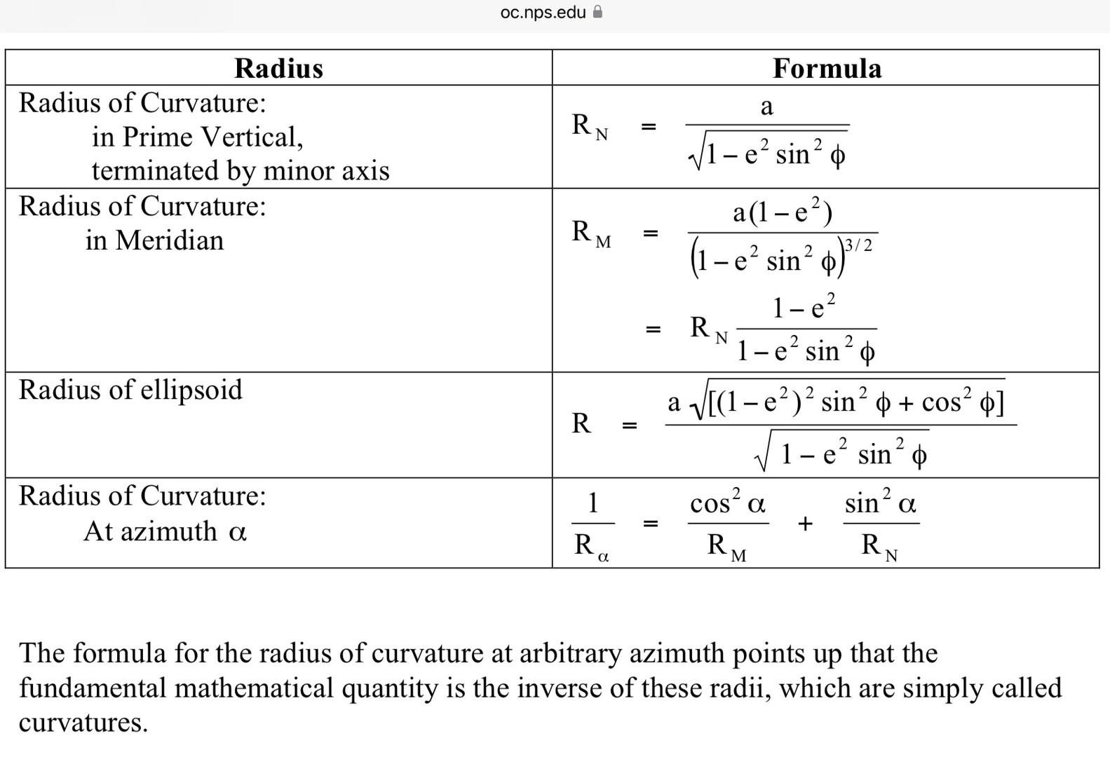
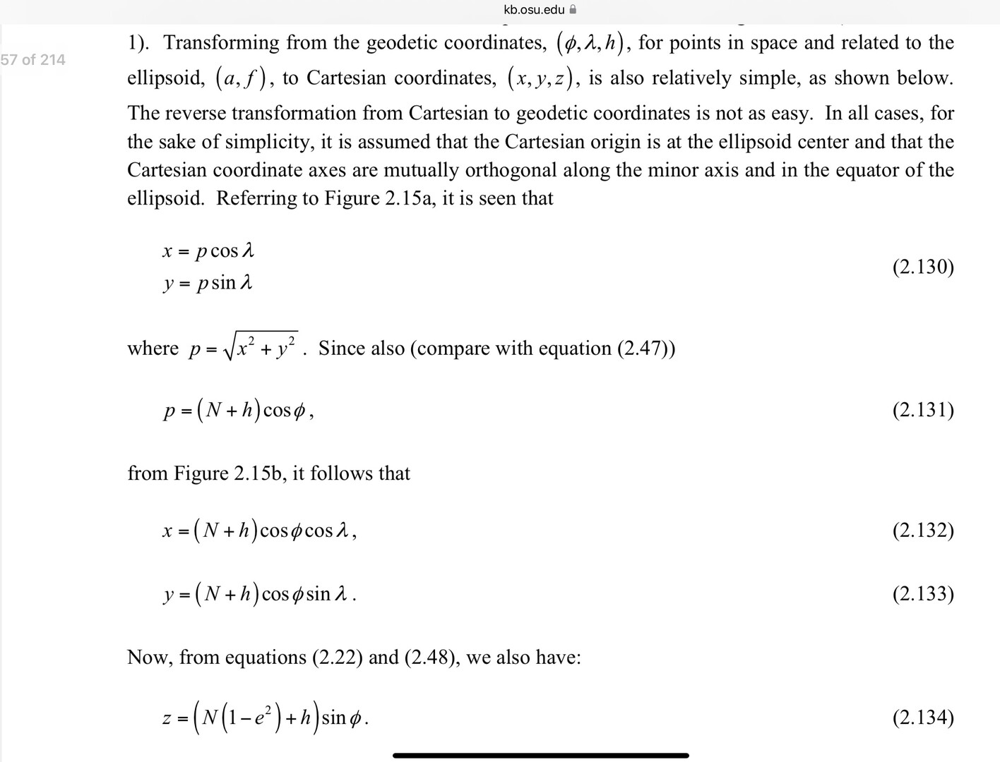
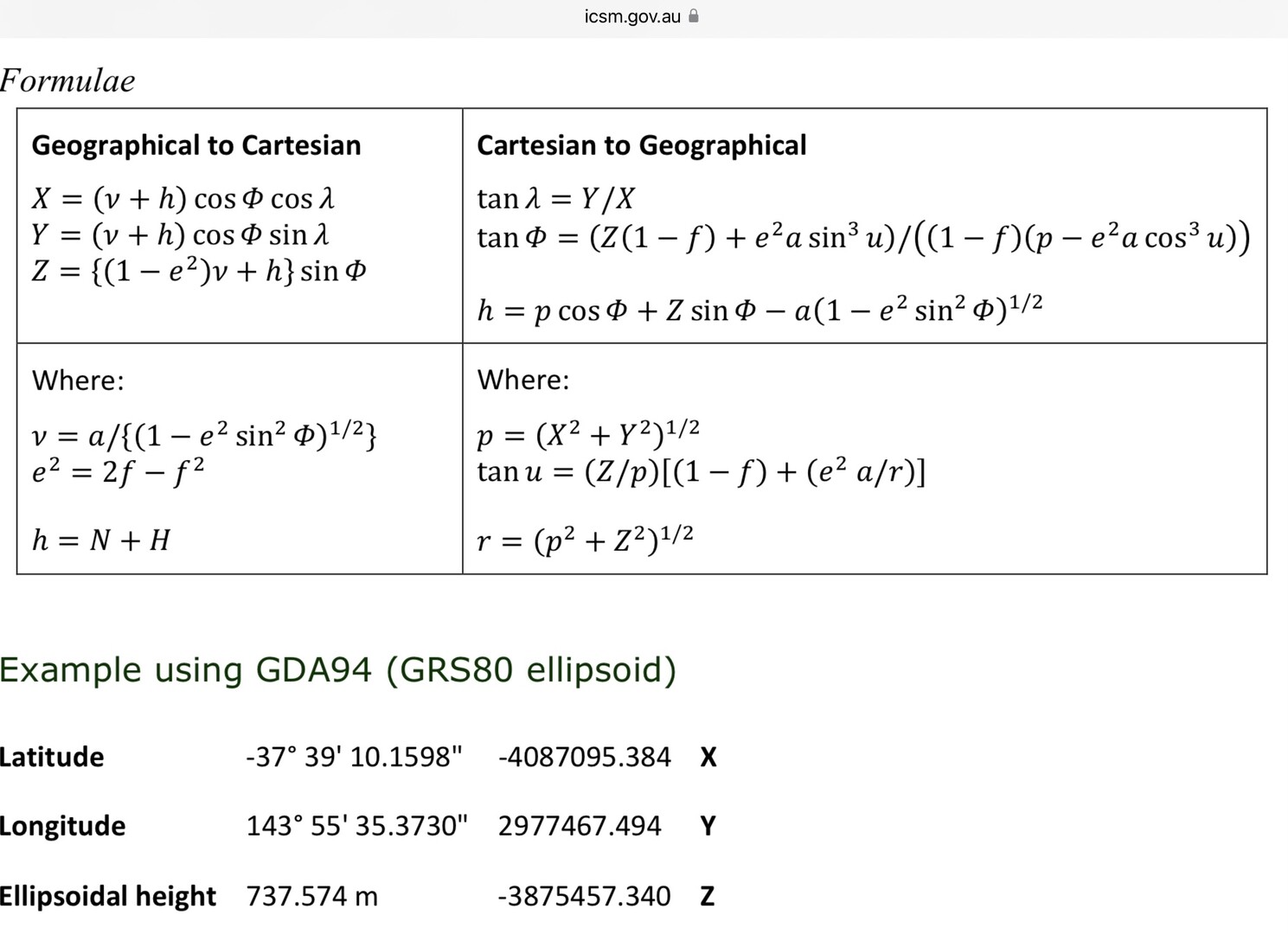
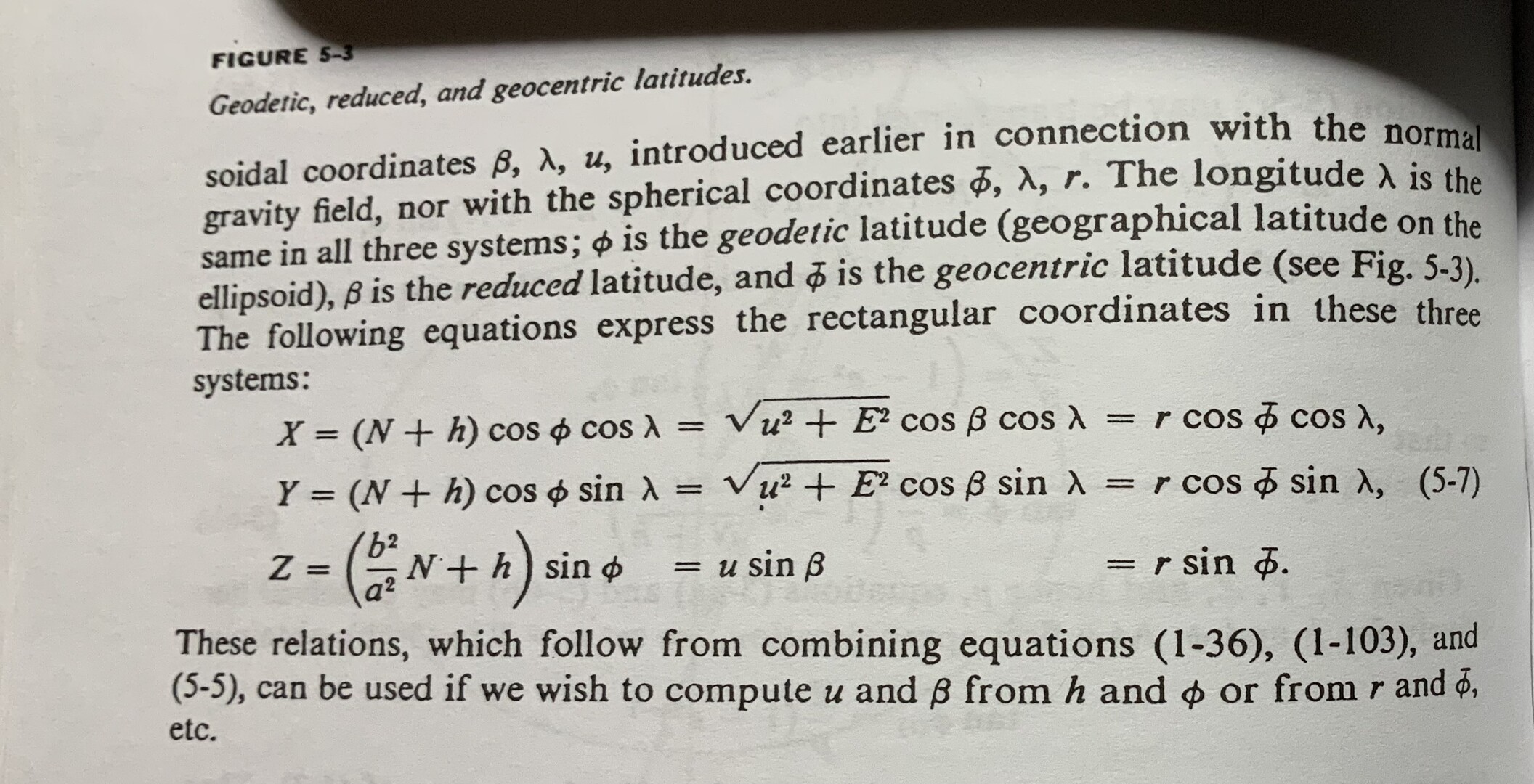
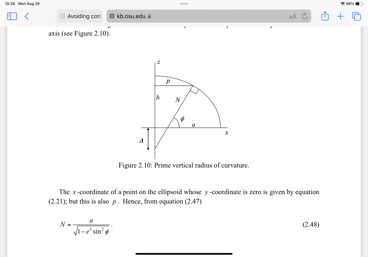
BTW, There is another use of N in geodesy. It is the radius of curvature in the Prime Vertical. It is used in the transformation of Latitude, Longitude and ellipsoid height to XYZ (ECEF).
In practice some entities use alternates to N. The Australians use “v” see: https://www.icsm.gov.au/sites/default/files/2017-09/gda-v_2.4_0.pdf#page43
Others use “Rn” and “Rm” for prime vertical and meridian, respectively.
At “The OSU” Jekeli’s “Geometric Reference Systems in Geodesy” (2016) available as a PDF uses N. See:
https://kb.osu.edu/bitstream/handle/1811/77986/Geom_Ref_Sys_Geodesy_2016.pdf
Some screen captures follow:
The photo is from “Physical Geodesy” by Heiskanen and Moritz (2000).
In addition to MathTeacher’s statement, I urge data users to document the values they store and supply.
Hope this contributes
DMM

@mathteacher I have to disagree with your argument that the order of magnitude would suffice to distinguish N referring to the geoid-ellipsoid separation and N referring to a northing. Surely both could be in the order of 100m at a point close to the zero-northing axis?
All state plane and most if not all LDP systems are designed so that the coordinate values in the area they are intended to cover are multi-digit numbers. Even local project coordinate systems are usually designed that way.
And the pairing of east and north values, as indicated by others, prevents ambiguity.
.
Surely both could be in the order of 100m at a point close to the zero-northing axis?
I’m almost certain that there is not in any state, a state plane coordinate value in the order of 100m. Zilch, zero, nada.
The location of said coordinate in the state’s plane coordinates would actually plot in a different state.

Not to mention that the range of values for the current geoid (at least in CONUS) is around -50m to +3m. I don’t think that’s going to change by a whole lot when the new geoid is released.
“…people will come to love their oppression, to adore the technologies that undo their capacities to think.” -Neil PostmanHave you seen a case where someone actually confused these upper-case N’s? Here’s a quote from https://www.ngs.noaa.gov/GEOID/
“The National Geodetic Survey has released updated models for transforming heights between ellipsoidal coordinates and physical height systems that relate to water flow.”
Note the purpose of geoid models.
In plane coordinate systems, the only height that’s relevant is the ellipsoid height, or h. Thus, N as a height variable shouldn’t be a concern.
I’m really curious about how and under what circumstances any confusion has come up.


Log in to reply.