

Ask A Surveyor
Public Group
Public Group
Active a week ago
If you are a landowner seeking advice from surveyors, please post your questions and issues here.... View more
Public Group
Organizer:
- Organized by
-
Group Description
If you are a landowner seeking advice from surveyors, please post your questions and issues here. DISCLAIMER: All surveying-related questions should be consulted with someone licensed in their jurisdiction and hired for professional services. The answers provided here are not to be construed as official advice from a professional that you would otherwise obtain in your local area.
Are eastings/northings values or lines?
Are eastings/northings values or lines?
mathteacher replied 9 months, 1 week ago 19 Members · 64 Replies

Coordinates expressed as northings (N) and eastings (E) define the location of a point in a 2D-rectilinear system derived from ellipsoidal latitudes and longitudes via projection parametersparticular to its politically-defined location. Points expressed as N and E values are not linked to the geocenter.
The relationship between any two points in a rectilinear system can be derived through plane trigonometry.
In the US the main implementation of rectangular coordinate systems is the State Plane Coordinate System. Prior to the adoption of the North American Datum of 1983, the National Geodetic Datum of 1927 expressed SPCS coordinates as X and Y values.
Please note that a 3-dimensional coordinate systems have been developed to express latitude, longitude and ellipsoid height values (for a point or a vector) in terms X,Y,Z (earth-centered earth-fixed) with their values being with respect to geocenter. Local Geodetic Horizon coordinates expressed in North, East and Up can be derived from known latitudes and longitudes plus XYZ coordinates using rotation matrices.
Over-explaining as usual… To damned hot to get out of the house.
You are assuming to much, northerings and eating don’t necessarily have any particular relationship to “ellipsoidal latitudes and longitudes (derived) via projection parameters.
@field-dog I never understood surveyors’ aversion to negative numbers.

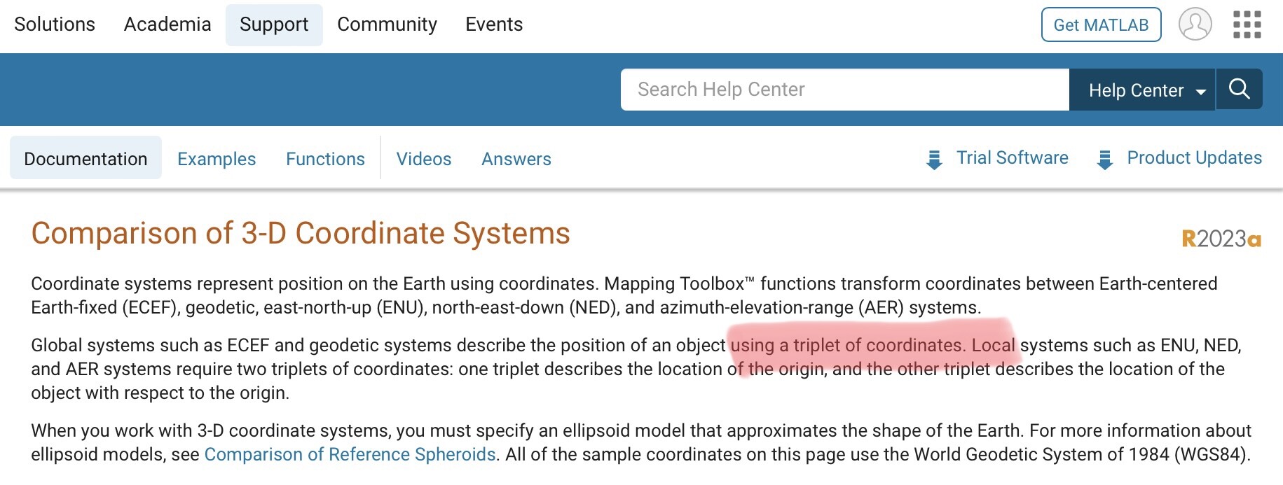
The image above is from the Mathworks site. When dealing with different types of dimensional data “we” would refer to coordinate pairs or coordinate triplets.
Personally, with the advent of technologies allowing three-dimensional positioning (even before GPS), I cannot see why users continue to use 2D systems like the SPCS.
See Burkholder’s The 3D Global Spatial Data Model.

@native1 You are wrong. I am sat here drinking a pot of coffee.
@thebionicman I would argue that a northing or easting could be stated in isolation, but it is nonetheless inherently part of a system of coordinates.
An analogy would be describing the individual deeds of a ‘conspirator’ (and not a ‘spirator’), who by definition forms part of a group.

I’m not sure of the purpose your project is intended to serve, but that’s a good first draft. Here are two thoughts:
An easting/northing is the plane equivalent of a latitude/longitude: each is a coordinate, which amounts to a value in terms of a distance or angle respectively, in the set of coordinates that their coordinate system specifies.
Yes, a coordinate is a distance and an angle, but you omitted a key element. The distance and angle are from the origin of the coordinate system. In a sense, you are mixing two representations: rectangular and polar coordinates. That’s not necessarily bad depending on your purpose and your audience, but the wording and the concepts it represents deserves some careful thought.
… we could say that a north-south line has the same easting value.
This one trips up many people. Let me give you an example using UTM Zone 17 coordinates.
Latitude = 36.0; Northing = 3,984,064 meters
Longitide = -81.5; Easting = 453,936 meters
Keeping Longitude constant at -81.5 and moving north b 1/2 degree:
Latitude = 36.5; Northing = 4,038,524 meters
Longitude = -81.5; Easting = 455,222 meters
Note that in moving due north; ie, keeping longitude constant, the Easting changed by roughly 1,300 meters.
Thus, a north-south line on an ellipsoidal representation of the earth does not produce a line with constant Easting on a map. There’s a lot of mathematics that explains this characteristic, but the one that you should explore is the convergence of the meridians.
You can explore this relationship further here: NGS Coordinate Conversion and Transformation Tool (NCAT) (noaa.gov)
You’re on a good track, just don’t ignore the details.

@terminologist The logic may loosely apply, but the words ‘ordinate’ and ‘coordinate’ have edtablished and distinct meanings. An ordinate is a line, plane, or axis. A coordinate is the point where two or more of these intersect or interact in a way that defines a specific point.
I am unfamiliar with your definition of ordinate.
I do not see it as consistent with that in the NGS Geodetic Glossary (located here: https://www.ngs.noaa.gov/CORS-Proxy/Glossary/xml/NGS_Glossary.xml )
Some screen captures regarding coordinates and ordinates from that source follow:

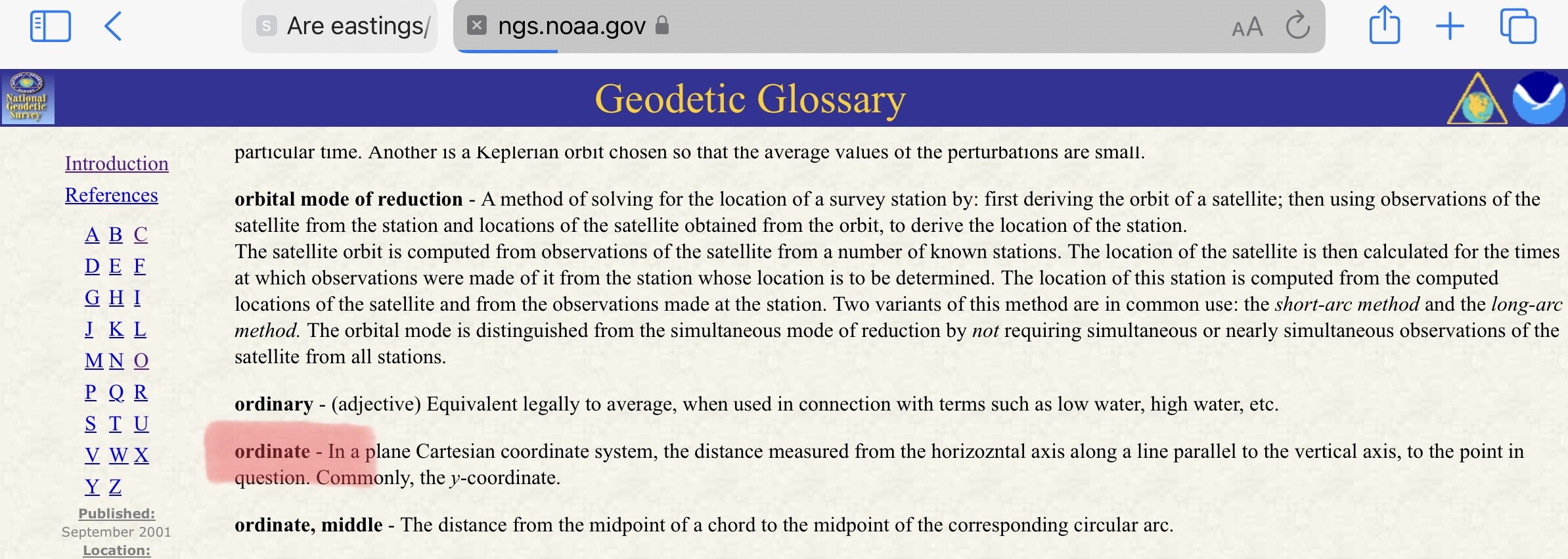

The last image above is from the Cambridge on-line dictionary. This is the sense I remember an ordinate being defined.
Defining a point via a northing and easting raises the question with respect to what?
I do not understand the comment posted by @aliquot which I read to indicate that plane coordinates are not necessarily linked to the underlying ellipsoidal coordinates i.e. latitude and longitude. Is that what you (@aliquot) are saying? If so, they would be equivalent to “assumed” coordinates.
The spelling and definition of ordinate have been fairly consistent back to new latin. I did expand on the dictionary definition to include other types of coordinates that surveyors deal with.

@geeoddmike sounds like you are thinking of “assumed north”. There are an infinite number of ways of assigning coordinates to a point. US Surveyors often use State Plane, others use equivalent systems, or UTM derived systems which are related to the elipsoid, but surveors were using coordinates long before these were invented.
All that is required is to pick an origin and chose how to define north and you have a coordinate system.
I beg to differ. The Cartesian coordinate system was first presented by Rene Descartes in 1637. In the coordinate pair (x, y), the value of y is the ordinate and the value of x is the abscissa. Descartes’ terms in French were applicata and ordonnees which translate to abscissa and ordinate in English.
In a typical geodetic plane coordinate system, North is the y-axis and East is the x-axis. Thus a coordinate pair is (E, N), E is the abscissa and N is the ordinate. (We really should say Eastings and Northings instead of the other way round.)
In early NGS papers, and in some surveying software today, x and y were and are used instead of E and N.
Now whether Decartes stole the Cartesian coordinate system from surveyors or whether surveyors adopted the system from Decartes may be open to investigation.
The abscissa is a specific type of ordinate, the same as a height.
I’m just repeating what the man who invented the system said.
But to get really fundamental, a plane cartesian system is created by the intersection of two number lines in a right angle. Every point on any number line is a coordinate. For example:
|———|———|———|—–>
0 1 2 3
the points on the number line are coordinates. Thus, 1 is a coordinate, 2 is a coordinate, and 3 is a coordinate. All of the points both between and beyond the marked ones, both rational and irrational, are coordinates as well.
Note that there’s only one number associated with each coordinate.
When a vertical number is added to create the Cartesian plane, the points on the vertical line are also coordinates, but now coordinates on both lines contain two numbers. The coordinate 2 on the horizontal line is now (2, 0), but it’s still a coordinate.
Adding a third number line perpendicular to each of the first two creates a 3-dimensional system, but the points on that third line are also coordinates. In that system, the coordinate of the 2 on the horizontal line is (2, 0, 0).
So, just as it is correct to say the x-coordinate, which is just the distance from the vertical number line to the point, it is also correct to say the Northing-coordinate.

5000,5000,100
Yea, that backsight looks to be about N45°W !

The Cartesian coordinate system was first presented by Rene Descartes in 1637.
You’ve piqued my interest. Was Descartes development his alone, or is it like much of the Renaissance period before Descartes, a rediscovery of Greek math principals?
I haven’t had time to research it so I figured you can be Wikipedia for me.
The pre-Descartes history is sketchy but there were apparently forerunners, or at least giants on whose shoulders Decartes could have stood.
The old story is that Decartes was lying in bed watching a fly crawl on the wall when he thought of a way to represent the fly’s position on the wall using the four corners of the room for reference.
An old British encyclopedia of mathematics that I have says that Decartes’ original system did not employ two axes and that the system was actually refined into usability by Gauss and others.
I also looked at archaelogical grid history and found that their first documented use was in the 1920s. That’s interesting since it roughly corresponds to the map projections that later became state plane systems.
I’m fascinated by how different professions modify the same concept for use in their work. Surveyors calculate angles (azimuths) from the y-axis while mathematicians calculate angles (slopes) from the x-axis. Surveyors find it useful to confine their coordinate systems to Quadrant I while mathematicians find value in using all 4 Quadrants.
But the theoretical foundations of the concepts remain the same.
@mathteacher Your first example is of a single line. The other ‘ordinate’ is the value of the baseline, presumably zero.
The concept of ordinates (and the term) date to at least the late 14th century. I suspect the concept was understood long before that, but Descartes was a latecomer discoverer. He absolutely was the earliest widely know publisher, but the concept was there and in use long before he came along.
My apologies for the THRAC, I recognize I occasionally get hung up on things like this. I’d like to say that will change, but it’s unlikely..
I certainly won’t argue the history; that’s for academicians. Undoubtedly there were earlier forms and the coordinate plane was not complete until Gaus and Fermat added their contributions.
But let me ask you this: Ia (10000, 10000) the coordinates of a point or the coordinate of a point? If you answer the fromer, why is the word plural?


Log in to reply.