

Ask A Surveyor
Public Group
Public Group
Active a day ago
If you are a landowner seeking advice from surveyors, please post your questions and issues here.... View more
Public Group
Organizer:
- Organized by
-
Group Description
If you are a landowner seeking advice from surveyors, please post your questions and issues here. DISCLAIMER: All surveying-related questions should be consulted with someone licensed in their jurisdiction and hired for professional services. The answers provided here are not to be construed as official advice from a professional that you would otherwise obtain in your local area.
Are eastings/northings values or lines?
Are eastings/northings values or lines?
Posted by terminologist on July 24, 2023 at 4:25 pmDear Surveyors,
I am a terminologist working on an information management project that involves defining some complex concepts, and I would appreciate your expert input. This is my understand so far, with some key concepts in italics:
An easting/northing is the plane equivalent of a latitude/longitude: each is a coordinate, which amounts to a value in terms of a distance or angle respectively, in the set of coordinates that their coordinate system specifies. Just as a latitude/longitude is not considered a line, an easting/northing is not a line either. However, just as we can say that a parallel/meridian is a line with a particular latitude/longitude, we could say that a north-south line has the same easting value.
Does anything seem grossly incorrect in the above paragraph?
I appreciate your help.
mathteacher replied 8 months, 3 weeks ago 19 Members · 64 Replies- 64 Replies

a distance or angle
a distance from an axis of the coordinate system.
I don’t see that an angle has any need to be mentioned in that sentence.
The whole paragraph seems clumsy. In that i see no need to argue about lines at all.
.
Meridians are lines with the same Longitude, not the same Latitude/Longitude. That is a point not a line.

Northings and eastings are values that communicate distance from their respective reference axes.
Latitudes and longitudes are values as well, but they communicate angles from their respective reference planes.
Just as one latitude value and one longitude value taken together (pair of coordinates) communicate a single point on a sphere or an ellipsoid, one easting value and one northing value taken together (pair of coordinates) communicate a single point on a plane.
In that sense they are equivalent in that a coordinate pair defines a single point.
Beyond that, I would think that discussion of lines would need to be its own section…planar lines are pretty simple but when discussing spheres or ellipsoids there’s a need to discuss geodesics, rhumb/loxodromes, great circles, etc…
“…people will come to love their oppression, to adore the technologies that undo their capacities to think.” -Neil Postman
just as we can say that a parallel/meridian is a line with a particular latitude/longitude
What you have written is OK, notwithstanding some esoteric trivia. I’d amend the line above just slightly, for clarity, as follows:
just as we can say that a parallel or a meridian is a line with a particular latitude or longitude

There are all sorts of coordinate systems. My Northing and Eastings may or may not result in true (whatever that means to you) North – South directions on the globe.
I see what is being attempted, but if someone understands projections (which if you have eastings and northings, then you have a projection of some sort, I would guess) then they should already know what the paragraph states.
-All thoughts my own, except my typos and when I am wrong.
Dear Surveyors,
I am a terminologist working on an information management project that involves defining some complex concepts, and I would appreciate your expert input. This is my understand so far, with some key concepts in italics:
An easting/northing is the plane equivalent of a latitude/longitude: each is a coordinate, which amounts to a value in terms of a distance or angle respectively, in the set of coordinates that their coordinate system specifies. Just as a latitude/longitude is not considered a line, an easting/northing is not a line either. However, just as we can say that a parallel/meridian is a line with a particular latitude/longitude, we could say that a north-south line has the same easting value.
Does anything seem grossly incorrect in the above paragraph?
I appreciate your help.
HI
those terms already defined in the NSPS Definitions of Surveying. Why add to the confusion?

Coordinates expressed as northings (N) and eastings (E) define the location of a point in a 2D-rectilinear system derived from ellipsoidal latitudes and longitudes via projection parameters particular to its politically-defined location. Points expressed as N and E values are not linked to the geocenter.
The relationship between any two points in a rectilinear system can be derived through plane trigonometry.
In the US the main implementation of rectangular coordinate systems is the State Plane Coordinate System. Prior to the adoption of the North American Datum of 1983, the National Geodetic Datum of 1927 expressed SPCS coordinates as X and Y values.
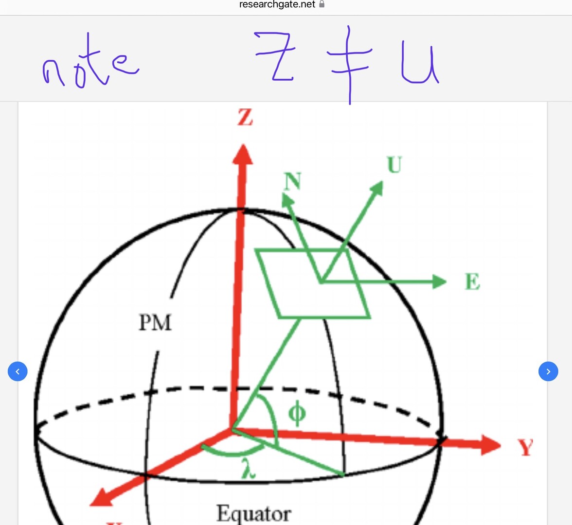
Please note that a 3-dimensional coordinate systems have been developed to express latitude, longitude and ellipsoid height values (for a point or a vector) in terms X,Y,Z (earth-centered earth-fixed) with their values being with respect to geocenter. Local Geodetic Horizon coordinates expressed in North, East and Up can be derived from known latitudes and longitudes plus XYZ coordinates using rotation matrices.
Over-explaining as usual… To damned hot to get out of the house.
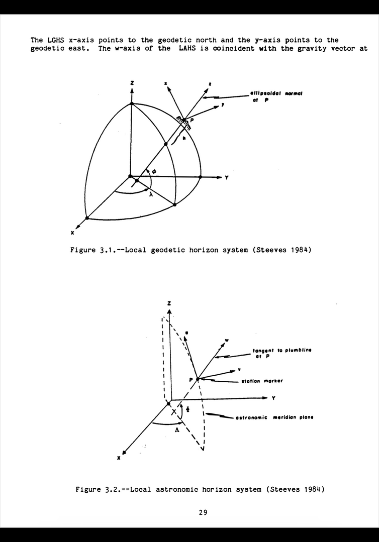
LAH and LGH copied from NGS TM 47 describing design and use of the NGS program ADJUST by D Milbert and W Kass (1987).
https://geodesy.noaa.gov/library/pdfs/NOAA_TM_NOS_NGS_0047.pdf
As usual, a picture is worth a thousand words…
I think folks are getting hung up on the projection piece.
I could be wrong, but based on the OP, it doesn’t seem like there is a need to explain or discuss projections, distortion, ECEF, etc., just the bare essentials of what northings and eastings are, and how they are similar to latitude/longitude, as an aid for users reading about the term.
“…people will come to love their oppression, to adore the technologies that undo their capacities to think.” -Neil PostmanI think folks are getting hung up on the projection piece.
We NEVER get hung up on this sort of thing!
-All thoughts my own, except my typos and when I am wrong.
Northings and Eastings; Latitudes and Longitudes, by themselves, are lines. When used together, they are points.
A simple grid is a good example. X and Y are the lines forming the graph. X,Y are the points of intersections.
 I hope everyone has a great day; I know I will!
Thank you all for your help so far. I have incorporated your input into the project.

Northings and eastings are values that communicate distance from their respective reference axes.
Also, as far as I know, nobody uses negative values.
MHwhich amounts to a value in terms of a distance or angle respectively
Using a set of two northings and eastings, a distance and a direction. Using a set of three, an angle.
MH
Northings, eastings, and heights are not coordinates, they are ordinates. When ordinates are paired they become COordinates…
Trivia note… For some of us, hearing “north coordinate” can induce stress resulting in a mild stroke ..

Northings, eastings, and heights are not coordinates, they are ordinates. When ordinates are paired they become COordinates…
Trivia note… For some of us, hearing “north coordinate” can induce stress resulting in a mild stroke ..
Thank you for that clarification. My inner pedant appreciates it. But now it brings up a question: what do we call a three-value grouping of (N, E, Z)?
Triordinate? Co-coordinate?

By looking straight down on a globe, the Equator looks like a circle. View the same globe directly from the side and it looks like a line.
By looking straight down on a globe, the Equator looks like a circle. View the same globe directly from the side and it looks like a line.
Now do great circles…
-All thoughts my own, except my typos and when I am wrong.Triordinate? Co-coordinate?
From Wikipedia.
A point in the plane may be represented in homogeneous coordinates by a triple (x, y, z) where x / z and y / z are the Cartesian coordinates of the point.
MH
Are you ai, or human?
you sound ai to meblood or electrons?
I’ve seen these type of posts on other forums and it screams ARTIFICIAL “intelligence” to me
maybe I’m wrong


Log in to reply.