

Weird occurence...a county did a lot of observations over the last few years, and asked me to process the data and bluebook it. One of the existing stations they occupied was a NSRS benchmark on a bridge abutment (fairly large bridge). In the free vertical adjustment this BM checked 0.007 m. But, it was about 100 meters off from the position (scaled) on the data sheet. Which wouldn't be so unusual except there was also a recent recovery note with a picture of the position from a handheld GPS that matched the published position. So the way to check would be to look at the pic of the disk, which is a required item for new stations (preferred for all marks).
Out of 76 stations, there were pictures of the disks for all EXCEPT this one mark. The NSRS description is for a disk on the NW abutment, this one is definitely on the SW abutment. I have seen cases where a bridge was rebuilt or replaced, and they put the disk back on the bridge but in a different place, and never report it. So that is what I thought it might be.
The county surveyor went out today and found that it was a USACE disk on the SW abutment that they had occupied, and the NGS disk on the NW abutment was still there. Both had been painted over, so it was a bit difficult to see the difference.
Even though the elevation checked so well I of course could not use it as a vertical constraint. Had to redo all of my adjustments (4 are required), fix the report, etc.

Remarkable coincidence!

First of all, good catch. Careful attention to detail is paramount.
Gross, obvious errors are easy to understand; seeming agreement less so. That is why good field practices, attention to detail and redundancy are so important.
I am more interested in your statement that this was the only point without a picture. I thought a rubbing or photo was required for projects submitted through the bluebooking process.
The disagreement between the description and the location of the disk should have prompted further investigation. Occupying anything nearby that resembles a disk is hardly good practice. A USACE and US C&GS are pretty obviously different: an NGS disk even more so.?ÿ
Glad the county surveyor was able to resolve the problem.
?ÿ
Crankily,
DMM
?ÿ

About 25 years ago I was running a crew that was doing a boundary/topo project for a future fish hatchery. It was the early days of GPS (for me anyway) which we used for the boundary and control work. All the topo was in the SE quarter of the section and all the surrounding deeds were tied to the SE section corner. On the quad sheet, the corner was shown as just north of the north bank of the river (Tuolumne) and just west of a very old bridge. During recon, we found a ring of rocks with a post and paddle at the approximate location shown on the quad. We removed the sediment to find a disk in concrete, which was was called for on a fairly recent County Record of Survey. Marked it as found.
During the first day of GPS occupations, I set up on that corner and started logging. I was filling out my observation sheet. Part of that was to sketch the disk, so rather than pulling it off the Record of Survey, I decided to take a quick look, just to verify. Good thing I did. The cap was stamped as the E-E-E 1/256 corner, not the section corner. What???
Took me a minute to break that down to figure out it was 330' west of the section corner. I paced east along the river 330' and sure enough, another ring of rocks and post/paddle. Removed the sediment and there was the section corner. Radioed my crew and told them I had a problem and would restart my observations shortly, so just keep their units cooking. I later fessed up as to what the "problem" was, because it was a learning moment for me, so I figured it would be for them too.?ÿ
Great catch on your part, John. What are the odds???
?ÿ
I wish I could claim credit for finding the problem, but it was found by "neighbor" in windesc. When it came back 100 meters off in position, that wasn't a big deal, but there was a previous recovery photo that showed the handheld position agreeing with the previous scaled position. Like I said, I was never out in the field, they brought me in just to process and adjust, and then after that they asked me to bluebook it. The fact that the elevation agreed so well sort of disguised the problem.
NGS does require photos OR rubbings (either/or) of all stations, but they will let an existing station get by without a picture. Another huge coincidence is that this was the ONLY station without a photo. The county wrote descriptions for all of the new stations but not the existing stations.
Very early in my GPS days (probably 1986) I was working with a local firm in southern VA. We were working at night, and I assigned stations to be occupied. So I was driving by an existing station that was supposed to be occupied, and no one was on it, so I figured he got lost (before cell phones). So I setup on the station. After about 1/2 hour I heard music nearby, so I got out and looked around, and he was sitting on a reference mark on the other side of a hedgerow.?ÿ
Several times over the years I have had guys mistakenly sit on reference marks instead of the actual station, usually when we were working at night.?ÿ?ÿ

If you're ever on a frontage road in Chattanooga, TN named North Terrace occupying a point stamped BEL 1961, be careful, there are reference marks about 30 meters each way along the road.?ÿ I might have occupied the wrong one a couple of times a lifetime ago when I knew less than I do now. ?????ÿ

This is actually a once per year call here. Same issue but always initially 'the GPS that you sold me is getting the wrong measurement'.
If you ever occupy any station with an arrow stamped on it, that is the hint that shouts 'watch out'.
There was an NGS survey done around here in 1975 that put new triangulation stations on hilltops where there was already a USGS station. This happened in various locations...sometimes they kept the same name as the USGS mark as well, which of course confused everyone.?ÿ
A similar situation exists at a triangulation station near my office...see KY3089 and KY3090. These are not on the same hill, but are about 0.6 miles apart, both with the same name, one set in 1900 by USGS and the other set in 1927 by USCGS. The USCGS mark has an interesting recovery note from 2008, where the person was saying that based on a handheld GPS coordinate the station "should be moved back to its original position:
 KY3089                          STATION RECOVERY (2008)
 KY3089
 KY3089'RECOVERY NOTE BY INDIVIDUAL CONTRIBUTORS 2008 (DH)
 KY3089'NGS REPORTED COORDINATES N 40 DEG 21.216 W 080 DEG 00.990 (NAD 83)
 KY3089'ARE INCORRECT.
 KY3089'THE ACTUAL COORDINATES ARE N 40 DEG 21.219 W 080 DEG 00.994 (NAD 83)
 KY3089'SEE TINYURL.COM/6KNOTQ FOR PHOTO SHOWING THE INACCURACY.
 KY3089'THE BENCHMARK POSITION HAS CHANGED.
 KY3089'IN THE DOCUMENTED HISTORY 25-JAN-1989, 'HIT BY MACHINERY AND PART OF
 KY3089'THE DISC HAS BEEN SHEARED OFF. THE MARK MAY BE SLIGHTLY OUT OF
 KY3089'POSITION'
 KY3089'PLEASE EITHER UPDATE THE COORDINATES OR MOVE THE BENCHMARK BACK TO THE
 KY3089'CORRECT LOCATION.
Here is the photo they reference in the description above...
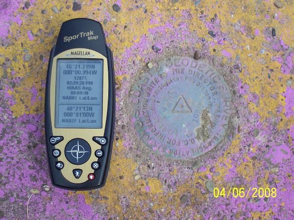
While the recovery note another amusing example of persons performing recoveries oblivious to the plain reading of the description. I wonder how this individual reconciled what he was looking at and the statement that ??...part of the disk is missing...? and the name of the organization on the disk?
I did find myself in a quandary when looking for a specific monument amongst a plethora of them at a NASA facility. Many where not stamped with specific identifiers.Including some set closely together. Upon my first site visit the designation was not stamped on the NASA disk. Interesting site. Lots of sensors. I got to see the NGS FG-5 gravity meter in action at the site.
?ÿ