

We are leasing a lookout and radio repeater site in the National Forest. The lease description is pretty vague, 1.5 acres somewhere in Section 10. We are going to renew the lease and will be writing a better description of the new lease area. So we got some corner records from the USDA-FS Surveyor in Redding. The west quarter corner is visible from the lookout so we set a control point for topoing the mountain top and backsighted the quarter corner (2900 feet southwest). Then I turned to a drill hole on top of a boulder (made with a star drill and hammer) for a control point 2800 feet northwest. The drill hole sees into the northwest corner of the Section below it.
We tied the triangle together with GPS. One cool thing is there is a PBO Station about 50' from my mountaintop traverse point. P337. I put my truck radio on the local ECC frequency and selected CTCSS Tone 4 and keyed the mike. The repeater responded. It works! It runs on solar power.
This place sees Shasta through a gap, Lassen and the Sutter Buttes. The wind on Tuesday cleaned the haze out and everything was crystal clear. Unfortunately my camera doesn't take very good long distance pictures. I failed to get a picture of Shasta. I have one of Lassen, it is OK but not spectacular. The haze had built back in by Thursday morning; the peaks were still visible but not nearly as spectacular.
I know setting up on a high section corner in the Mojave Desert and turning to all the other corners beats this but it is pretty good in Mountainous terrain in Northern California.

I can name that tune in zero notes
Congratulations. I know this must be very unusual for you. Meanwhile, we frequently set up on a section corner and shoot one or more quarter corners from there.
> I know setting up on a high section corner in the Mojave Desert and turning to all the other corners beats this but it is pretty good in Mountainous terrain in Northern California.
meh.... I'd rather be working in the between Lassen, Shasta and the Sutter Buttes. Much more interesting and not as hot, although the Mohave this time of the year is pretty nice.
That's a good story. Like to see the pics.
Back in bean country in MI thumb area (flat as flat can be) I once broke down a section from one setup. Set up on the recorded center of section, and shot in all the section & 1/4 corners I needed with the total station. I couldn't really want to believe all that, but I had some recorded surveys on hand, and my inverse measurements fit everything within acceptance. Maybe they did the same thing, but likely not??
It was still pretty cool.
i turned a traverse point in a 100 acre boundary one time in north ga that was 78'. it was straight up a hill (mountain to some of you) and through rhododendron. it is pretty discouraging to think you have 100 acres to traverse around and you are moving 100' at a time. thankfully that was only about 800' we had to get through and then it opened back up pretty good (250' shots). that was in the early 90s and the boss was charging $0.35 per liner foot of boundary. i would venture to say he lost his tail on that one.
Well the next project is back into the woods. 100 to 200' traverse lengths through brush, trees and dead fall. If we find a 400' leg we think we hit the lottery. You know you earned your pay at the end of the day.
I have to go to the Bay Area right now but I will post some when I get home later, probably tomorrow morning.

> Well the next project is back into the woods. 100 to 200' traverse lengths through brush, trees and dead fall. If we find a 400' leg we think we hit the lottery. You know you earned your pay at the end of the day.
I spent a couple of years doing that sort of thing when I was a much younger man. A 400' shot through dense brush that took you most of a day to clear looks like it's a mile long, especially when it involves the kind of elevation change typical of the Sierra. When you get back to the wide-open flatlands, where you can get 400' shots in every direction all day long, you wonder why those mountain traverses are so much work.
USFS Olympics, 5 to 10 year old clear cuts that had been seeded. 15' canopy of sapplings spaced 2 ft apart with interwined limbs to the dirt. You could not see Burlington red through 3 feet. Long hike in. 5 man crew. 100 yards per day. By the time we finished that one, there was a mile of pungy sticks to dance through to get back to the landing.
Ran into a job with similar conditions years ago near Looking Glass. It was a section that was clear-cut and not reseeded, talk about brush. Ran 6 miles plus of traverse alone, left everything on line at night and only carried the battery, my lunch box, canteen and cruisers axe out. Was armed with a 357, but I wanted the axe with me always. Set a lot of back sights using lath over the point, with two magic marker lines on each side of the plumb bob string, marked after placing a stable lath in position, sometimes needed to use overhead branches, marked by flipping the scope from the foresight and picking the point, marking it and then refining until good. Did get a closure of around 1/12000 if I remember correctly. Thinking about it some more, not so sure the closure was that good, but I do know it was good enough to meet requirements.
jud

Shasta from I-5
clear cuts and unmaintained roads-the brush just springs up, can hardly walk through it.
We needed to get one bush out of our way, the thing was all intertwined. It got me, pulled a branch out which when it came free it whacked me on the face. My nose has a scratch on it, had to put a band-aid on it to stop the bleeding.
Here is a USDA-FS aluminum monument, there is a name stamped on it:
Best picture of Lassen I could get (from the boulder above the Section corner):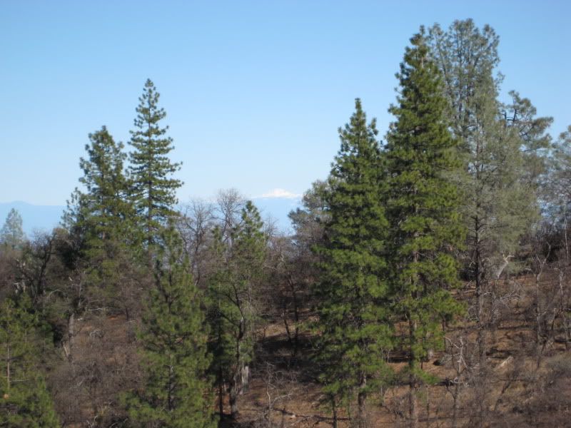
Some snow capped peaks southwest of me, This is in the Coast Range below the Trinity Alps: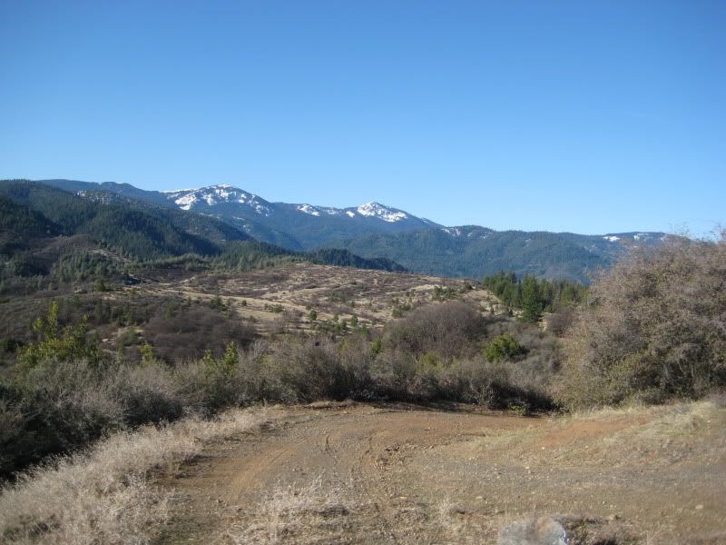
Pattymocus Butte Lookout Station: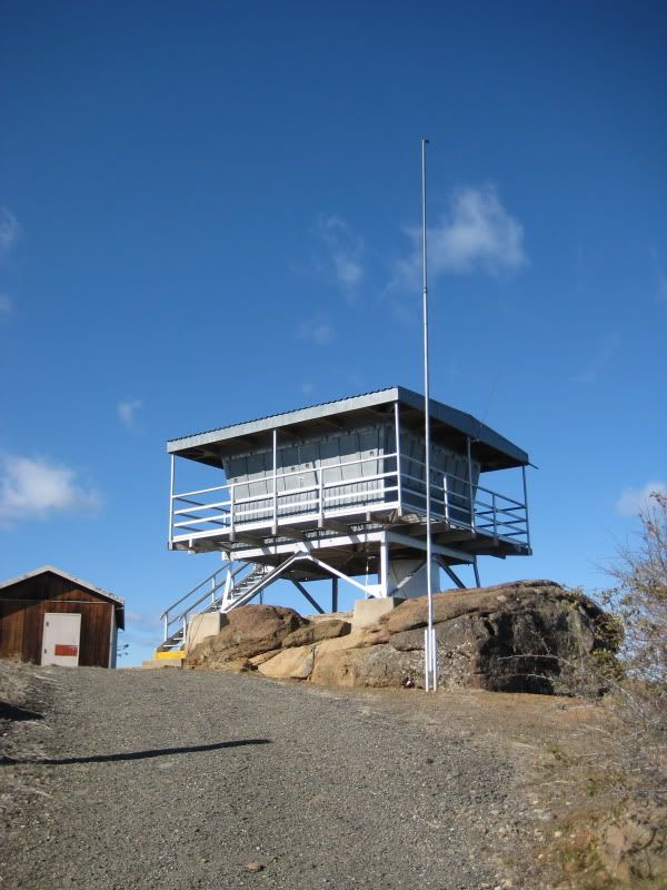
> > Well the next project is back into the woods. 100 to 200' traverse lengths through brush, trees and dead fall. If we find a 400' leg we think we hit the lottery. You know you earned your pay at the end of the day.
>
> I spent a couple of years doing that sort of thing when I was a much younger man. A 400' shot through dense brush that took you most of a day to clear looks like it's a mile long, especially when it involves the kind of elevation change typical of the Sierra. When you get back to the wide-open flatlands, where you can get 400' shots in every direction all day long, you wonder why those mountain traverses are so much work.
I prefer the 1-2 mile shots available in most areas of West Texas. Sometimes on top of a hill shooting across a Valley you could shoot 5 miles or more, if your equipment is capable.