AI Assistant
Notifications
Clear all

Ah, 1837 Galveston Map's Author is Texan !

12 Posts
6 Users
0 Reactions
469 Views
Kent McMillan
(@kent-mcmillan)
Posts: 11416
Member
Topic starter
Translate
English
Spanish
French
German
Italian
Portuguese
Russian
Chinese
Japanese
Korean
Arabic
Hindi
Dutch
Polish
Turkish
Vietnamese
Thai
Swedish
Danish
Finnish
Norwegian
Czech
Hungarian
Romanian
Greek
Hebrew
Indonesian
Malay
Ukrainian
Bulgarian
Croatian
Slovak
Slovenian
Serbian
Lithuanian
Latvian
Estonian
 

I suppose the key to solving certain mysteries is to always be willing to recognize the obvious answer when it is staring you in the face. That happened today around 5 o'clock as I was wrapping up the day's work in the research room at the General Land Office. One of the loose ends from the Galveston project was the identity of the author of a certain map dated 1837 showing the survey of the West part of Galveston Island into lots.

In the last installment, I had begun to think it was drawn in New Orleans, which was concerning, both culturally and otherwise. In this installment, I realized as I was putting my papers back into the folder I'd walked in with that I was staring at a map hanging on the wall that was remarkably similar to the Galveston Island map.

It was the North arrow that caught my eye and made me look more carefully, identifying the draughtsman of the Galveston Island map as Stephen F. Austin's son-in-law, James Franklin Perry. Mystery solved.

http://www.tshaonline.org/handbook/online/articles/fpe44


Posted : May 28, 2014 9:29 pm
Kent McMillan
(@kent-mcmillan)
Posts: 11416
Member
Topic starter
Translate
English
Spanish
French
German
Italian
Portuguese
Russian
Chinese
Japanese
Korean
Arabic
Hindi
Dutch
Polish
Turkish
Vietnamese
Thai
Swedish
Danish
Finnish
Norwegian
Czech
Hungarian
Romanian
Greek
Hebrew
Indonesian
Malay
Ukrainian
Bulgarian
Croatian
Slovak
Slovenian
Serbian
Lithuanian
Latvian
Estonian
 

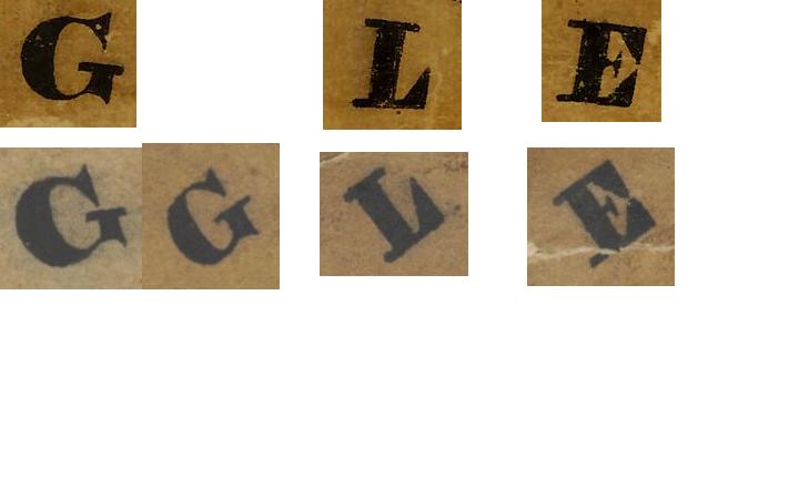
These two labels are taken from the two different maps. The "CITY" on the bottom is from the 1837 Galveston Island map and the "CITY" above it is a paste-up job from shadow fonts on the other map. Coincidence that the hand that drew both didn't know that the shadow lines should be parallel and formed the same letters nearly identically on both? I think not.

Likewise a few other distinctive letter forms common to both maps:


Posted : May 28, 2014 9:47 pm
Andy Bruner
(@andy-bruner)
Posts: 2778
Member
Translate
English
Spanish
French
German
Italian
Portuguese
Russian
Chinese
Japanese
Korean
Arabic
Hindi
Dutch
Polish
Turkish
Vietnamese
Thai
Swedish
Danish
Finnish
Norwegian
Czech
Hungarian
Romanian
Greek
Hebrew
Indonesian
Malay
Ukrainian
Bulgarian
Croatian
Slovak
Slovenian
Serbian
Lithuanian
Latvian
Estonian
 

If he hadn't

spent so much time on those ornate north arrows maybe he could have drawn a "better" map (GRIN).

Andy


Posted : May 28, 2014 10:13 pm
Kent McMillan
(@kent-mcmillan)
Posts: 11416
Member
Topic starter
Translate
English
Spanish
French
German
Italian
Portuguese
Russian
Chinese
Japanese
Korean
Arabic
Hindi
Dutch
Polish
Turkish
Vietnamese
Thai
Swedish
Danish
Finnish
Norwegian
Czech
Hungarian
Romanian
Greek
Hebrew
Indonesian
Malay
Ukrainian
Bulgarian
Croatian
Slovak
Slovenian
Serbian
Lithuanian
Latvian
Estonian
 

If he hadn't

Yes, when the map is lacking important technical details, as that 1837 map showing 10-acre lots drawn at a scale of 1 in. = 1/2 mile did, a very decorative North arrow will be extremely useful to draw the viewer's eye away from the actual information, or lack thereof, presented. :>

http://www.glo.texas.gov/cf/ArcMaps/ArcMapsDetail.cfm?intCounter=1954

http://www.glo.texas.gov/cf/ArcMaps/ArcMapsDetail.cfm?intCounter=1943


Posted : May 28, 2014 10:24 pm
Kent McMillan
(@kent-mcmillan)
Posts: 11416
Member
Topic starter
Translate
English
Spanish
French
German
Italian
Portuguese
Russian
Chinese
Japanese
Korean
Arabic
Hindi
Dutch
Polish
Turkish
Vietnamese
Thai
Swedish
Danish
Finnish
Norwegian
Czech
Hungarian
Romanian
Greek
Hebrew
Indonesian
Malay
Ukrainian
Bulgarian
Croatian
Slovak
Slovenian
Serbian
Lithuanian
Latvian
Estonian
 

Minor correction:

"It was the North arrow that caught my eye and made me look more carefully, identifying the draughtsman of the Galveston Island map as Stephen F. Austin's son-in-law brother-in-law, James Franklin Perry. Mystery solved."


Posted : May 28, 2014 10:29 pm

dave-karoly
(@dave-karoly)
Posts: 11990
Member
Translate
English
Spanish
French
German
Italian
Portuguese
Russian
Chinese
Japanese
Korean
Arabic
Hindi
Dutch
Polish
Turkish
Vietnamese
Thai
Swedish
Danish
Finnish
Norwegian
Czech
Hungarian
Romanian
Greek
Hebrew
Indonesian
Malay
Ukrainian
Bulgarian
Croatian
Slovak
Slovenian
Serbian
Lithuanian
Latvian
Estonian
 

Brother-in-Law?

It's always the Brother-in-Law.


Posted : May 29, 2014 7:07 am
Kent McMillan
(@kent-mcmillan)
Posts: 11416
Member
Topic starter
Translate
English
Spanish
French
German
Italian
Portuguese
Russian
Chinese
Japanese
Korean
Arabic
Hindi
Dutch
Polish
Turkish
Vietnamese
Thai
Swedish
Danish
Finnish
Norwegian
Czech
Hungarian
Romanian
Greek
Hebrew
Indonesian
Malay
Ukrainian
Bulgarian
Croatian
Slovak
Slovenian
Serbian
Lithuanian
Latvian
Estonian
 

> It's always the Brother-in-Law.

The tip-off that the creator of the Galveston Island map probably wasn't a surveyor (Perry wasn't that I'm aware of) is the way in which the magnetic North needle was added to the North arrow on that map. It does look like brother-in-law-quality work.


Posted : May 29, 2014 9:50 am
nate-the-surveyor
(@nate-the-surveyor)
Posts: 10538
Member
Translate
English
Spanish
French
German
Italian
Portuguese
Russian
Chinese
Japanese
Korean
Arabic
Hindi
Dutch
Polish
Turkish
Vietnamese
Thai
Swedish
Danish
Finnish
Norwegian
Czech
Hungarian
Romanian
Greek
Hebrew
Indonesian
Malay
Ukrainian
Bulgarian
Croatian
Slovak
Slovenian
Serbian
Lithuanian
Latvian
Estonian
 

And, as Andy above said, if the north arrow looks like a stray piece of grass, dangling from a fence, with a simple N in there, well, maybe it is Kent's Arrow.

N


Posted : May 29, 2014 10:02 am
Steven Meadows
(@steven-meadows)
Posts: 151
Member
Translate
English
Spanish
French
German
Italian
Portuguese
Russian
Chinese
Japanese
Korean
Arabic
Hindi
Dutch
Polish
Turkish
Vietnamese
Thai
Swedish
Danish
Finnish
Norwegian
Czech
Hungarian
Romanian
Greek
Hebrew
Indonesian
Malay
Ukrainian
Bulgarian
Croatian
Slovak
Slovenian
Serbian
Lithuanian
Latvian
Estonian
 

> Brother-in-Law?
>
> It's always the Brother-in-Law.

That's how most employers get their servants, err employees around here in Houston.


Posted : May 29, 2014 10:58 am
Chris Duncan
(@chris-duncan)
Posts: 220
Member
Translate
English
Spanish
French
German
Italian
Portuguese
Russian
Chinese
Japanese
Korean
Arabic
Hindi
Dutch
Polish
Turkish
Vietnamese
Thai
Swedish
Danish
Finnish
Norwegian
Czech
Hungarian
Romanian
Greek
Hebrew
Indonesian
Malay
Ukrainian
Bulgarian
Croatian
Slovak
Slovenian
Serbian
Lithuanian
Latvian
Estonian
 

If he hadn't

Sounds like maybe he also used all his ink in the north arrow and 3D calligraphy, and didn't save any to put his name on the map.


Posted : May 29, 2014 6:26 pm

Kent McMillan
(@kent-mcmillan)
Posts: 11416
Member
Topic starter
Translate
English
Spanish
French
German
Italian
Portuguese
Russian
Chinese
Japanese
Korean
Arabic
Hindi
Dutch
Polish
Turkish
Vietnamese
Thai
Swedish
Danish
Finnish
Norwegian
Czech
Hungarian
Romanian
Greek
Hebrew
Indonesian
Malay
Ukrainian
Bulgarian
Croatian
Slovak
Slovenian
Serbian
Lithuanian
Latvian
Estonian
 

If he hadn't

> Sounds like maybe he also used all his ink in the north arrow and 3D calligraphy, and didn't save any to put his name on the map.

Part of the reason that the name of the author of the map is presently subject to debate is that the original from 1837 is in poor condition. It has been conserved, but had previously lost significant amounts of paper along the lower margin where the name of the draughtsman would typically appear. It happened to a number of the early maps that were handled quite a bit. That map probably went to New Orleans and back to the Treasury Department in Houston before going to the General Land Office and travelling to Austin in 1839. It had a rough life.


Posted : May 29, 2014 7:04 pm
Chris Duncan
(@chris-duncan)
Posts: 220
Member
Translate
English
Spanish
French
German
Italian
Portuguese
Russian
Chinese
Japanese
Korean
Arabic
Hindi
Dutch
Polish
Turkish
Vietnamese
Thai
Swedish
Danish
Finnish
Norwegian
Czech
Hungarian
Romanian
Greek
Hebrew
Indonesian
Malay
Ukrainian
Bulgarian
Croatian
Slovak
Slovenian
Serbian
Lithuanian
Latvian
Estonian
 

That makes sense

There are maps in the local records in my area in poor condition for similar reasons. What really stinks the way the got recorded here. It was customary in the 19th century for the Clerk of Circuit Court to draw the plats on a page in the deed book or plat book. Basically the surveyor or land owner brought in a plat (or maybe just the work map with bearings and distances on it) and the clerk traced it into the plat book. The originals were returned to the land owner. Years later plat books were pulled apart and placed into slides for plat cabinets. These sides don't allow for very good copies on copy machines (they have air bubbles usually and the clear plastic has a yellow tint to in now), so every one and their brother pulls them out of the slide and handles them to copy them. They eventually end up in rough shape. The thing is once margins and "signatures" are missing, it is not likely to determine the surveyor (unless mentioned in the deed, but most just say see attached map) as all the hand writing is the clerks.

I say "signatures" because the clerk just wrote the surveyors name and survey date on the drawing.

Of coarse this are all maps before the days of seals and such formalities as we have today.


Posted : May 29, 2014 7:54 pm