Another thread (specifically Jim Frame's comment) reminded me that I was going to share an online resource for looking at CORS stations...
I don't think that it has been mentioned here, but it needs to be. Here is the condensed story.
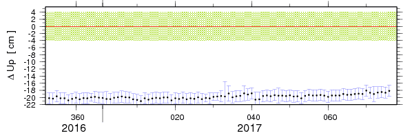
A few weeks ago, a new customer called me to let me know that their receiver was not working. They had occupied a point and the OPUS report looked pretty bad. The solution basically blew up. Checking the NGS short term plot, I found this for PLSB (one of the included CORS sites):

which at first glance looks like the site is 0.2 meters (0.65 feet) lower than the published value.
It was an 1 hr 50 min occupation so I hot-wired the last epoch (I will save a description of this for another thread if anyone is interested) to make the observation appear to be static and hand picked some 'better' nearby CORS. The customers's observation then returned a decent solution and the GPS was fixed.
I took a moment to complain about this to the NGS and they pointed me to the Nevada Geologic Library station page for PLSB:
http://geodesy.unr.edu/NGLStationPages/stations/PLSB.sta
Honestly, I had never looked at this site before. It is amazing.
There is a lot to digest:
o Graphical indications of station antenna changes
o Position Plots for both IGS08 and NA12
but the best thing is the links to nearby earthquake step data at the UC Berkeley Seismology Laboratory.
Honestly, the UNR site is like Geodesy porn. I have spent hours clicking around on the overview map:
http://geodesy.unr.edu/NGLStationPages/gpsnetmap/GPSNetMap.html
(a trick is to click on a CORS square, then when the summary is displayed, right-click and open the detail page in another window.)
So my recommendation for the March 20, 2017 BeerLeg Geodesy Site-of-the-Day is [ UNR ]!
M
PLSB and P271 (a few miles away) are stations that I never constrain for vertical. Both are in a subsiding area, and sometimes it's a pretty wild ride. Same with UCD1; its downward trend is less dramatic, but its seasonal variation is fairly large. I like P267, P268 and SACR for stability hereabouts.
I recommend that California surveyors always check the time series plots of the CORS they plan to use for the reasons Jim stated and others, like secular plate velocities. If the stations you plan to use are PBO sites (over 80% of the NGS CORS in California are PBO stations) they have very nice time series plots available.
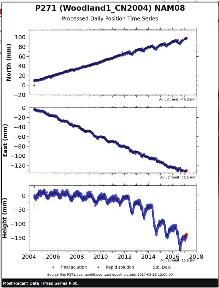
One of the sites Jim mentioned is P271 (a PBO station). The 2010.00 ellipsoid height on the NGS Datatsheet is listed as -17.688 m. Here is what the time series plot looks like:
To get a more accurate current ellipsoid height, I use the Scripps Oribital and Permanent Array Center (SOPAC) tool SECTOR. I computed the position for P271 in SECTOR for Julian Day 70 (a little over a week ago) and the computed NAD83 ellipsoid height is -17.793 m, about 10.5 cm lower than the datasheet value. There are much more extreme cases in California. SECTOR can be accessed here:
The large inelastic drop for P271 in mid-2014 was at least partially the result of an intensive pumping effort associated with a groundwater substitution water sale. The ranch focused its pumping on a well cluster about 3 miles from P271, and the drawdown cone resulted in partial collapse of the aquifer by about 5 cm at P271. The effect near the well cluster itself was about 10 cm.
I was surprised by the density of stations, the majority of which don't show up via OPUS. Around here OPUS seems to access only the Iowa DOT network and two other stations. Leica and whoever else sure have a lot of private stations.
OPUS only uses stations that have been accepted as national CORS stations by NGS. There are approximately 250 active CORS stations in California. However, the California Spatial Reference Network is comprised of approximately 930 active GPS/GNSS stations, which includes those 250 CORS stations.
When working internationally you cans sites on SOPAC almost everywhere. It's amazing.
Even domestic. One our project managers was pointing out that there wasn't a CORS site for over 100 miles. On SOPAC I found 5 receivers and 3 of those were onsite. I always check SOPAC.


