
Activity Feed › Discussion Forums › GNSS & Geodesy › Determine Azimuth between two ECEF Coordinates
Determine Azimuth between two ECEF Coordinates
bill93 replied 1 year, 8 months ago 17 Members · 55 Replies
 Posted by: @cf-67
I realize ECEF is not really relatable to the real world – we need ellipsoids - probably why an “azimuth” is not possible in ECEF, but in my desire to be better at mixing GPS and conventional measurements, or at least using one to check the other, it seems like ECEF could be a useful tool.
Yeah, ECEF would be the way to go if all you have are straight GNSS vectors and are only interested in the XYZ positions – and if you are OK with ignoring measure-up values, and centering and measure-up errors.
But that gets complicated once we start caring about those things, and adding conventional observations to the mix, or start fixing orthometric elevations (rather than ellipsoid heights) at control stations. Modelling and adjusting vectors on the ellipsoid makes it a lot easier to mix everything together and incorporate geoids.
I do remember my head hurting when my Spatial Data Adjustments prof explained all this.
“…people will come to love their oppression, to adore the technologies that undo their capacities to think.” -Neil Postman
@cf-67 you said “probably why an “azimuth” is not possible in ECEF”
That is wrong, you just have not looked in the correct place YET.
JOHN NOLTON

Spill the beans old man…I’m listening ????

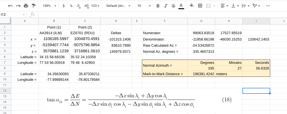
I used Rod Deakin’s formula (18) in a Google Sheets spreadsheet to calculate the azimuth from a PAC in Wilmington, NC to one in Raleigh, NC. A picture of the result is below.
@loyal suggested using INVERS3D. That calculation for the same two points is below. Note that the normal section azimuth is virtually identical to the geodetic line azimuth over this 196+ km distance. They’re pretty much the same over this distance, so Loyal is right; there’s no advantage to the “hard way.” INVERSE3D will work with either lat/lon or cartesian coordinates.
Output from INVERS3D
First Station : AA3914
—————-
X = 1106185.5997 m LAT = 34 15 58.68336 North
Y = -5159407.7744 m LON = 77 53 56.00918 West
Z = 3570881.1239 m EHT = -28.8030 Meters
Second Station : EZ6701
—————-
X = 1004870.4591 m LAT = 35 52 24.10358 North
Y = -5075796.9854 m LON = 78 48 6.42903 West
Z = 3716861.0617 m EHT = 79.1450 Meters
Forward azimuth FAZ = 335 27 56.6849 From North
Back azimuth BAZ = 154 56 48.8666 From North
Ellipsoidal distance S = 196388.4166 m
Delta height dh = 107.9480 m
Mark-to-mark distance D = 196381.4248 m
DX = -101315.1406 m DN = 178630.9554 m
DY = 83610.7890 m DE = -81535.8800 m
DZ = 145979.9378 m DU = -2923.3626 m
Zenith (mk-to-mk) ZD = 90 51 10.60
Apparent zenith distance = 90 43 35.71

Kudos to both for an in depth discussion without calling into question the intelligence, judgement, accuracy,,,,,,etc. of the other…
Well, thank you. @mkennedy is a professional in every sense of the word who is always supportive and always ready to help people understand. I’m a hacker lurching from topic to topic picking up what I can, deriving what I can, and misinterpreting a good bit of the rest. My first rule is that you can’t be afraid to be wrong.
Lots of folks taught me a bunch in this thread. I hope others learned, too.

https://earth-info.nga.mil/index.php?dir=coordsys&action=coordsys
Standard 36 and 37 are good resources


Given an orthogonal triaxial cartesian coordinate system such that two points, A and B in space, are defined by;
XA XB
YA YB
ZA ZB
Then the inverse solution is;
??X = XB ?? XA
??Y = YB ?? YA
??Z = ZB ?? ZA
HD = ?? (??X2 + ??Y2)
SD = ?? (??X2 + ??Y2 + ??Z2)
?ý = TAN-1 (??X / ??Y)
?? = 90 ?? (TAN-1 (??Z / ?? (??X2 + ??Y2)))
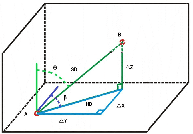
And the forward solution is;
XB = XA + SD ? SIN ?? ? COS ?ý
YB = YA + SD ? SIN ?? ? SIN ?ý
ZB = ZA + SD ? COS ??
Where;
??X = The change in linear units on the X axis on a projection from A to B
??Y = The change in linear units on the Y axis on a projection from A to B
??Z = The change in linear units on the Z axis on a projection from A to B
HD = The linear distance projected on the XY plane from A to B
SD = The slope or mark to mark linear distance in space from A to B
?ý = The angle relative to the X axis on the XY plane on a projection from A to B
?? = The angle relative to the Z axis in space from A to B
Example,
Inverse solution;
Given: PID KV0587 KV4023
NAME R340 H3
X 1,333,485.915 1,331,976.239
Y -4,655,066.754 -4,650,313.574
Z 4,137,276.659 4,143,140.268
Then: ??X = -1,509.676
??Y = 4,753.180
??Z = 5,863.609
And; SD = 7,697.646
?ý = 0.704800918 (RAD) 342.3794289 (DD)
?? = 5.975648330 (RAD) 40.38211803 (DD)
Forward solution;
Given: PID KV5397 KV7145
NAME RNR 14 A NEW BAYSTREET RESET
XA 1,310,203.327 SD = 7,798.0188
YA -4,678,610.771 ?ý = 1.374504500 (RAD) 78.75330653 (DD)
ZA 4,118,240.483 ?? = 1.659032263 (RAD) 95.05554673 (DD)
Then: ??X = 7,618.516
??Y = 1,514.960
??Z = -687.173
And; XB 1,317,821.843
YB -4,677,095.811
ZB 4,117,553.310

5,000 5,000 anyone?


Log in to reply.