
Activity Feed › Discussion Forums › GNSS & Geodesy › Determine Azimuth between two ECEF Coordinates
Determine Azimuth between two ECEF Coordinates
bill93 replied 1 year, 8 months ago 17 Members · 55 Replies
 Posted by: @mathteacher
its position in space
….wait….are going to leap into the abject nightmare of Celestial components that include our rotation and twisting amoungst the solar system and galaxy whilst hurtling along at light speed now too….Im out….my brain just threw a rod and Im not even up to Weds yet…dammit!
😉
 Posted by: @mkennedy
Maybe say GRS80 derived (or calculated) from NAD83 (2011)?
I wouldn’t even want to say that, although I agree it’s (sort of) technically correct.
One cannot point to a mark on the ground and proclaim “This point’s GRS80 coordinates are XXXX“. There are no “GRS80 coordinates” for anything, because GRS80 is not a datum.
Posted by: @mathteacherGRS80 has remained unchanged through all of the realizations of NAD83.
Yep, which is why there is no such thing as GRS80 coordinates. It’s a reference ellipsoid, not a datum realization. NAD83 uses the GRS80 ellipsoid, but positions are computed and referenced to some realization of NAD83, not GRS80.
Posted by: @mathteacherIf you plot Lucy’s current coordinates on both the GRS80(1986) datum and on the GRS80(2011) datum, the point will be in exactly the same place on both projections.
This is where I think we are getting mixed up. There is no such thing as GRS80(1986) or GRS80(2011), or GRS80(XXXX). They don’t exist.
WGS84 is both a reference ellipsoid AND a datum, and there are multiple realizations of it from which computations may be made.
Posted by: @mathteacherGRS80 is an international ellipsoid that was not derived from NAD(2011). Instead, NAD(2011) adjusted coordinate values to position them better on the GRS80 ellipsoid, given more current positional data from a variety of sources.
NAD83(2011) uses the ellipsoid as a mathematical reference, but it is still only theoretical. When we speak of coordinate values, they are in relation to a particular realization of NAD83, which is defined by physical points on the surface of the earth (passive marks, CORS, etc), which are referenced back to that theoretical ellipsoid. Without that realization the GRS80 ellipsoid by itself is meaningless for computations in the real world.
“…people will come to love their oppression, to adore the technologies that undo their capacities to think.” -Neil Postman
What is infinity to the power of infinity?
 I hope everyone has a great day; I know I will!
Now,J_B_, you know that space can be the Star Trek Version or the “don’t violate my …” version. That ECEF coordinate system is three-dimensional, hence it exists in space.
I do have plans to capture Elon Musk’s Tesla Roadster that’s hurtling through the Star Trek space, but I may have to do that in the supernatural world.
5 actually.
Gravity and Time are the other foundational real world simple constraints that dont diverge into the whole other parallel universe of QED.
Brain hurts. im only trying to write legal descriptions, and just started a new job as a survey PM. I’m blowing through all the weak brain cells so the stronger ones can thrive!

I pretty much agree with you. When I wrote GRS80(1986) and GRS80(2011), I meant to write NAD(1986) and NAD(2011). The point I was trying to make is that the ellipsoid doesn’t care about the realization. Lucy’s lat/lon coordinates exist on the GRS80 ellipsoid, the NAD realization tells us what’s there. So, positions exist on the ellipsoid and realizations tell us what we find at those positions. You’re right; without that context, the positions are worthless.
Where I strongly disagree is on the question of whether GRS80 was derived from NAD(2011). GRS80 existed long before NAD(2011) was even dreamed of and it has not changed since its inception. It’s hard to see how NAD(2011) had any influence at all on the derivation of GRS80.
Not mine, dates back to the 1920s, maybe Punch magazine:
There was a young lady named Bright
Whose speed was far faster than light;
She set out one day
In a relative way
And returned on the previous night. Posted by: @mathteacher
Lucy’s lat/lon coordinates exist on the GRS80 ellipsoid,
No.
Let’s take another example. Would you say that 36N, 80W does not exist on the GRS80 ellipsoid?
@mathteacher Right, I would say that lat/long position exists on a given datum (like NAD83), and more specifically, on a given realization of that datum (like NAD83(2011)). And I would say that NAD83 uses the GRS80 ellipsoid to define its shape. In the same way, I would say that NAD27 uses the Clarke 1866 ellipsoid to define its shape.
Coordinates must be associated with datums to have meaning. As noted by you and Melita earlier, GRS80 is used as the underlying ellipsoid (shape) by many datums, so to say that 36W, 80N is a position on the GRS80 ellipsoid is not meaningful.
From a strictly mathematical perspective, I know one could compute spherical coordinates on the GRS80 ellipsoid. But then one would have to position the ellipsoid in space for those to have any meaning, and as soon as you do that, voila!–you have a datum.
Yes, in math, it doesn’t have to make sense.
But, what is/are the datum(s) used in WGS84?
@mathteacher WGS84 (the datum) uses WGS84 (the ellipsoid, which as noted earlier is functionally equivalent to GRS80). WGS84 is that rare bird that is both an ellipsoid and a datum.
NAD83 may be the rare one. Very helpful discussion, thank you.

FWIW,
I recommend the three links below for more details on the relationship between a reference system and a geodetic datum.
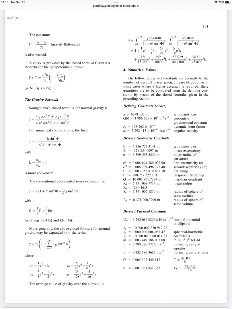
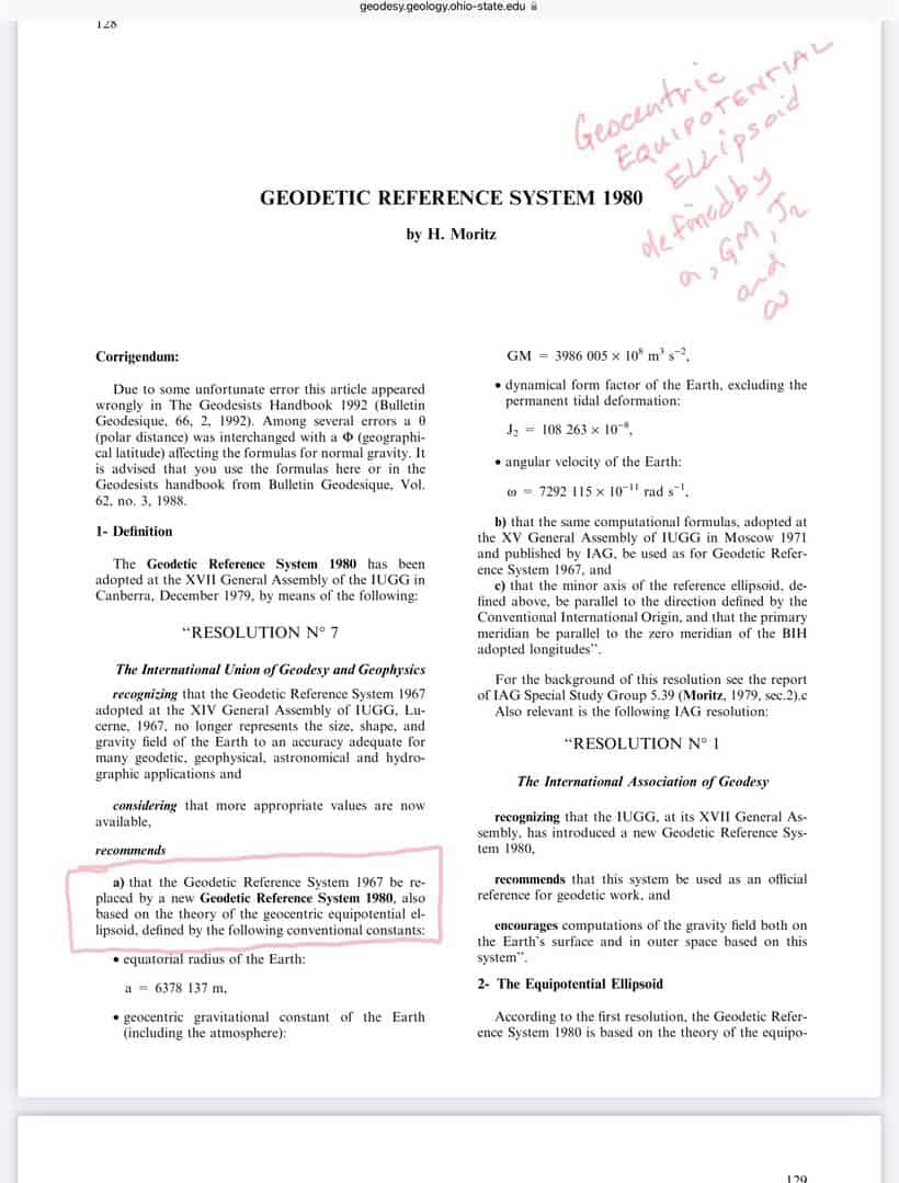
The first link is to Moritz??s paper on GRS 80. Note the four defining parameters are a, GM, J2 and mu. GRS80 is intended to be a ??geocentric equipotential ellipsoid.
GRS80 parameters
https://geodesy.geology.ohio-state.edu/course/refpapers/00740128.pdf
ITRF Technical Notes from IERS
https://www.iers.org/IERS/EN/Publications/TechnicalNotes/TechnicalNotes.html
NGS professional Paper NOS 2: North American Datum of 1983
https://geodesy.noaa.gov/library/pdfs/NOAA_PP_NOS_0002.pdf
See chapter 22 ??Relation of NAD83 to WGS84? by Charles R. Schwartz
This relationship has changed due to the decision by DMA/NIMA/NGA to make and keep WGS 84 consistent with the current implementation of the ITRF.
Attempting to navigate the NGA for links was to no avail.
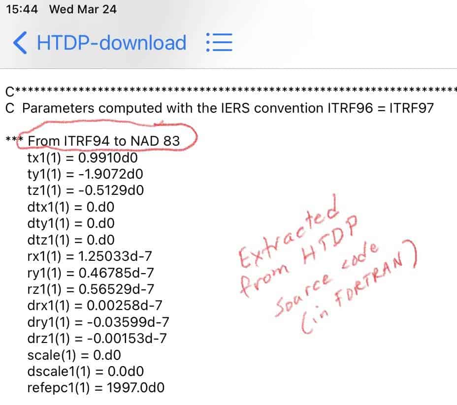
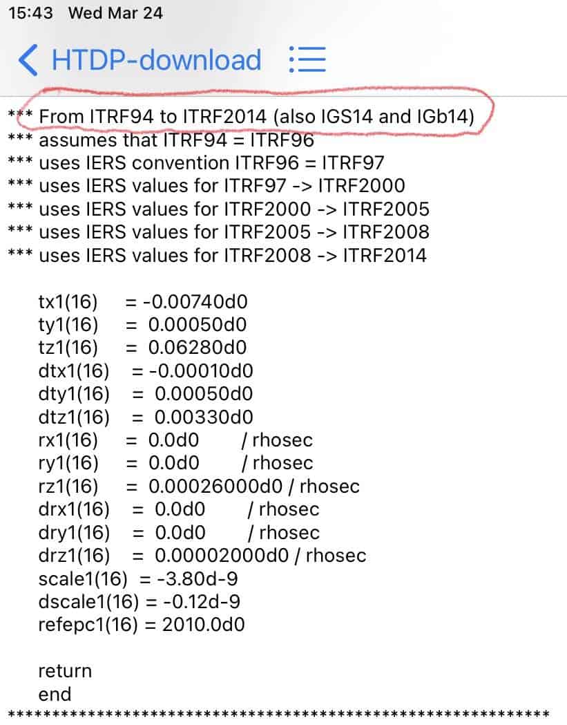
The transformation parameters NGS HTDP uses to go between ITRF to NAD83 first uses itrf94 to NAD83 then itrf## to itrf94.
You know what I want to know, is where the hell are all the gis people?
We need someone, just one person in that group has to have something to say or ask about this process don’t they?????
And not me I’m not that the defacto GIS person, someone else without land surveying experience.
This has been an awesome discussion from front to back.
Indeed, I did type GRS80 when I meant to type NAD83(2011). Poor proofreading.
I apologize for the confusion and thank you for being kind.
- Posted by: @jitterboogie
You know what I want to know, is where the hell are all the gis people?
We need someone, just one person in that group has to have something to say or ask about this process don’t they?????
@mkennedy is a GIS expert, and if I am not mistaken a senior engineer at ESRI. I have found several answers to my GIS questions in her posts when searching the forums.
GIS folks aside, in my experience, a not-insignificant chunk of licensed surveyors get impatient when geodesy or geodetic datums are discussed. It’s “theoretical” or “academic” and has a negative connotation, in part because it is associated with GNSS surveying or “button-pushing”.
“…people will come to love their oppression, to adore the technologies that undo their capacities to think.” -Neil Postman 
Wow, this thread certainly developed way beyond the original question! And glad it stayed cordial.
My curiosity with ECEF was piqued by two things:
a) They seem to exist without the need for any ellipsoid – nicely avoiding that whole source of WGS/GRS confusion.
b) A GPS vector, which is expressed in ECEF, is a true, unscaled distance that is comparable to an EDM distance, allowing comparison with total station measurements while nicely avoiding the whole Grid/Ground issue that often interferes with GPS/Conventional mixing
These are 2 confusing issues!
I realize ECEF is not really relatable to the real world – we need ellipsoids - probably why an “azimuth” is not possible in ECEF, but in my desire to be better at mixing GPS and conventional measurements, or at least using one to check the other, it seems like ECEF could be a useful tool.
Thanks for all the answers!
 Posted by: @cf-67
a) They seem to exist without the need for any ellipsoid – nicely avoiding that whole source of WGS/GRS confusion.
ECEF doesn’t need the ellipsoid, but does need to specify the 0-0-0 origin, which will usually be expressed as the origin of a defined ellipsoid, so you can’t completely avoid the issue.
.Understood. I wasn’t besmirching her and everyone else that dig deeper in the bowels of the geodesic sausage making. The overwhelming majority of people I’ve come into contact with or worked with in GIS have been just that, button pushers, and their depth of the understanding into the models and theory have been severely limited. Mine not withstanding, I stand on yours and all the other shoulders learning about what I do not know or vindication of what I’ve been taught. So I retract my original qtip windmill tilting attack upon GIS, and still enjoy this discussion sincerely.


Log in to reply.