

Ask A Surveyor
Public Group
Public Group
Active a week ago
If you are a landowner seeking advice from surveyors, please post your questions and issues here.... View more
Public Group
Organizer:
- Organized by
-
Group Description
If you are a landowner seeking advice from surveyors, please post your questions and issues here. DISCLAIMER: All surveying-related questions should be consulted with someone licensed in their jurisdiction and hired for professional services. The answers provided here are not to be construed as official advice from a professional that you would otherwise obtain in your local area.
WA Homeowner looking for advice
WA Homeowner looking for advice
Posted by Archer322 on January 22, 2019 at 6:01 amHi folks. I’ve been searching through this forum and have found a lot of good info, but I’m hoping I can get some advice.
I need a survey to determine where trees lie on my property line with my neighbor, I came home for lunch last week to him cutting them down. Many are still standing but several have been ground to the stumps.
I’ve called several surveyors and got a hold of one who said it would be at least $1,500 to get a record of survey for my lot. I was wondering if there were any alternatives to a complete survey in cases like this? I understand if not since it might not be either possible or worth a surveyor’s time. But this guy also owns another property to my north and suggested he’d start making things hard. He’s part of a HOA and they say he’s been pushing them for some time, I guess it’s my turn now. I found one monument at the South corner but couldn’t find the North one.
Appreciate any advice, thanks.
ETA: I’m in unincorporated Snohomish county
nate-the-surveyor replied 5 years, 3 months ago 12 Members · 21 Replies- 21 Replies

I’m not licensed in Washington, but in general it’s necessary to figure out where all the lines of a parcel should be placed when surveying its boundaries. If you only mark one of them on the ground, there’s some reduction in cost, but not much. And there are usually state laws or regulations that affect how surveys are performed.
One question that occurs to me is, has the neighbor had the line surveyed? If not, how does he know that he has a right to cut the trees?

No alternatives, and in fact you may also need to spend some money on an attorney. But the survey is the first step. Make sure you describe the entire problem to the surveyor so they know what needs to be done.

I am licensed in Washington.
If your neighbor has, in fact, cut down trees on your property then he is going to be paying for your survey and your attorney. Which you need. You need a boundary determination by a licensed surveyor. State Law says that when a licensed surveyor determines a boundary he/she must file a Record of Survey. And you need an attorney to make sure the neighbor does the paying.
$1500 is dirt cheap. Maybe too cheap for a really proper job. Especially since we know that this thing is headed for a showdown. Costs vary greatly from site to site, but my baseline price starts at double that.

This sort of dispute is very common in my 40+ years of surveying experience. Determining the value of the dispute is the hard part for the land owner. This is especially painful when the surveyed line shows the neighbor to be correct. But, land owners should know where their boundaries really are so as to avoid such disputes.

You may wish to get some perspective about one issue and find out what trees are worth in your area. It may open your eyes to the importance of this issue. The $1500 could seem like a bargain if your neighbor cut some valuable trees of yours down.

Mature fir / cedar/ hemlock might be worth several thousand dollars. Alders are weeds and have little commercial value.

Ornamental trees may have value too, depending on your State Laws. I know nothing about Washington.
You need a lot better Surveyor than a 1500 dollar Surveyor, unfortunately. You need a boundary expert Land Surveyor and an Attorney that is an expert in Real Property.
If you are fighting a fire you’d rather have a 2-1/2″ high pressure hose than a garden hose. The garden hose is cheaper but not much use when your garage is fully involved and you are trying to save your house.

I agree with Mark above. But I recommend that you retain an attorney first if you think that this behavior will continue beyond what you see now. Find a local person who has experience with this type of situation. Choose your surveyor by asking if they are willing to get involved in a boundary dispute, if they are familiar with the vicinity and if they are insured.
The fee that you have been given would depend on many factors all of which we don’t have at this point. I can tell you that the Snohomish County recording fee for the survey is about $190 (I charge $250) which should be included in any fee proposal you receive.
PM me if you want to discuss this further.

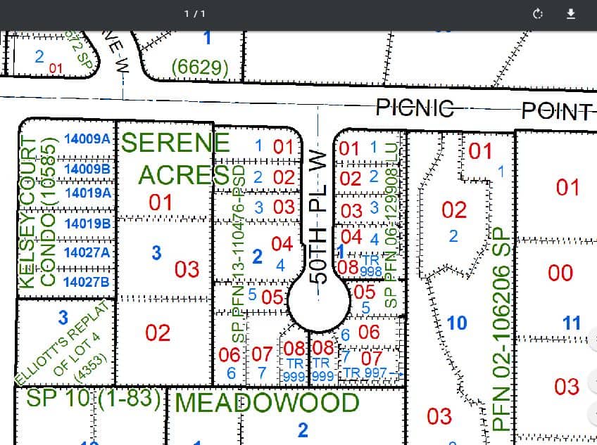
Wow, thanks for the advice! Yeah I’ve been looking into this more and it seems this could be a significant issue. He’s cut down 8 trees total, 2 of which were 45-50ft cedars, and damaged hedgerows that are several feet on my property, I’m not sure the species of the smaller trees (the ones left are a mix of spruce and fir) but they range in trunk diameter from 8-12 inches. He definitely didn’t have the line surveyed. I have a plan drawing from the original developer when they asked me for permission for a reduced setback, it shows the location and diameter of the largest trees there straddling my property line. I know that drawing has no legal authority but it was enough to convince him to stop. I’ve looked it up and found what looks like the latest survey that was done for the short plat map for his development, that’s what led me to the monument on my southern lot edge. I’m wondering if he didn’t remove the Northern one because it’s nowhere to be found (these were laid in 2015).
Anyway I don’t mean to take up too much surveying forum space with neighbor drama, but I really appreciate the advice. Getting an attorney certainly sounds necessary, I just wanted to confirm I have authority over these trees before I made a hassle.
The surveyor who did the short plat is likely to be the guy who can do this survey work quickest and for the least cost.
Yeah that would make sense, my only concern would be him not being motivated to possibly correct errors in his previous work, perhaps I’m being too mistrustful. I’ve attached some screenshots of what I’ve been looking at so far, understanding I need an official survey I just want to see if anything jumps out to those with experience in these things. My property’s legal description says basically Lot 3 of SA3 except S131ft and N143ft and defines the ingress/egress easement.
One question, I see the “new” property line from his short plat has our shared boundary angled 16’02″E. But the original plat has those running due N-S. If true then at my northern boundary the line would shifted over a foot or two, presuming the “old” fences on my property were placed along a N-S line. I’m highly suspect of my analysis, but this is making me wonder if I’m in a stronger position than I thought.

Original Plat, book 12 of plats in SnoCo, probably from way before NAD83/91 and state plane. “North” and “West” probably mean “parallel with the south or east section line” and not an absolute direction. More of a shorthand reference. The later surveys are on NAD 83/91 and are likely using or derived from state plane. A minute is roughly 1.04 inches at 300 feet, so yes it could be inches different but I doubt it. It’s a difference that would probably vanish once all the various maps were on the same basis of bearing.
On the map showing the trees, it looks like they are partially on your lot and slightly more on his. What needs surveying is the circle of each stump and the percentage of ownership of each. If the court decides he was wrong to cut the jointly-owned trees without your approval, you may be entitled to damages, and that curious Washington phenomenon of “triple stumpage” may apply.
Long ago when the original Plat was made the Surveyor, lets call him Ralph Kramden, would select one of exterior lines of the big Tract being divided up, look up its record bearing and then relate all the rest of the bearings reported on the map to that. The record bearing probably did not exactly relate to true north to begin with then Mr. Kramden’s work was not exactly perfect either so that the lines laid out won’t perfectly match what the Plat shows.
Then the modern Surveyor uses much more accurate instrumentation to determine the actual true bearing of that line, it’s the same line pointing in the same direction but the direction reported varies due to differences in how the work is done and the instrumentation available to do it.
16 minutes is actually a very small difference, some of the Section lines supposedly run NORTH in the Western Mountains are sometimes 30 degrees off or more but the line where it was laid out is considered to be correct otherwise we would have a huge can of worms to try to put back in the can, an impossible task.
Ah, yeah the original plat is from 1948, but is what apparently still defines our properties legally. I had suspected it is to be interpreted to the new basis of bearing show in the short plat, thanks for that. Regardless of whether the line moves a matter of inches the trees leaned significantly to the West and would have crossed the plane of our boundary, unfortunately he’s ground them to the stumps but there are several still standing that do the same.
I see, so it’s not so much there’s a conflict with the new and old, it’s that the new is more accurately defining the position of the old. That clarifies how I should look at this and gives me more confidence in the accuracy of the newer survey. Also, Northeast corner of my lot where those properties meet shows a joggle on all country records, but the fences are in line as built, so there’s clearly a discrepancy with the recorded vs. built environment I should see to getting sorted out.
You have a real and current situation going on. Best use of this board for you is to contact one of the WA surveyors who responded. We talk a lot about theories, and cases that have already been decided, and the direction things are heading on this forum. But it’s not for solving a developing real world issue. There’s an investigation to be done by a qualified surveyor, analysis to follow, and it’s not necessarily in your best interest to go with the original subdividing surveyor just to cut costs. I would recommend someone else.
Right on, thanks Duane, agree about going with a different person. I’ve spoken with someone from the site offline already and I’m going to get this ball rolling. Appreciate the advice from the folks here, thanks!

I am licensed in Washington and used to mediate boundary issues. There are some very good points on this thread but this situation is beyond survey questions.
Get yourself an attorney.

I like all the suggestions above. I’d even be in favor of you doing some metal detecting, with a 100′ tape in the neighborhood. Remember, distances are always horizontal.
Then, hire a surveyor. Tell him what you did. Since its YOU who has to pay the surveyor, lawyer, and landscape repairman, you will have a better feel for all the issues. Also, well mark the corners, by adding steel fence posts. Or such like. Place the post near, but not touching the monuments. A few inches away, and on the line.
Also, you REALLY will want a lawyer that truly enjoys boundary law, and such. Check with several lawyers. You need one you can work well with. Also, surveyors. Get one that likes court. Discuss which lawyer, with the surveyor, and discuss which surveyor, with the lawyer. You are the one who is paying. Make sure you know all you can, before taking off on this trip.
Respectfully,
Nate
Yep, getting as much info as I can before I go making any claims. I ran a line and all it told me was that it was being deflected by the trunks that are still standing, suggestions for establishing a plane through the other trunks are appreciated. I have some T posts I can set, good suggestion.

Log in to reply.