

Ask A Surveyor
Public Group
Public Group
Active a week ago
If you are a landowner seeking advice from surveyors, please post your questions and issues here.... View more
Public Group
Organizer:
- Organized by
-
Group Description
If you are a landowner seeking advice from surveyors, please post your questions and issues here. DISCLAIMER: All surveying-related questions should be consulted with someone licensed in their jurisdiction and hired for professional services. The answers provided here are not to be construed as official advice from a professional that you would otherwise obtain in your local area.
Platted Utility Easements! Help appreciated!
Platted Utility Easements! Help appreciated!
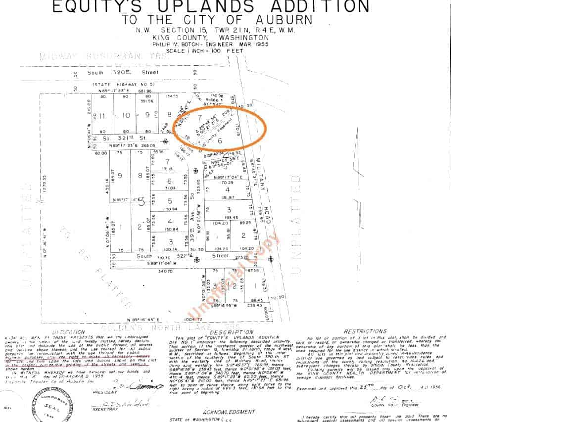
Posted by the-dark-knight on October 26, 2018 at 3:42 amHello – I am under contract to purchase a property and I found out from Title that there is a platted utility easement going through the parcel. The only information we have about this easement is from the plat map from 1955 which only shows that a 10′ utility easement goes through the the middle parcel I’m trying to purchase. The plat map as well as county records does not indicate anything in regards to a grantor, grantee, use, restrictions or other information regarding the easement. Is there any way I can get rid of this platted utility easement for good or have it removed? I’ve looked for grantees/beneficiaries but there’s absolutely no information about this easement. I’ve attached the map for your review. Any input would be highly appreciated.
 Norman_Oklahoma replied 5 years, 6 months ago 8 Members · 25 Replies
- 25 Replies


It doesn’t go through the middle of any parcel, unless the parcel you are buying is LOT 6 and LOT 7.
It appears to be the southeasterly five feet of Lot 7 and the northwesterly line of Lot 6.

Pretty faint lines and hard to destinquish. It appears the lot line common with Lots 6 & 7 is also the center line of the easement with the easement being 5 feet on each side of the common lot line. You probably won’t find anything in the records regarding a grantor or grantee and is essentially created by the plat. Are you planning on buying both lots? or just one of the two? Otherwise, the easermnt is along the common lot line.

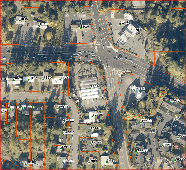
Looking at the location in Google Earth the OP is very clearly occupying both lots. It is commercial property.
While it doesn’t specifically say so I think that we can assume, since it runs from one public road right of way to another, that the easement is to the public. The grantor is the plattor, and the beneficiary is the City of Auburn. It does say that it is for utility purposes. Presumably, there is a utility (very likely storm and/or sanitary sewer) buried in that strip of land. If you want to get rid of it you first have to determine what is buried there. If there is nothing then things get easier. Next, you have to provide an alternate service, suitable to the utility provider, over a route more to your liking. That means rebuilding whatever is there at your expense. Then the easement holder may release the easement. Ultimately public easements are released by resolution of city or county council.
This is the sort of thing that a civil engineering firm can lead you through. They will employ surveyors as needed. But be forewarned, you are looking well into 6 figures to get this done. If you are planning on redeveloping the property maybe it could all be done in conjunction with all the rest and not hurt so bad. But it isn’t something you are going to do yourself casually by filling out some forms.

Sorry. Just to clarify, the lot lines have changed. The parcel I will be purchasing contains lots 5, 6 and a part of 7 so it does indeed go through the middle of the parcel.
Just to clarify, the lot lines have changed. The parcel I will be purchasing contains lots 5, 6 and a part of 7 so it does indeed go through the middle of the parcel. The plat map I??ve attached to my initial post does not reflect the new lot lines
Thank you very much Mark! This is super helpful and exactly the direction I was looking for. So the first course of action would be to contact the city and or county that the property/easement is under correct? Then find out whether that easement is being utilized and get a view as to whether it can be moved? Would a general civil engineer be more suitable to handle this or would it be ok to go directly to a surveyor? Thanks so much again!
Unless the platted lots have been vacated and replatted, the lot lines still exist as originally platted
I see. The new county assessor maps have different lot lines and showing no easement so I assume that it has been replatted? Does the replatting mean that the old utility easement has been relinquished?
That is something that has to be in the records somewhere. A document for the vacation of the original platted lots and estinquishing the easement or a new plat depicting the new platting. Assessors plats need to be taken with a grain of salt. Arbitrarily just taking them off without some documentation to back that up, doesn’t mean that the original platting no longer exists. It is critical to determine if there are any utilities in that easement. sewer, water, buried power, buried telephone, TV cable, etc.

Assessors maps show tax lots. This is something different than platted lots. The assessors maps are created as an aid to collecting taxes, not for determining boundaries. Every jurisdiction’s maps have their quirks – some may have a little more information than others. They are often a convenient and easily obtained map to use for pre-planning and/or discussion purposes. But they are not definitive as to title, boundaries, areas, easements or, really, anything other than tax lot numbers.
Once a line is platted it continues to exist, at least in theory, until it is superceded by a replatting. Bits and pieces of platted lots can be split off or combined by description, but the plat lines continue to exist and govern the described lines.

It looks like someone was permitted to improve the property with total disregard to this easement. Federal Way hasn’t been incorporated for that long, so it was probably permitted by King County. Good luck in getting any information out of either one of them, about that…
Your best bet will be to hire a good Engineering/Survey firm in that area and let them search this out for you. Both Barghausen and ESM have been in this area for a long time and should be able to provide you with a solution.
Good luck!
EDIT-It looks like the health department has some information on past septic system permits. This might be a good place to start…
Go to this site and enter your parcel number:
I hope everyone has a great day; I know I will!
All due respect, this is a legal issue and you should consult a land use attorney for advice. You should also have a land surveyor, local if possible, review title and make a site visit. This real estate transaction warrants professional opinions and you should be able to justify the time and cost.
I note that there appears to be a King County Public Works survey for street improvements adjacent. And that the buildings that are on the property are greenhouses that may have been considered temporary in nature but have been in place since 1995. King County may be able to provide copies of permits and or site plans.
Thank you very much for the input! Yes there is a septic system on site – it’s near the SFR on the south side of the property. I actually got in contact with the water/sewer company for that area (Lakehaven) and they mentioned that they do not have any records of using that easement except that there was a 4″ water main there probably prior to when that plat map was created. I was also able to get in contact with King County (jurisdiction the property was under when the plat map was created) and they said that they had no current interest in the easement. I’m trying to get a hold of Federal Way to see what kind of records show up and whether or not we can get that easement moved or removed.
Update – i contact both the City and County and both confirmed that they have no records showing that they have an interest in the easement. If i’m not mistaken, if a platted public utility easement is present on a plat map, wouldn’t the grantee of the easement be the jurisdiction (city/county etc) in which the property is located? I asked Title and they had no other records of that easement other than what’s showing in the plat map.

Why don’t you call for utility locates on the easement and find out if there’s anything buried through it. If it’s not been used by any of your utilities it would likely be a simple matter of vacating the easement through a platting action. If nobody is using it they’re not likely to object if there’s an equal practical alternative. If locates reveal buried gas, power, fiber optics, you can cut your losses early as relocating them will get into big money.
WillyThe easement has been there since 1956; the nursery has been in place since at least 1995 and there has never been a problem. why is it an issue today?
I hope everyone has a great day; I know I will!That??s a valid point. The issue is that the easement becomes a cloud on title so the resell value decreases significantly. I don??t think that a bank would be able to finance any sort of development or project with an easement running through the property in that there??s always a slight chance that a party comes to claim the easement. Again, it??s just a cloud on title and an encumbrance
Thanks for the suggestion. I believe that is our next step. If there are no utilities running through the easement, how does one reach the decision makers at the utility companies to reach an agreement to remove or relocate the easement. Logistically it seems like an uphill battle to try to get the decision makers ina room to hash this out. Or is there a way to get this resolved with the city or county?
Thanks for the suggestion. I believe that is our next step. If there are no utilities running through the easement, how does one reach the decision makers at the utility companies to reach an agreement to remove or relocate the easement. Logistically it seems like an uphill battle to try to get the decision makers ina room to hash this out. Or is there a way to get this resolved with the city or county?
I’m not sure about the process where you are but here you would hire a surveyor and start the replatting process with the local platting authority. The surveyor would prepare the preliminary plat presumably vacating the utility easement and making any other changes to the boundary configuration such as vacating a lot line to combine lots, dedicating a new utility easement to supplement the one being vacated, ect.. As part of the platting process that preliminary plat would be submitted to all the utilities for their comments. As long as they don’t object during the comments period, you’re home free. If one does object, you work with them to find a satisfactory alternative. If it means relocating existing infrastructure and you’re willing to pony up, that’s a possible solution. If you expect them to do it on their dime, they’ll likely tell you to pound sand. Once the plat is approved and recorded, the easement in question ceases to exist and the new plat supersedes the old one and becomes the new legal description for the property. That in a nutshell is how it works here. How it works there I know not.
WillyI wouldn’t expect them to have any other record. There is the plat. That’s all they need. As a matter of fact the utility itself in the ground would be enough even without the plat. Let’s not over-estimate the qualtity and completeness of the city/county records of their own facilities. If Auburn is like every other government agency in the universe, their records of such things are a hit and miss mish-mash.
If the easement is for a water main that is good news for you. It’s going to be easier to reroute a water line than it would be a gravity dependent sewer or storm drain pipe

Log in to reply.