

Ask A Surveyor
Public Group
Public Group
Active a week ago
If you are a landowner seeking advice from surveyors, please post your questions and issues here.... View more
Public Group
Organizer:
- Organized by
-
Group Description
If you are a landowner seeking advice from surveyors, please post your questions and issues here. DISCLAIMER: All surveying-related questions should be consulted with someone licensed in their jurisdiction and hired for professional services. The answers provided here are not to be construed as official advice from a professional that you would otherwise obtain in your local area.
Grid or true north?
Grid or true north?
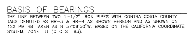
Posted by bernardc on May 14, 2023 at 4:38 amI’m looking at a recorded map (with angles matching the parcel map) and I can’t quite tell whether the angles are grid or true north. I’m leaning to grid. The following two notes don’t quite indicate one way or the other. Which is it? The distances are ground, not grid. So why use grid angles?
 bernardc replied 11 months, 3 weeks ago 12 Members · 22 Replies
- 22 Replies


It clearly states the basis of bearings is on the grid CA Zone 3 coordinate system as defined by two pipes on the site. I don’t see any notes pertaining to ground vs. grid distances. The simplest explanation is that the surveyor was looking for the best way to relate his bearings to a previous survey they did by finding the two iron pipes and he most likely used a ground measuring instrument if indeed they are ground measurements.

I generally include a statement relating Grid to Geodetic north (I dislike the term true north) when working on communication sites since the antennas need to be oriented based on Geodetic north. My map bearings are based on the grid though.
I agree with Norm that the basis of bearings is plainly stated as grid north while there is no mention of how the distances are represented.

Clearly the bearings are based on the California Coordinate System, Zone III.
Don’t know what this grid is you speak of.

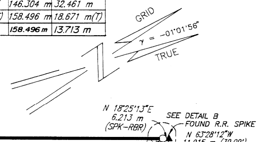
That’s a standard note indicating that the basis of bearings is CCS83 Grid, and the north arrow is showing the convergence angle.

Don’t know what this grid is you speak of.
You don’t? The word is right there in the second image in my post.
But let me give you a bit more background. Quoting from NOAA Manual NOS NGS 5, titled State Plane Coordinate System of 1983:
As with SPCS 27 or any plane-rectangular coordinate system, the SPCS 83 is represented on a map by two sets of uniformally spaced straight lines intersecting at right angles. The network thus formed is termed a “grid.”
If you’re still confused, please let me know.
The state coordinate system is a grid, there are an infinite number of grids, even if the survey was started using a true north bearing somewhere it would still have been a grid survey. So the answer is yes it’s a grid survey.
What the bearings are based on was stated as California Coordinate System and the zone is given. So that’s the particular grid its using but the California Coordinate System isn’t the (only) grid, it’s simply a grid as the NGS sheet says.
Then you ask if the distances are adjusted to a surface near the ground. Can’t tell from the information given. But if you do wish to know if it’s truly “true north” you can calculate the figures using the given bearings with no adjustments and it will not close.
Sometimes the convergence angle is a requirement to indicate. Don’t know if this is the case here or the surveyor is doing this to be more complete with the drawing. What it does tell you is where the survey is located longitudinally.

That statement is not terrible, but not great either. I can read between the lines to figure it out but it could be a lot more clear.
It’s far cleaner to explicitly state “all bearings shown hereon are [state] Plane Coordinate System, XX Zone grid bearings” before stating a single line between two monuments as a BoB and making sure it is called out as an observed SPCS grid bearing rather than one I am fixing everything to.
Now, here it looks like they are indeed fixing it to a previous document’s basis of bearings, so not a big deal.
The big issue for SPCS surveys, especially being in CA with the amount of movement there, is that we need information about the geodetic datum and how it was derived. Which reference frame and what epoch? Based upon NCN/CSRC? Which stations were tied to and how?
The convergence angle is pretty much meaningless except as a generalization unless it specifies the point at which it was computed.
“…people will come to love their oppression, to adore the technologies that undo their capacities to think.” -Neil PostmanThe big issue for SPCS surveys, especially being in CA with the amount of movement there, is that we need information about the geodetic datum and how it was derived. Which reference frame and what epoch? Based upon NCN/CSRC? Which stations were tied to and how?
I will agree,,,,,,,,,if there are coordinates stated. If it’s only bearings (there should be a distance statement) will it even matter, even in CA, what epoch, which stations?
I’m genuinely curious if there would be a difference in CA. Here it won’t matter for bearings if 83(93) or 83(2011) is used as a basis. A slight change in the coordinates, but no measurable difference in bearings. If it does effect bearings that’s pretty crazy movement.
Bearings are calculated directly from coordinates.
It’s fine to run a conventional traverse and held a record SPCS azimuth between two points, but it needs to be clearly indicated, and the record geodetic basis stated (if known).
Whether coordinates are shown or not, when calling out for a projection of any kind (anything other than assumed-datum conventional-only survey) the geodetic datum must be clearly defined. Without it the coordinate system statement is incomplete.
“…people will come to love their oppression, to adore the technologies that undo their capacities to think.” -Neil Postman
The thing that confuses us laymen is the term “based on.” Grid north is calculated from coordinates and true north can then be calculated from grid north. Both are “based on” a grid but it’s not at all clear to me which was used.
I glean from his statement that he’s referencing two pins that have a record bearing N57-09-50W shown on a filed plat, and they are declared on that plat to be on California Coordinate System bearings.
But, I don’t know anything about California filing and I may be wrong that it’s a plat reference.
As far as the convergence, that’s done often to show the rotation to “true north” clearly bearings on the plat are not “true north”. It wouldn’t make sense to show convergence if they were.
That makes sense.

@john-putnam “True North” has come to be somewhat nebulous. In the PLSS, True North is astronomic, although BLM has taken to referring to “Geodetic North” when they were dealing with me at the EBCI. The difference is the LaPlace correction. Using the term “Astronomic” or Geodetic is preferred as it is explicit as to what is being referred to.

and then there’s: the difference between astronomic and geodetic north is called the Laplace’s correction
 I hope everyone has a great day; I know I will!
@dougie t-T. Thats how lol. Love the meme
 I hope everyone has a great day; I know I will!
What is a thing that starts with T ends with T and filled with T?
I hope everyone has a great day; I know I will!
@dougie : A teapot
The thing that confuses us laymen is the term “based on.” Grid north is calculated from coordinates and true north can then be calculated from grid north. Both are “based on” a grid but it’s not at all clear to me which was used.
The grid bearing is based on grid coordinates, which are based on geodetic coordinates, which are referenced to the underlying geodetic datum.
If a projection is being used (not just an assumed Cartesian system) everything starts with the geodetic datum.
Unfortunately a lot of surveyors consider geodetic datum citations to be “elitist” or an indication of “button-pushing” or “mathemagical surveying” rather than a critical piece of information that allows subsequent retracement surveyors to follow in their footsteps more easily.
You’re gonna have to show that to me. I’ve never seen any rotation between epochs.
While it’s not common (seen it on the west coast & AK depending on location, size and date) it doesn’t mean that the geodetic basis and the method of tying to it aren’t critical information that helps the next surveyor.
The relative slopes and elevations on a topographic survey site may not change, but the base datum might, so we still reference it.
“…people will come to love their oppression, to adore the technologies that undo their capacities to think.” -Neil Postman
Log in to reply.