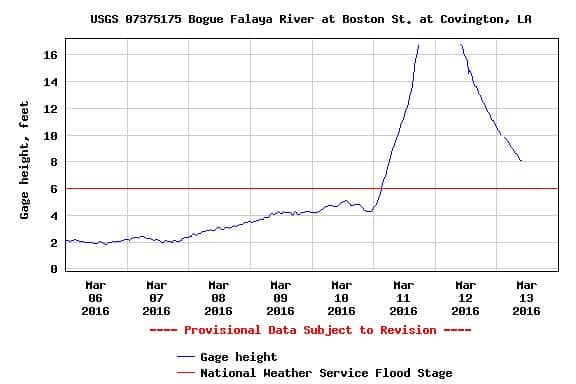
Historical flood has been a term used here frequently in the last few days. ( I'm have tired of it already)
Here is the chart from the USGS real time gauges. This one is closest to me . Bridge is about 3/4 mile from the house. Never seen it leave the chart before. I wonder if this is common. Maybe [USER=34]@Dan B. Robison[/USER] can say.
I was at the bridge on early Saturday and the water was moving fast about a few inches from the bottom bent. All the access roads were covered with water.
In 1983 flood , the old bridge was breached an it was decided to tear it down and build the current bridge.
as a side note in reference to Wendell's post about FB usage. Someone I know on FB posted a 12 sec video of a road that washed out in her neighborhood. Her and a few of my friends live in that area about a 1/2 mil from here. Her short video clip is close to 27k views in 24 hours. pretty amazing when you think about it.
Wow, things don't look too good for St. Tammany Parish according to WU
https://www.wunderground.com/US/LA/040.html
Stay safe!
I was raised in an area that is prone to flooding. "Historical Flooding" is a factor of record keeping, nothing more.
actually when I was a kid (up to age 40) when the floods hit we all ran out to play 🙂
My home town is right at the center of the road closure area shown here:
Peter Ehlert, post: 362075, member: 60 wrote: I was raised in an area that is prone to flooding. "Historical Flooding" is a factor of record keeping, nothing more.
actually when I was a kid (up to age 40) when the floods hit we all ran out to play 🙂
My home town is right at the center of the road closure area shown here:
Actually, the our 13yr old boy said he had a good day yesterday. He went bike riding though a lot of flooded streets with a friend and then they hooked up with another friend and took the kayaks and canoes out in the yards and streets in his friends neighborhood..
Sadly though , one 17yr old HS drowned while he was canoeing with friends on Friday in a S/D with large ponds that is north of here a few miles.
The fact is that areas flooded here that-never flooded before. IMO, it has relation to the amount of rain falling n a specific area of various watersheds at a particular time, plus development issues.
Some areas reported 17" of rainfall the other day. If that falls in a confined watershed, then major flooding could happen downstream real fast.
FL/GA PLS., post: 362073, member: 379 wrote: Wow, things don't look too good for St. Tammany Parish according to WU
https://www.wunderground.com/US/LA/040.html
Stay safe!
The Pearl is a very large watershed. They are predicting lower flood levels today. The usual areas will flood. Folks have had knowledge that this would be coming for a few days. From their past experiences, they should have all their ducks in a row ..so to speak.
But the smaller rivers in West St Tammany and Tangipahoa parishes had a big flood.
MY SIL was stuck on I12 for 4 hours yesterday since it was shut down and then reduced to one lane for most of the day.
Peter Ehlert, post: 362075, member: 60 wrote: I was raised in an area that is prone to flooding. "Historical Flooding" is a factor of record keeping, nothing more.
actually when I was a kid (up to age 40) when the floods hit we all ran out to play 🙂
My home town is right at the center of the road closure area shown here:
It's a small world Peter, I grew up in Sebastopol just west of Santa Rosa and I remember one time as a kid my dad picked me up from school in a canoe when it was flooding. I'm now living in Petaluma and the rains have been non-stop the last few days. The normally small creek 20' from my house is now a river!
What are you up to down in Baja?
Sent from my iPhone using Tapatalk
I grew up in Forestville, up near town, not down by the river. well out of the flood zone... that area was a ghost town during the school year.
In the mid/late 60s the summer homes down by the river started to be used as full time year round homes. people were amazed (new people) that the river basin filled up! not every year, but maybe on a 5 year cycle. Sad but true, many homes were impacted.
Many were raised on stilts with public funds. Some just washed on down the river.
Looking at the closure chart and the reviewing the meta data every single location is familiar. Luckily the floodways have not been developed in very much (regulated) so not many additional "new" areas are being impacted.


