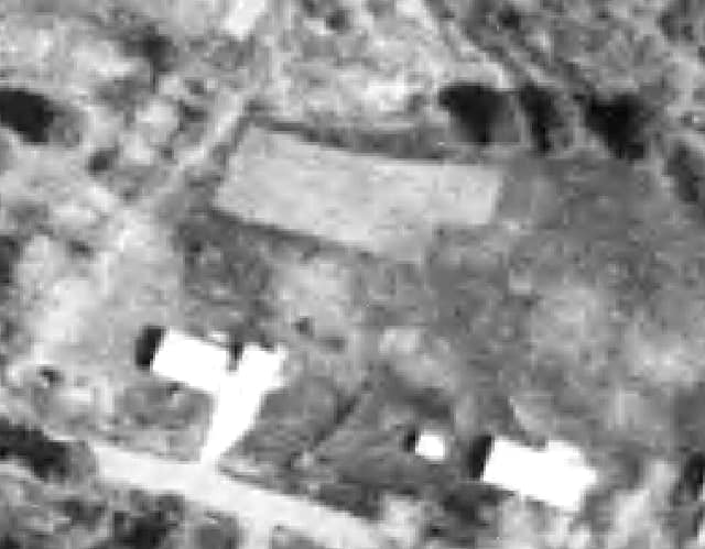
A portion of a 1994 orthophoto from the Vermont Center for Geographic Information (so, naturally, grid north is at the top of the image):
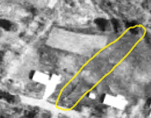
The same photo with the area of interest circled in yellow:
It's my house to the west of the area of interest. The diagonal line in the area of interest near the road is a line of bushes. There is a faint extension of the line which lines up with a called-for monument near the road and an un-called for monument at the northerly end of the area of interest. The deed line would be around 15 feet west of the, dare I say, occupation line. Perhaps some of the members will know what the faint portion of this line might be? Nothing is visible on the ground today. (Approximate location 43?ø38' 32" N, 73?ø 07' 23" W)
Humor: the hexagon near the top of the photo is a large garden, partially over a leach field. Owner at the time reported to be a retired farmer who downsized.
It almost looks like a trail to me. Are there any old ruts in the woods to the north? Check out the historical imagery on Google earth too. It shows up on the 10/2011 imagery. Also, is there any depression or small ridge visible in early spring before the grass grows?
Edit, that's a nice area. I surveyed on top of the mountain a few years ago.
Gregg
GMPLS, post: 445642, member: 8404 wrote: It almost looks like a trail to me. Are there any old ruts in the woods to the north? Check out the historical imagery on Google earth too. It shows up on the 10/2011 imagery. Also, is there any depression or small ridge visible in early spring before the grass grows?
Edit, that's a nice area. I surveyed on top of the mountain a few years ago.
Gregg
The trail, or whatever it was, does not continue into the woods (a walker would have to ford a brook, walk through a marshy area, climb and climb an 8 foot bank). No noticeable depression or ridge in spring. I'll check out the Google Earth historical images. Thanks.
I'd consider overlaying early atlas maps of Castleton Town on modern aerial orthophotos to see if that is possibly an old road. An old road would be my first guess on that one.
http://www.historicmapworks.com/Map/US/4930/Castleton+Town/Rutland+County+1869/Vermont/
Do you have online maps that you can turn on hill shading?
We do here and the extra information that miraculously appears is awesome.
Ours is from Lidar data.
Grab the lidar data, use a demo of global mapper or Fugro viewer. Isolate ground points, create model, see if it is a trail.
Kent McMillan, post: 445711, member: 3 wrote: I'd consider overlaying early atlas maps of Castleton Town on modern aerial orthophotos to see if that is possibly an old road. An old road would be my first guess on that one.
http://www.historicmapworks.com/Map/US/4930/Castleton+Town/Rutland+County+1869/Vermont/
I haven't tried an actual overlay, but I have visually compared the suggested map to the area of interest and it doesn't seem to be an old road. (I've also been searching the land records, trying to find when the road to the west, Grandpa's Knob Road, was established. Lots of practice reading 19th century handwriting, but no luck so far.)
i guess one of my initial thoughts was something along the lines of a homemade drainage swale that's been re-filled.
nothing evident in 1957 (like an old road). you got lucky and are right on the edge of photography from then:

spledeus, post: 445753, member: 3579 wrote: Grab the lidar data, use a demo of global mapper or Fugro viewer. Isolate ground points, create model, see if it is a trail.
I am not familiar with the suggested software but have used the interactive map viewer provided by VCGI and turned on the lidar layer; I didn't see anything remarkable.
flyin solo, post: 445789, member: 8089 wrote: i guess one of my initial thoughts was something along the lines of a homemade drainage swale that's been re-filled.
nothing evident in 1957 (like an old road). you got lucky and are right on the edge of photography from then:
I was also thinking it could be a swale.
It could be a brush hog pass along or aside the boundary.
ashton, post: 445791, member: 422 wrote: I am not familiar with the suggested software but have used the interactive map viewer provided by VCGI and turned on the lidar layer; I didn't see anything remarkable.
I have not yet figured out how to turn the IMG to a real file with the VT Lidar Download (I just looked at it this morning). I presented a bit on Fugro last December http://www.ese-llc.com/vsls for the Round Tables. I will be back this December to bore you all with a similar run using Global Mapper. Then hopefully I will go skiing.
spledeus, post: 445830, member: 3579 wrote: I will be back this December to bore you all with a similar run using Global Mapper. Then hopefully I will go skiing.
Spledeus,
You ought to invite Mike Childs to your meeting 😎
https://www.linkedin.com/in/michael-childs-87a45712


