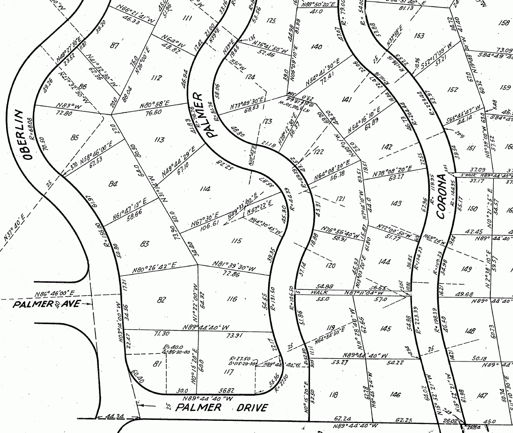
This survey was one of the most interesting ones I have done. It concerns the common line of Lots 114-115 and Lots 83-84.
The client had a need to have the rear line of her lot re established but that was not as easy as it appeared to be on paper. There were some problems that needed to be addressed before the line could be surveyed.
The parent tract was created in 1923. Interior lot monuments and centerline monuments were never mentioned on the tract map. This does not mean that they were not set, but from my experience, what would have been set would have been 2" x 2" hubs.
The area is hillside and has a reputation of being a surveyor killer. A lot of surveyors will not take a job in this area. It's the "Adams Hill" area of Glendale.
The City of Glendale had never, according to their filed records, done any work for centerline perpetuation for Palmer Avenue that heads Northerly from Palmer Drive.
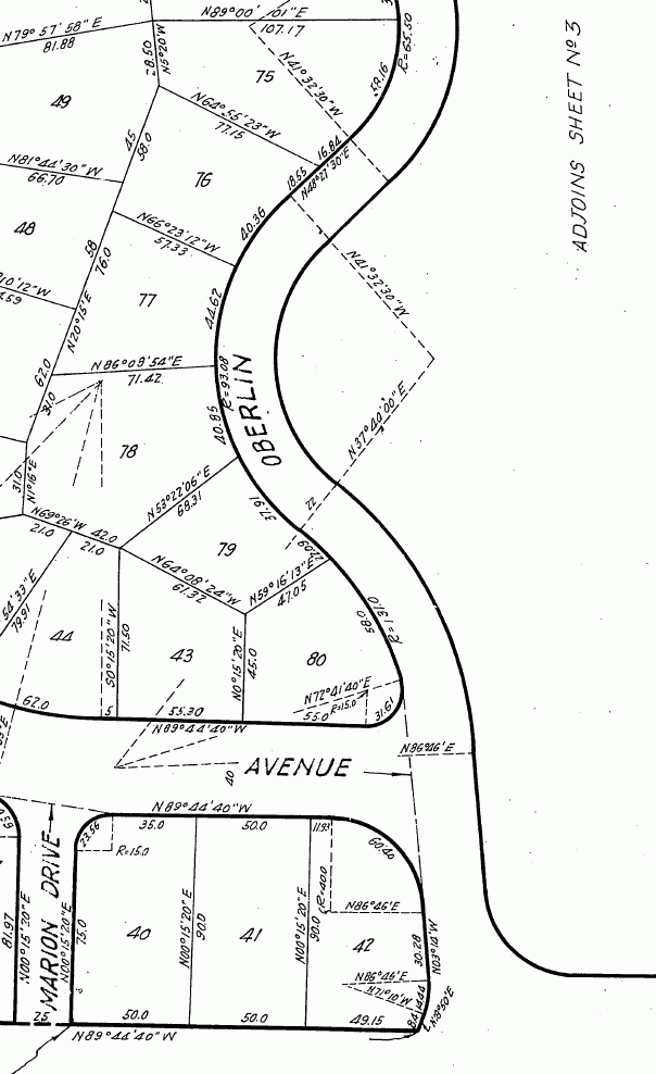
The 1923 tract has a scriveners error at a PRC. On one sheet of the tract map it shows a street width of 22 feet.
22 Foot Width
On another sheet of the tract map it shows a width of 25 feet.
25 Foot Width

A city monument at this location is out of whack by 2.4 Ft.
Lots 80, 85 and 86 and lot 119 do not close. I am not talking hundredths or tenths, it's in feet. All these lots have an impact on the survey.
Survey Area - Sheet 2 of Parent Map

Survey Area - Sheet 3 of Parent Map

Searching for rear lot corners in each of the properties was just out of the question, it cannot be done without a tremendous amount of time and scheduling to do so. The only way that a solution could be Mathemagically produced was to recover what was available for front lot corners or offsets and any centerline control and come up with a reasonable analysis using that information.
What is shown on the RS is not cast in stone. It has been created as a base map for following surveyors.
The survey ended up having to re establish the common line of Lots 81-87 and Lots 112-117 as well as Palmer Avenue that heads North from Palmer Drive. I do not believe in just doing a Mathemagical Solution without leaving some physical evidence behind, so we ended up setting 11 centerline monuments and 5 private lot corners.
I did not make a financial killing on this one but I did not do the survey for the money, I did it because it was an area that needed some serious survey work done and a record filed on that work.
Parent Map Link
http://survey.dpw.lacounty.gov/landrecords/Tract/MB0091/TR0091-025.pdf
Mathemagical Link - Courtesy of Beerleg
Paul - I don't see any occupation lines on the survey except the one point you set on top of the wall. I may have missed some. Did you consider them irrelevant to the locations of the lot lines as originally surveyed?
> Paul - I don't see any occupation lines on the survey except the one point you set on top of the wall.
You wont see any occupation lines on my surveys unless a line is established by occupation.
>Did you consider them irrelevant to the locations of the lot lines as originally surveyed?
Not at all. I have survey monuments to re establish from. I'll leave the walls and fences for other surveyors to fumble with. I'll stick with surveyors monuments that have a history and acceptance by other surveyors who dont hold fences/walls/tree lines and mow lines as boundary evidence.
As an aside...
I wonder how many surveyors consider surveyors monuments irrevelant when they find a wall/fence/mow line?
You say "Not at all" but it seems like your answer is "Yes". I'm not saying you should hold fences/walls/mow lines over monuments and math. It's your call. However, in a subdivision with all those math errors, it would be interesting to see how your conclusions and the record data matches up with occupation lines. I know this is not a news flash to you, but a lot of times the fences were built and perpetuated from points set by the original surveyor.
Around here, if you don't show fence ties, the map checkers will ask for them. You can say "No", of course, but we kind of get used to doing it.
On that problem survey I talked to you about a few weeks ago, I came up with a dozen different mathemagical solutions trying to find one that would match the back fence corners which are the exact record distance apart. Finally, I said "Screw it" and held the fence corners. The property owner paid a lot of money for me to tell him his fences were the property lines, but that's the way I saw it.
Mow line?
That makes me giggle.:-D
Roadhand
You're easily amused. I myself have not reached the depths of Schautianism that would determine a boundary from a mow line, but when the maps and monuments are ambiguous and I get a pattern of fences that conceivably could have been placed according to the original surveyor's stakes, I at least consider them as evidence.
good job
> On that problem survey I talked to you about a few weeks ago, I came up with a dozen different mathemagical solutions trying to find one that would match the back fence corners which are the exact record distance apart. Finally, I said "Screw it" and held the fence corners.
Steve..we survey in different worlds. I remember that survey we spoke about. When different surveyors come up with different locations for the same point all thats left is occupation.
The rear line actually fell in very well for my survey. There was an old wall that was originally protecting a garage from a down slope that I hit within an inch or so from it's east edge. The owner of that garage decided to expand his yard (without benefit of a survey) and placed another wall 3FT or so over line.
The rear lines of the Lots land on down slopes, so a lot of that area has not been improved upon.
I consider occupation on all my surveys, I never consider it as being irrelevant. It has a place, but for this survey it did not.
gardner
I have never had an appelate court judge refer to my work as a 'bogus survey' and I understand that you cannot grasp the meaning of your state laws ss 321-325 so you might want to pay more attention to advice from your 'betters' instead of perpetuating your ignorance.
Richard Schaut
Schaut
Take your meds..
Get off
your "High Horse" Richard.
Amazing amount of info on that plat, Paul. I hope that area surveyors in the future do their due diligence and use your obviously well prepared, calculated and drawn plat. I could do the same thing here (sort of) and it all go for naught because some landowner wouldn't want to record it... I can't record without their signatures... *big sigh*
Thanks Carl..
Like I said, this survey is a base map for those following. I do not expect my numbers to stay the same when another surveyor works that area. I also know that the rear corner values will most assuredly change when someone is able to have access to the rear of any of those lots and recover a previously set corner monument. In some cases, established occupation may overrule my work..
The object was, and always will be, to provide a record that others can rely on.
BTW..I do know that 0.04' is floating on Palmer Avenue (North) from Oberlin Drive..but that's really not much of a concern to me 😀 I found it during a control check..
I might add that if I was to survey any of the lots on the RS I would hold my values until I found something (rear corners..occupation lines) that would change them.
sir, that plat is a sight to behold
Steven
>I know this is not a news flash to you, but a lot of times the fences were built and perpetuated from points set by the original surveyor
Sure is not a news flash, nor is knowing that people build without any knowledge of where the property line is and they also build to C/L swing ties thinking those are property line markers...Not a news flash for me
An attorney once placed an injunction on a construction project. He did a site visit and saw a lead and nail in the curb that differed from the line of the construction and the injunction to halt construction was placed.
The lead/nail was a city swing tie. It was 'gently' explained to the attorney what it was and the injunction was lifted and the construction proceeded to completion without any more interference.
Nope..no news flashes about people building in error and others building using original monuments. It's being able to tell the difference between the two that is important.
Steven
we don't have swing ties or tangent ties for the most part up here.
We are lucky to have anything at all in older neighborhoods.
Thanks Moe
I'm suprised that no one has called me on the rejected monuments 😛
> Thanks Moe
>
> I'm suprised that no one has called me on the rejected monuments 😛
Didja pull em? 😉
> Thanks Moe
>
> I'm suprised that no one has called me on the rejected monuments 😛
Oh, I saw them. And, I have rejected stuff too.
Butch
> Didja pull em? 😉
Better...documented them and sent a copy of the RS to David Hobbs 😀


