
Activity Feed › Discussion Forums › Strictly Surveying › Well, At Least They Didn’t Destroy It…
Well, At Least They Didn’t Destroy It…
Norman_Oklahoma replied 2 years, 4 months ago 18 Members · 31 Replies
 Posted by: @jaccen
Map of some examples: https://www.richmond.ca/__shared/assets/BenchmarkMap21730.pdf
Loving those elevations. At least those are meters and not feet. When I was a student at BCIT we were assured that, one day, Richmond would be flooded off the map.

@mark-mayer
If I remember correctly, BCIT had one of these buried HCM’s near their front entrance that we tied into.
Some Dutch and Bayou people would wonder what the fuss is about for those elevations 😉
It does serve as a reminder to check your surroundings. We had an engineering firm gives us plans and the elevations were all out by less than a 1m. We could not determine what vertical datum they used as it did not match up with anything in the area, nor was anything declared on the plans. We asked for the source of the drawings. It was a survey done by a small freelancer where they had done a typical 10000,5000,100 starting point and then just traversed around. Nothing wrong with that–it just wasn’t properly documented. The engineering firm had rotated/moved it so that it lined up with Google Earth. The problem was that it was down near the lake where the elevations were around the 100.00m mark. So the vertical seemed to line up, but it was just a coincident. The lack of documentation could have proven a hassle had things not been caught off the hop.
 Posted by: @jaccen
Some Dutch and Bayou people would wonder what the fuss is about for those elevations

Those people would find such elevations common, but they would not likely wonder about their significance.
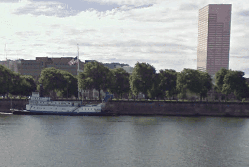
In 1995 the Willamette River through downtown Portland flooded to within a couple inches of the top of that seawall. Such a rise in the Fraser would put the entirety of Lulu Island under water. The Willamette has dams to control the floods, the Fraser does not. It can happen. Probably the proximity of Lulu to the open ocean is the only thing saving it. But that puts it in Tsunami danger from the other direction.
@norman-oklahoma
Very true. The rest of the province also has enough water issues to deal with currently.
- Posted by: @jaccen
The rest of the province also has enough water issues to deal with currently.
When I lived in Canada, it was (mostly) in Abbotsford. Sumas Prairie (fka Sumas Lake) has flooded before. Not that that makes it any less of a disaster for the people involved, but just that it is part of the natural order of things. For that reason the houses are built with their main floors well above ground level. It will happen again, someday.

@norman-oklahoma
Oh, the things we can learn by following this site. I was curious as to the location of Abbotsford. This, in turn, led me to search for Sumas, Washington, its neighbor to the south. That led to the following note mentioning surveyor error. How about that?
Due to a surveying error, part of Sumas lies above the 49th parallel and is thus the northernmost incorporated place in the contiguous United States.
 Posted by: @holy-cow
@norman-oklahoma
This, in turn, led me to search for Sumas, Washington, its neighbor to the south.
Posted by: @norman-oklahomaSumas Prairie (fka Sumas Lake) has flooded before.
Due to a surveying error, part of Sumas lies above the 49th parallel and is thus the northernmost incorporated place in the contiguous United States.
FWIW,
85% of the town flooded this past month…
-All thoughts my own, except my typos and when I am wrong.Read about the flooding there and all over the Sumas Prairie (fka Sumas Lake). Over 1100 homes. Building there is probably as smart as building in the middle of a forest where no controlled burning has been conducted in a few decades. It’s just a matter of time………………………………….
- Posted by: @holy-cow
Read about the flooding there and all over the Sumas Prairie (fka Sumas Lake). Over 1100 homes. Building there is probably as smart as building in the middle of a forest where no controlled burning has been conducted in a few decades. It’s just a matter of time………………………………….
It is extraordinarily rich land for dairy farming in the low lying areas and growing berries on the uplands. The other day we were talking about 4 acres, 100 acres, per cow. My Dad and his wife have 10 acres in the area, they rent out a quarter of it to a fellow who keeps 3 cows on that 2-1/2 acres. And they could feed and water more if they confined the cows and grew hay instead. No shortage of water. You could make a go of it growing vegetables on 5 acres in that area, except the fact that the property values are probably $200k/acre.
 Posted by: @norman-oklahomaPosted by: @holy-cow
Read about the flooding there and all over the Sumas Prairie (fka Sumas Lake). Over 1100 homes. Building there is probably as smart as building in the middle of a forest where no controlled burning has been conducted in a few decades. It’s just a matter of time………………………………….
It is extraordinarily rich land for dairy farming in the low lying areas and growing berries on the uplands. The other day we were talking about 4 acres, 100 acres, per cow. My Dad and his wife have 10 acres in the area, they rent out a quarter of it to a fellow who keeps 3 cows on that 2-1/2 acres. And they could feed and water more if they confined the cows and grew hay instead. No shortage of water. You could make a go of it growing vegetables on 5 acres in that area, except the fact that the property values are probably $200k/acre.
Is this the same area that was previously a lake and wetlands before it was drained a century ago?
https://en.wikipedia.org/wiki/Sumas_Lake
Explains why it is so fertile but also flood prone.
Willy- Posted by: @williwaw
Is this the same area that was previously a lake and wetlands before it was drained a century ago?
The same.

Log in to reply.