
Activity Feed › Discussion Forums › Strictly Surveying › Trimble Access duplicate point tolerance bug
Trimble Access duplicate point tolerance bug
350RocketMike replied 1 year, 5 months ago 11 Members · 67 Replies

I’m given a combined scale factor which I can use if running TS only, but it fits almost perfect with just selecting our UTM zone, nad 83 and the local geoid. Some jobs are site calibrated instead and some older jobs are scale 1:1, which means I can’t use my vrs rover (I don’t have a base).
This is an area I need to spend more time researching just to have a better understanding.

@350rocketmike it is so hard to find time for sure. I believe we are all in the same boat. I have been trying to finish some training for safety since 530 am this morning. But instead i have been computing data. And reviewing a rtk survey for drone control that someone else did. And it should have been 15 minutes. But first issue. The claim one datum nad83 but input itrf position next no geoid file used so ellipsoid and elevation are identical. Not a big deal easy to fix. But they put in and held a orthometric height in ellipsoid height field I assume. So even that is off. Somehow when u find one mistake more start popping up . So i find bad base station antenna heights and rover antenna heights changed every time the took a shot. Same numerical value on most but different point of measure up to. I don??t even know who did the work it was not us. My boss just asked me to review it and see if i could verify if any issues would arise . My list kept growing and he just said ok you can stop i will get the answers for you from the client.
the other is I keep being told to just let a least squares adjustment fix everything. Good grief. Least squares doesn??t fix bad data BLUNDERS. Why can??t people get that through their brain housing group. I want to find the person that started all that talk. It is a awesome method. It gives us the ability to find poor data or blunders we might have missed indicators. It allows us to easily get the best fit of our bounder free data observation with confidence. But it doesn??t flat out eliminate bad data. Sorry for my rant lol. Hope all the ideas here help you figure out your issue. Now back to computing for me lol maybe just maybe i will have time to finish my training lol.

yeah, training with a real surveyor that’s used it too. I was all stoked to get weeks of training with Trimble and with MicroStation and now I’m using the Leica stuff, it’s been a real challenge for me. almost as difficult as the FS studying…..silly lawyers make this happen to us…. Intellectuall property aside, it shouldn’t be that hard to do, yet it is…..
THRAC OVER
Sounds like someone was drinking on the job to make that many mistakes. I know I make mistakes, but most I catch before they get anywhere.
Just finished up some as builts with another party chief and his tsc7 is also auto averaging without prompting. Had a reflectorless shop miss the corner and tried it overwrite it and it just averaged the second shot.
One thing I learned is with multiple observations it’s quicker to delete from the map screen directly than going to point manager and deleting individual observations.

it is so hard to find time for sure. I believe we are all in the same boat. I have been trying to finish some training for safety since 530 am this morning. But instead i have been computing data. And reviewing a rtk survey for drone control that someone else did. And it should have been 15 minutes. But first issue. The claim one datum nad83 but input itrf position next no geoid file used so ellipsoid and elevation are identical. Not a big deal easy to fix. But they put in and held a orthometric height in ellipsoid height field I assume. So even that is off. Somehow when u find one mistake more start popping up . So i find bad base station antenna heights and rover antenna heights changed every time the took a shot. Same numerical value on most but different point of measure up to. I don??t even know who did the work it was not us. My boss just asked me to review it and see if i could verify if any issues would arise . My list kept growing and he just said ok you can stop i will get the answers for you from the client.
Wonder if the control folks were surveyors. A not-insignificant chunk of us still sees themselves as data collectors and regurgitators. Punch it into the magic machine, pull the lever and export the result. What’s ellipsoid height? I don’t care, that stuff is for nerds. Something something follow the footsteps, hold the monument, blah blah blah…
The successful surveyor of the future will be able to get down and dirty with the hardware and software, as well as understand the transformations and equations that make it tick. The big-ticket clients of the future aren’t going to want PNEZD CSV as a deliverable.
the other is I keep being told to just let a least squares adjustment fix everything.
WTF. This is why we either need more rigorous licensing exams or four-year degree requirements. I’m pretty sure I heard “LSA doesn’t fix bad data!” at least once a week throughout the required 4 semesters of statistics and spatial data adjustments.
If someone doesn’t understand what LSA is for and what it does, they shouldn’t be using it or directing folks on how to use it.
“…people will come to love their oppression, to adore the technologies that undo their capacities to think.” -Neil Postman“LSA doesn’t fix bad data!“
I want this as a T-shirt, trucker hat, and a coffee mug. Hell bumper stickers for the win!
????

If someone doesn’t understand what LSA is for and what it does, they shouldn’t be using it or directing folks on how to use it.
OR… hear me out: just export a .csv from your data collector and import it directly into CAD. No adjustments = no worries
EDIT for all of those that don’t know me: the above statement is complete sarcasm. PLEASE collect enough data to be able to analyze/adjust your work.
@rover83 I am so with you. I am not a big pusher of a 4 year degree but i will have to say the 144 hours of bs and ms level courses even the tech school courses did not hinder me in learning. But i do have a big belief in higher education. I just believe it can be obtained many ways. I honestly believe we went through some phase or trend that has multiple aspects. One we pushed and mentored the drafters to get licensed and left our field people as mules. And i can count many ls folks that i worked with or know personally that never surveyed in the field over 40 hours in their whole career. Now they are not dumb some have degrees. They if i asked would probably sit down and train me in cad tomorrow. Many over the years have reached out to me when they got themselves in a jam especially with gps. I am not licensed. But they respect me enough to ask for help. Along with that we also become so busy and equipment so easy to get an answer (not always correct answer) that we never taught them what it was doing in the data collector. And we created button pushers. I literally had to add a distance to one point today to raise an elevation for a field guy. Not because he didn??t know how because of our work flow required that have been passed down. He is doing what he was told. That??s not what i want to do. That??s my biggest frustration coming back to private sector. Is that the first reaction is to call office. Before our last resort was call the office. Times change. I have dug out one of the old Trimble gos basics book for rtk. Like 1990??s book. A little science a little math and basic explanation of how rtk works. I have it ready for one of my new crew chiefs. He is a bright young man smart great attitude. Listens. He has just used rtk and never told or taught what is going on. If the dc sais its good it is. I started discussing rtk with him and figured out he had never heard terms like common satellite at base and rover. Why I wanted 180 epochs on certain points. Interger ambiguity etc etc. he will be way smarter than i am or i will ever be. I will teach him everything i know. He will probably outperform me in know time. I love it though.Always make people better than you are is how we make things better.
As far as LSA fixing bad data. I have heard that more in the last couple years than ever before in my life. I don??t know where it comes from.
I will say the company i am with now does a lot of mentoring and teaching compared to where i left. That is awesome to see. Good mentoring at headquarters level. Really trying to have the most skilled and educated field folks. I have not heard one complaint about my time sheet on overhead of an hour here an hour there stating teaching john doe about this or that. We are just so busy keeping up I can??t implement a training program. I would like to once a month take a half a day and have a small class. Incorporate what the data collector is doing with how to long hand and the theory behind it. It will probably never happen. But i am getting to take one of my young chiefs out me and him to set up a job for a boundary and really try and show him evidence beyond just a monument rebar. I did the survey next to it and several natural monuments were called out on a line. Blazed tree. Stream crossing and along a creek bed. All in deed or plat. The monuments are in but the distance do not match exactly but it was done with transit and chain. All evidence that needs to be observed. So a LS has eyes on it so to speak. Steep terrain also probably why distance are not that good. But not that bad either. I begged to go out and just help point them out. He is smart but he has mostly been in city type work so i am hoping to help him up his game a bit. When I started i had LS doing this. Coming out and if for only a moment walking the lines and pointing out things and explaining why. Now i just wish I could remember all those old crusty surveyors taught me. Lol. Some of it comes back and some gets all jumbled up in my head.
the company i mentioned above is not our company its a different one and they need assistance lol.

I’m given a combined scale factor which I can use if running TS only, but it fits almost perfect with just selecting our UTM zone, nad 83 and the local geoid. Some jobs are site calibrated instead and some older jobs are scale 1:1, which means I can’t use my vrs rover (I don’t have a base).
This is an area I need to spend more time researching just to have a better understanding.
Assumption: I am presuming that you are pinning residential houses.
Question: Is your firm scaling down all the houses so that they fit your sub all on grid?
I ask because this has been common in my experience for larger projects (ie. highways, railways, etc.), but the majority of the work I have done for residential dwellings has all been in ground. Typically, it is per M-plan with a grid factor chosen, roughly, in the middle of the sub. Or do you have enough adjacent subs that it is worthwhile to do everything in grid? Just curious as to the reasoning as to why to do everything in grid for residential pinning. For the record, I am not saying one way is right or wrong–just curious to the mindset. I have not worked for a firm in Canada that uses LDP’s so I will not address that.
Or are your concrete crews/framers good with “good enough” (ie. ground dimensioned building is placed within a grid distance lot)? Most of the municipalities down here (SW ON) would not be able to wrap their mind around the idea of a lot grading plan done with grid distances IMO. Again, just interested in the background info that brought that decision to the forefront.
I’m given a combined scale factor which I can use if running TS only, but it fits almost perfect with just selecting our UTM zone, nad 83 and the local geoid. Some jobs are site calibrated instead and some older jobs are scale 1:1, which means I can’t use my vrs rover (I don’t have a base).
This is an area I need to spend more time researching just to have a better understanding.
Sorry, just chewed over your response a bit more. You can use a VRS rover for a ground sub. We do it all the time here in SW ON. PM me if you want to exchange cell numbers to shoot the poop on it for a bit. I presume you are on Smartnet per the VRS statement? We are currently using Topnet and Carlson, but the fundamentals are similar.
Some older jobs are scale 1:1, which means I can’t use my vrs rover (I don’t have a base).
I agree with @jaccen, VRS doesn’t preclude site calibrations for local coordinate systems. It’s just like setting a base up over an arbitrary point and getting a here position, then tying points with the rover for use in the calibration.
Definitely a problem if there aren’t enough points to calibrate to, though.
I am deep in VRS-land, and even though it’s a great tool there’s a ton of misinformation and incorrect procedures floating around…
“…people will come to love their oppression, to adore the technologies that undo their capacities to think.” -Neil PostmanSorry I meant when site calibrations aren’t a good option. We use cannet which is Trimble only.
Also these are usually subdivisions that have been around a few years and already have lots of houses in them. In some cases I might be able to consider a site calibration as long as I can get good checks to existing building ties, but often it would take less time to set on some existing control and traverse to where I need to be.
Yes this mainly all small residential houses in large subdivisions. The houses are usually just ground distances even if the rest of the job is in grid, these are very small houses on small lots. And the better formers can often get the corners of the walls within 0.015m
The reason they’ve been trying to keep all the newer stuff in grid is so we can replace control when it constantly gets destroyed, without spending an hour or 2 doing a site calibration to get set up again.
Just finished a backsight and put the mt1000 back in the truck and drove back to where the layout is, “target locked…no target… target locked…” the whole way up the street….so I figure “damn the switching back to passive bug has returned”…back into the settings…what do I find? Still in semi active right where I set it when I went to backsight. So why did it lock onto the truck?
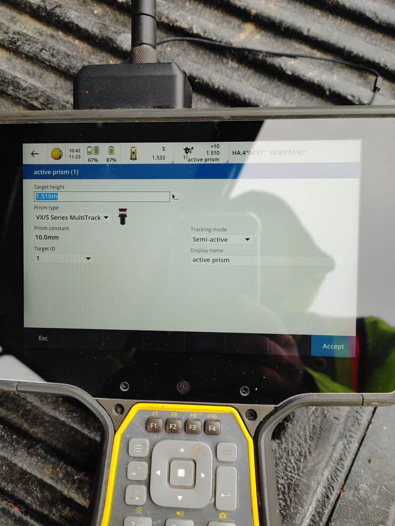
Edit:
I don’t think it was actually locking on anything. I discovered shortly after access had slowed down to a crawl… so it was likely about 10-20 seconds behind with its verbal diarrhea as I drove away. It probably lost and gained the target a couple times as I put the prism in the truck so it was just behind.
And since I know someone will bring it up…I booted the collector up from completely off when I first got here. I don’t leave it on all day or for days like some guys do. It’s likely a wonky DXF that’s causing the lag here.
Normally the speech only lags behind by about 2-4 seconds under normal conditions.
So why did it lock onto the truck?
Where was the prism in the truck? Was it in a location where the LEDs could be seen by the instrument? Reflected off something?
When the MT1000 battery is good, it’s turned on and set to the correct ID that matches the one in Access, and the diodes are all in good shape, I’ve never – not once – seen it actually lock onto anything BUT the MT1000.
I’ve seen it lock onto the prism’s reflection in still water before, but never something that is not the prism.
“…people will come to love their oppression, to adore the technologies that undo their capacities to think.” -Neil Postman
Edit:
I don’t think it was actually locking on anything. I discovered shortly after access had slowed down to a crawl… so it was likely about 10-20 seconds behind with its verbal diarrhea as I drove away …
Normally the speech only lags behind by about 2-4 seconds under normal conditions.
Are you running speech output ALL THE TIME?
That could be half your problem. I know EVERY machine I’ve ever dealt with using speech output, and I’ve dealt with alot(my wife is totally blind) runs alot slower. Try turning off the speech, or at least adjusting the verbosity.
Point taken. I will turn it off. Only reason I leave it on is sometimes it’s useful. Unfortunately Trimble doesn’t give any options to adjust it. On/off and adjust the volume. I would like to turn off the broken “Go left!” When you need to go 20 meters out and 0.050 left. Seriously?

Sound on the controllers can be quite delayed, and they can get queued up for ages. Unfortunately it is an operating system thing – Access says ‘play this’ and the system gets around to it when it can – and sound is usually a low priority system process.
The top line of the display is your best measure of what is going-on right now. It gets updated by Access as high-priority real time. If you don’t see that padlock you’re not target locked, simple as that.
For me, the only time the sounds are useful is through a set of blue-tooth earmuffs when setting out on noisy construction sites. Then the ‘go left’ ‘go right’ mean I can concentrate on the prism bubble, not the controller so much.
I do like having the controller vibrate when it stores a point.
I definitely pay more attention to the screen than the sound, but I have tripped and fallen in a couple of holes trying to watch the screen (usually with GPS when I’m trying to see if I am headed in the right direction). Why did Trimble leave out the “go in” or go out”, it’s always left or right, even if it’s 200m out.
I do like the vibration when the observation is stored though.
One of the times I want the sound is if in shooting control or a corner with GPS and I try to do something else while it’s shooting…. I’d like to hear “poor pdop” as a heads up when things start to go bad.

Log in to reply.