
Activity Feed › Discussion Forums › Software, CAD & Mapping › Triangulation from TS / theodolite data
Triangulation from TS / theodolite data
bill93 replied 2 years, 6 months ago 23 Members · 34 Replies

The real good software for what you want to accomplish is in the IPhone 12. You can model your whole room in just a matter of minutes. LIDAR

Do you have to consider the origin of your coordinate system in order to use commercial software? I don’t know, so I’m asking.
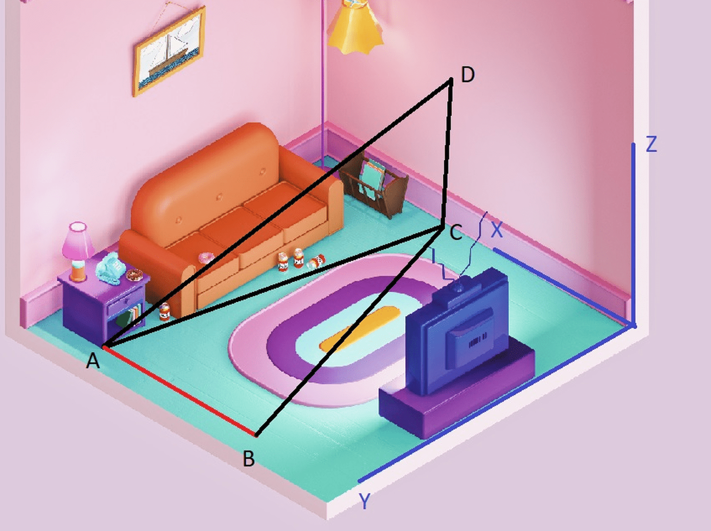
For example, if we use Homer Simpson’s living room as a model, the blue colored axes would form a right-hand coordinate system with positive X east, positive Y north, and Z up. If Point D is to have coordinates determined, then Angle BAC is not the azimuth.
Perhaps you just assign (0,0,0) to Point A and go. What should you do if you want to use StarNet, for example.

I’m not qualified to answer, but I think some software may want “true” coordinates (ECEF or whatever) to correct horizontal distances for earth curvature, and report heights as required (against geoid/ellipsoid) ?

You could do it in Cad or build a spreadsheet Triangulation (surveying) – Wikipedia


@thebionicman I just completed the entire course last week from MicroSurvey. Where has this been in all of my career?! I’ve worked at many companies and not one of them used Star*Net. I’m using the heck out of now for these USACE dam trilateration surveys.
@david-kendall Google Iphone 12 Lidar there’s all kinds of information on how to use the lidar scanning function of the phone. It won’t help with your calculations, but if you could get your hands on an Iphone 12 pro you could model your room very accurately in just a few minutes.

Just plot out the point from every traverse onto a CAD layer. Create a block for each set of points so that you can move/rotate them as a group. Move/rotate each set to coincide with the next set to coincide with the common points.

It has been a long time but on that Wild the on board software can do this I don??t remember how. I can??t remember if it would do the vertical though. Or wild soft or Terramodel or cad with the manual commands to enter hz angle like a field book. And vertical or za ht of instrument rod etc. It can be done and height carried in Terramodel for sure. I use to do 3 point intersections for 3d comps. Possible to input manualy into many surveying software platforms. NGS tool kit might help. Excuse the grammar and spelling. I don??t have my glasses and my thumbs are huge on this phone lol. I probably can dig out a comp sheet we used back years ago and you could input the formulas into excel and do it.

I think that by measuring the angle only, the distances cannot be calculated, and the horizontal distances must be measured with high accuracy to correct the travers.
- Posted by: @olemanriver
It has been a long time but on that Wild the on board software can do this I don??t remember how.
The TC1000/1600 etc are very limited in the COGO they can do onboard. Resection, staking, that’s about it…
@fenugrec TC. I apologize T1000 is what I ran. It was not COGO it was like SAS routine or something like that as long as you set it up correctly. But it has been years for sure. Lol. My brain gets confused sometimes. I always liked a 3 point intersection when triangulation was needed especially if I wanted a vertical element in it. Two points will do it but no redundancy other than maybe direct and reverse angles. With three different points and cranking the angles you get enough data to see the error no matter how big or small. If it doesn??t need to be highly accurate then use a level rod with a few readings and do stadia reduction to get your distance. Three wires and carefully readings should be able to get the distance from the theodolite to the rod with all three wires red to the hundredth to about a tenth of a foot. With a setting at vertical at 90 degrees and another two above or below that at good geometry. The. Its simple math triangle math for the distance and elevation. That might be a solution. With no edm or reflector less capabilities. You could check it between known??s. The simplest is setting scope at 90 like a level. But you can still reduce it without being at 90 degrees in vertical component. Maybe look at stadia topo procedures. I hope this helps and thank you for the correction on TC1000 i read it as T1000. They had top mount edm you could set on them.
 Posted by: @fenugrec
I’m measuring features inside a building, and I’m using an older TS (Wild TC1000) that doesn’t do reflectorless distance. So basically using it as a theodolite.
Reflective tape would allow distance measurements and greatly simplify the data analysis.
.

Log in to reply.