
Activity Feed › Discussion Forums › Strictly Surveying › Static GNSS Survey question

This link explains the analysis strategy of the US NGS used for its submissions to the IGS:
ftp://igs.org/pub/center/analysis/noaa.acn
This describes the models and approaches used in processing. Unfortunately, the links from the NGS web site to the other center analysis strategy reports do not seem to still work. See: http://www.igs.org/about/analysis-centers
This link is to a site related to the unification of vertical datums in Europe. I don??t know in which country you are working but there are significant efforts in many European countries to update and maintain their vertical networks.
https://ihrs.dgfi.tum.de/fileadmin/JWG_2011/VDS_2013_04_Report_to_IAG_EGU_2013.pdf
As for the heights you intend to determine, you might like the summary of various height systems by Prof Sneeuw to be useful see: http://geodesyattamucc.pbworks.com/f/HeightSystemsSneeuw.pdf
HTH,
DMM
 Posted by: @geeoddmike
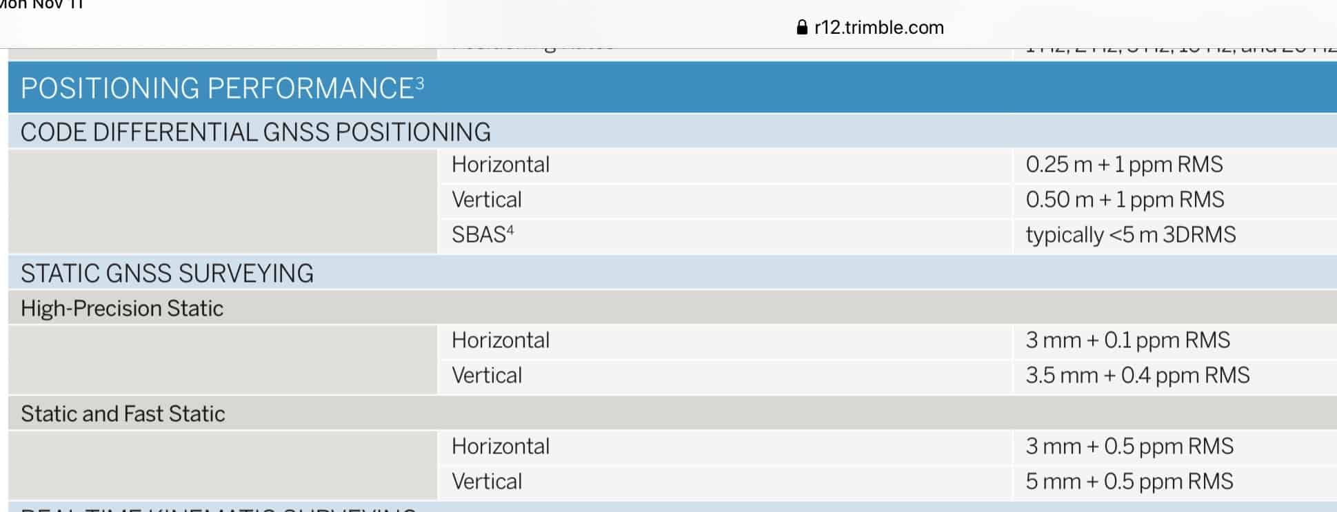
I am always surprised when people quote these base error + length relative error specifications.
First of all, the best of these specification sheets include the proviso that the specifications are under ideal conditions. A good receiver is able to acquire and maintain signal lock and log all SV signals it is designed to do.
So if you consider field work as Non Ideal Conditions then the same specifications still hold true right?

The specifications state the acheivable precision of the receiver. Obtaining that precision requires more than placing it on a tripod and turning it on. Read the fine print:
It also takes more than throwing up a second receiver on another random point. The second receiver does not “act like a second CORS”. Both unknown receivers will still be positioned by the longer baselines to the actual CORS. While you may obtain a precise baseline between them, that will not significantly improve the network accuracy (to the CORS framework) unless, as Mr. Silver stated above, one of the marks is in favorable conditions and the other is not.
“…people will come to love their oppression, to adore the technologies that undo their capacities to think.” -Neil Postmanso do the manufacturer’s specifications still apply or not? I stated that 5mm +1ppm is what he should expect to get. I did not say that you could get 1mm +1ppm or 2mm+1ppm. If he is good with at LEAST 5mm+1ppm then his setup is ok.
Jeez, lighten up a bit.
- Posted by: @geeoddmike
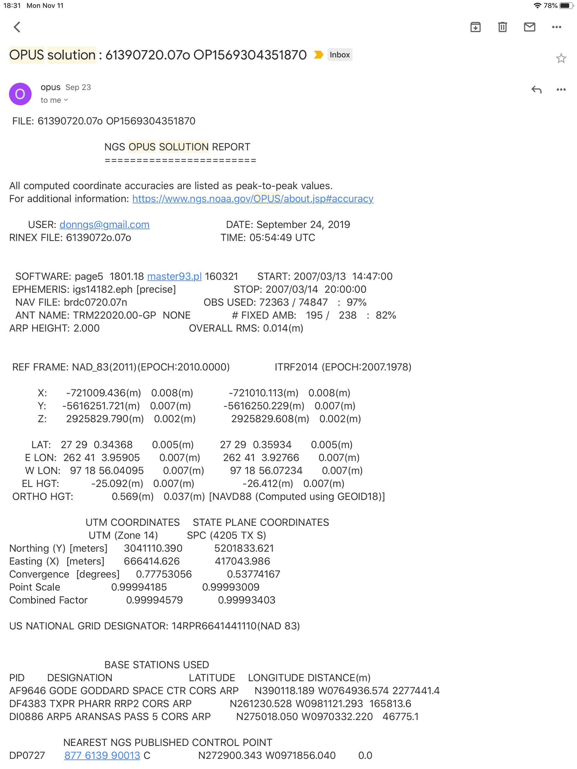
If I take GPS data and process using OPUS first specifying close sites and then processing using distant sites, I do not see a correlation due to distance to the CORS. I see a correlation between length of session and precision.
accuracy of GPS results is dependent on distance from a base to a rover. that’s the reason why every manufacturer’s specification for GPS receivers have the xxmm + xPPM. the PPM is a per millionth factor of the baseline distance. as baseline distance increases, so do the systematic error.
if that were not the case, then everyone on the planet would be using OPUS to process their daily gps data.
Obviously you did not read the Journal of Geodesy article I linked. Nor did you do the simple test of running OPUS solutions with close CORS and the same data with distant CORS. You merely repeat that the manufacturer provides these specifications.
I recently used OPUS with some data I had handy. I chose the CORS for three submissions of the same data. I chose sites to explore how solutions changed with increasing average lengths to CORS. The average lengths were: 136 km, 1,670km and 2,054km. The shortest length was 31km, the longest was 2,227km. My ellipsoid heights for the three solutions were: -25.087, -25.091 and -25.092 (all meters and NAD83(2011).
As pointed out by others, the receiver manufacturers provide caveats to their specifications. I should also mention that the best specification receiver paired with an inferior/defective antenna will give bad results.
Thinking that a GPS receiver works like an EDMI and that errors accrue as a function of distance are wrong.
What does a GPS receiver measure? It is the signal and codes from the SVs to it. (I am talking about static surveying).
How do I measure between two terrestrial points?
1. I place an antenna over each point. Each receiver tracks the SVs in view. Neither receiver communicates with the other.
2. I download data from each receiver and load it into a baseline processor. The data is merged, combined, synchronized and used with models and algorithms to determine the position, and statistics of the determination. The relationship (baseline) between the two receivers is the inverse between the two end positions.
The only reasons distance between baseline ends matter is that there must be enough usable data to confidently solve for the unknown parameters and for short enough baselines I can use an L1-only solution significantly reducing noise and iono effects. Solving for the integer bias unknowns (ambiguities) is essential for a reliable solution.
Why don??t more people use tools like OPUS?
1. Most positioning is done over small areas. Many users want to be as productive as possible and observe very short sessions.
2. OPUS requires dual-frequency receivers/antennas be used.
3. Users like control over the way they process data and are familiar with their software packages which are nicely integrated and easier to use.
4. Many do not like having to deal with OPUS. Completing the data upload form (who knows their antenna model number) is a pain. Nor do they like the way OPUS presents its results. Peak-to-peak error; what??s that?
5. Their data can be used in native format and not require conversion to RINEX.
6. It is not accurate enough for their requirements. OPUS always provides an iono-free solution. Short baselines are in general better solved using L1 data only.
Having started too late and I quit.

Using a manufacturer’s software to process exactly the same satellites over exactly the same times can give much more accurate vectors over moderate distances than using the difference between OPUS static solutions and in much shorter times.
OPUS is for finding where you are in the world relative to a datum. If you have at least two receivers you should work within your project by base-rover RTK or PPK for most accurate results.
.
I can set over a first order bench mark within visual distance of a CORS. The resulting elevation from OPUS or that close CORS point will never even be close to the 5mm +1PPM.
Before GEOID 12 I would expect to be about 50mm or 10 times the accuracy statement, since GEOID12 that “error” has been reduced to about 30mm or 6 times.
Of course the accuracy has little to do with the receivers, it’s a reflection of the accuracy of the model.
So to establish an elevation it’s always best to tie into the elevation system.
I can’t speak to western Europe, possibly they are already shifted to a GEOID model to get elevations, in that case what the OP is doing will work as well as anything with the caveat that it’s more important to get redundancy than long observations times to CORS points that are so close to the site. For me 20 to 50 km from a CORS means the CORS are right on top of me. Measure twice, cut once. Use different receivers and tribrach if possible, measure to different points, get as many measuring sessions and that will validate your point more than a 2 day session when you aren’t over the point or you made a measure up mistake or a data entry mistake.
Write down each element of the session in a field book or sheet, I like to measure in feet and meters, note the times, be sure to track all point numbers, receiver data, ect.
Most “errors” in static networks that I’ve seen were typos.
- Posted by: @mightymoe
I can set over a first order bench mark within visual distance of a CORS. The resulting elevation from OPUS or that close CORS point will never even be close to the 5mm +1PPM.
I’m sure the accuracy spec is only for what the GNSS measures, XYZ coordinates or lat/lon/ellipsoidal height. They have no control over the geoid uncertainty to get to orthometric height.
. 
Sources/resources/pdf/papers recommended for survey/site control methodology for PPK? The majority of the info in Canada relates to RTK and static.
Ie.
I’d be very interested in how US/European federal/state/provincial departments state they want their PPK data created.
A quick Google search brings up a number of articles relating to UAV’s and how the Walther PPK handgun might need a GPS tracker here 😉
Cheers.

This is all getting a little over-theoretical. Apart from the end product being a benchmark, I don’t think we have been told what the purpose of it is.
If the local benchmarks are now unreliable then why is that? If the ground is unstable then the “new” benchmark will also suffer from movement. If its purpose is for a single project only then any minor variation from the geoid is surely not relevant. If it is going to be used in conjunction with other projects then you are assuming that their height determination has been perfect.
The UK recently shifted datums (OSTN02 to OSTN15). I haven’t seen any real problems over the 1-2 cm. change which was involved. The majority of users probably aren’t even aware of the change having occurred.
mmmm, we are saying the same thing.
Our R10 receivers are freakishly accurate, I would say the 8mm +1ppm they state for RTK is a conservative statement.
But that doesn’t mean that the inaccuracies in CORS/OPUS/GEOID Models can be disconnected from surveys done by the receiver. All those add up. That isn’t the fault of a receiver.
And thanks again Bill for doing your bench mark density observations and submitting them, that’s a lot of work.
- Posted by: @jaccen
Sources/resources/pdf/papers recommended for survey/site control methodology for PPK?
I’m not up to date on what is out there, as I’m not in the business.
I’ve recently been doing a project of mapping the family farm land, because the parcels don’t line up with roads and creeks, and want to figure out what a possible replat might look like. For that I use two antique L1/L2 receivers and the demo mode of the old Topcon Tools. It will process the vector between two receivers using only common times and satellites. I think that is called Post Processed Kinetic.
I know that the results are matching up to an adjoining older recorded survey, say at 0.015 ft (0.5 cm), which is better than minimum-length OPUS sessions would. The hard part is guessing whether some of the surveys in the neighborhood give SPC distances or ground distances. They never say. When the bearings match up nicely to SPC and the distances seem to check better as SPC I have to assume they are.
. - Posted by: @geeoddmike
I recently used OPUS with some data I had handy. I chose the CORS for three submissions of the same data. I chose sites to explore how solutions changed with increasing average lengths to CORS. The average lengths were: 136 km, 1,670km and 2,054km. The shortest length was 31km, the longest was 2,227km. My ellipsoid heights for the three solutions were: -25.087, -25.091 and -25.092 (all meters and NAD83(2011).
Can you please upload your RINEX files & let us know what GPS units and antenna were used in your observations? I bet geomatics students & GPS manufacturers would also be interested in your data for their real world research.
As there is nothing special about my observation file and posting a binary file probably problematic, I attach my three OPUS solutions using the same data file but choosing the NGS CORS sites.
FWIW, my assessment of a receiver??s performance would be along the lines of this: https://kb.unavco.org/kb/file.php?id=442

I would go ahead and set your additional point and then you have 5 total points which will give you additional redundancy for both horizontal and vertical stability.


Log in to reply.