
Activity Feed › Discussion Forums › Strictly Surveying › State Plane Coordinate System of 2022

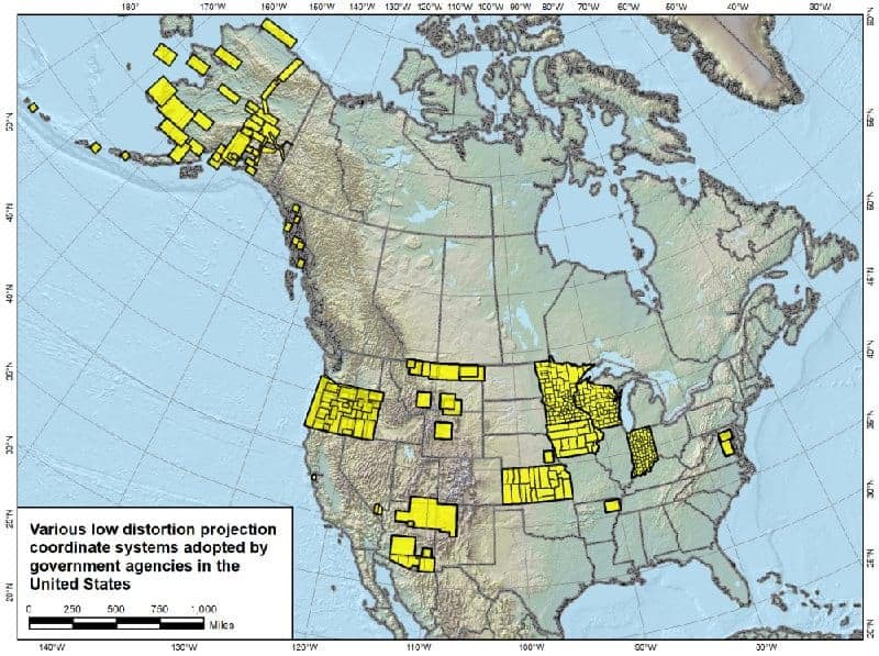
The NGS presentation showed a map indicating that only a minority of states, and a few other jurisdictions, have officially defined LDP systems.
 .
. Posted by: Mark MayerPosted by: MightyMoe
Actually, I believe Mark is saying that special files are available, that isn’t good enough for me..
That’s true, I am. But once 20, 30, or more states have agency defined LDPs I’m sure that they will come installed.
I would like to think it’s a change which is coming. Bill’s map is interesting, not surprising that Montana is making some. It’s interesting that they are near the least distorted areas.
 Posted by: Allen Wrench
I was under the impression that most states had county coordinate systems (LDP’s) already defined by their DOT’s or some government agency. Is Minnesota (where I work) unique in this respect? Are most of you working in states where you’re all up to your own devices, other than the vanilla SPCS definitions?
TxDot uses a surface adjustment factor for each county but it is just TxDot. I have a list for all the counties. Sometime in the recent past, the Dallas district recalculated their counties and have a new SAF that better fits the ground.
I don’t know of any other state agency that is using the TxDot method.
James
 Posted by: MightyMoePosted by: Mark MayerPosted by: MightyMoe
Actually, I believe Mark is saying that special files are available, that isn’t good enough for me..
That’s true, I am. But once 20, 30, or more states have agency defined LDPs I’m sure that they will come installed.
I would like to think it’s a change which is coming. Bill’s map is interesting, not surprising that Montana is making some. It’s interesting that they are near the least distorted areas.
follow the money…..

I would like to think it’s a change which is coming. Bill’s map is interesting, not surprising that Montana is making some. It’s interesting that they are near the least distorted areas.
I might be wrong here, it seems to me that a private contractor configured a bunch of LDP’s for the various tribes in Montana – a system where each reservation has its own custom LDP. Maybe that’s why it’s kind of spotty zones.

Log in to reply.