
Activity Feed › Discussion Forums › Software, CAD & Mapping › Road bearing in subdivision plat different from measurement in satellite map
Road bearing in subdivision plat different from measurement in satellite map
holy-cow replied 2 years ago 19 Members · 31 Replies
 Posted by: @norman-oklahomaPosted by: @lamberwby
It does look like that north and south right of way lines are non-parallel.
I don’t think we can draw any conclusions regarding the parallelism of the RW lines from this plat. It just appears to be carelessly drawn. Note the endpoints of the lines running over.
Maybe that north r/w is actually a meander line drawn of the non-navigable shoreline flow of that gutter, with property lines extending to the thalweg. Can’t see the legend. 🙂
dd Posted by: @lurker
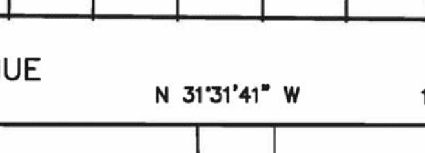
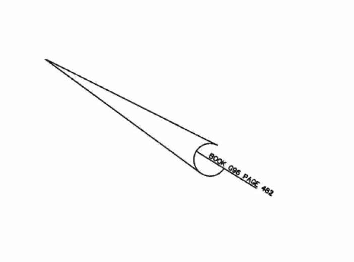
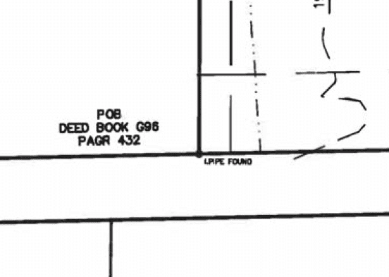
From the notes on the plat it appears he held a bearing from the deed located in book G96 page 482. From the same notes though this survey references a survey that was prepared way into the future in 20015. Perhaps 20015 is not the only typo.

The appearance of a date being in 20015 is startling, but so are the three ways to spell “prepared” plus the appearance of “planprepared” all within the seven items listed as references in the far lower left corner. Boost to at least 200 scale to have a chance of reading that.
For more fun, go to the top right corner, boost to 400 or 500 scale to be able to read the words, then learn this document isn’t worth the paper it is printed upon. Especially note the “ultimate” user(uh, who?) didn’t need no stinkin’ monuments set.

FYI this subdivision was approved with this plat.
 Posted by: @lamberwby
FYI this subdivision was approved with this plat.
This was the final plat? I see a bunch of preliminary/proposed stuff on there. Looks fishy to me.
Top right notes say it’s prepared only for entities in the title cert, but then says no title search was done, which doesn’t track for a subdivision. Not sure how municipalities can approve subdivisions without at least a basic title certificate to verify the purported subdividers actually own the land.
And speaking of that…are there no signatures from the local planning & zoning folks verifying that the lots, setbacks, etc. meet zoning requirements? At the VERY least there should be signatures from the owners declaring that they are subdividing the land (and dedicating new easements or roads, if any).
I’m equally surprised that someone could “waive” setting monuments for a subdivision. Around here they actually send out inspectors to check that have set corners before we are allowed to record short plats, even in unincorporated county areas.
All of the above would make me suspicious of any actual “survey” data shown on the map, including that bearing on the road.
“…people will come to love their oppression, to adore the technologies that undo their capacities to think.” -Neil PostmanThat looks like what we call a Tentative Map, the sketch delivered to the planning department as part of the subdivision approval process.
- Posted by: @dave-karoly
planning department
Exactly. I work for a County Planning Department which approves the subdivisions based these so called sketch plats, and then let the municipality review the final sketch to be submitted by the developers. I am new to my job so I am still learning the workflow of our planning board.
This would not fly in my neck of the woods. Many times there is one sheet with all the verbiage, signatures and certification of signature and the other sheet is the actual plat with all the bells and whistles documented per the 103 page document spelling out what those bells and whistles happen to be.
Also, there is normally a “preliminary” plat which includes data of importance to those signing off on the preliminary plat but which is not to be included on the final plat. Figuring out what is or is not to appear on each plat is an exciting adventure all by itself. For example, a topographic map may specifically be called for on the preliminary plat but not the final plat.
 Posted by: @holy-cow
For more fun, go to the top right corner, boost to 400 or 500 scale to be able to read the words, then learn this document isn’t worth the paper it is printed upon. Especially note the “ultimate” user(uh, who?) didn’t need no stinkin’ monuments set.
The note in the upper corner is required by New Jersey P.L. 2003, C.14(C45:8-36.3) and N.J.A.C. 13:40-5.1(d). This law was pushed through by others in the Real Estate industry when the State Board proposed requiring the setting of corners on all surveys.
The required monuments for the subdivision is controlled by the N.J. Title Recordation Law N.J.S.A. 46:26B-3 in this case since this is a subdivision this supersedes P.L. 2003, C.14(C45:8-36.3) and N.J.A.C. 13:40-5.1(d).
That drawing does not look anything like what a final subdivision plat in New Jersey normally looks like, even for subdivisions which are classified as minor subdivisions. Way to much missing information. Maybe it’s a sketch plat to begin discussions with the Planning Board.
PLS NJ & NY, PP NJ
@dave-karoly PAGR 432!
OK. After studying the view of the sketch and then returning to the original post, my thinking about this has refocused. The question was about the two different bearings cited. That question has been answered. We, however diverted to picking apart the drawing. The bottom line is that the author of the original post has only been supplied with a cartoon. There must be a final drawing showing what has been approved to occur, which is a simple lot split.
The sketch shows the prior use of all of Lot 1, which is a cemetery on the right half and a generally unused space on the left except for a small structure. If we look at the aerial view in the original post, we find that structure has been removed, much dirt work has occurred and something new is in the upper portion of the left half.
The GIS department should be using the final approved plat, not the cartoon.
I am personally appalled that the great State of New Jersey has a law that specifically declares monuments to be unneeded. Thanks to Dan Dunn for pointing that out. See below.
“The note in the upper corner is required by New Jersey P.L. 2003, C.14(C45:8-36.3) and N.J.A.C. 13:40-5.1(d). This law was pushed through by others in the Real Estate industry when the State Board proposed requiring the setting of corners on all surveys.”


Log in to reply.