
Activity Feed › Discussion Forums › GNSS & Geodesy › NGS Datasheet orthometric height discrepancies
NGS Datasheet orthometric height discrepancies
MightyMoe replied 6 years, 2 months ago 11 Members · 30 Replies

back to the original post:
Using strictly GPS tied to CORS/OPUS and then having a Geoid Model applied to arrive at an elevation for a BFE is a bit like using GIS to set property corners. I know it’s not a perfect analogy, however, the bench mark system is the go to basis for all FIRMs I’ve ever seen, maybe in many areas there aren’t any bench marks and then there is no choice but to use strictly GPS, but when a FIRM lists bench marks use them.
Also consider when the FIRMs were developed, the ones here came from data collected about 2004-2005. GPS derived elevations from that era would not arrive at the same number on the same point as the latest iteration.
Heck, when sending to OPUS I can get quite different numbers for ortho height on the same point using the same file by changing the CORS stations used in the calculation, that alone should tell you something.
 Posted by: GeeOddMike
The official guidance on what constitutes a ??good? OPUS solution includes reference to better than 5 cm peak-to-peak errors
That was in 2008, and I don’t see that they say that is good enough for all purposes, as they also discuss a 2 cm tolerance. Now a decade later, any session with over 2 cm p-p should be suspect for satellite visibility, close enough/reliable enough CORS, or or space weather. I’d be too ashamed to submit a share solution much over 2 cm p-p ellipsoidal ht.
On the other hand, the ortho uncertainty reported by OPUS has very little relationship to the uncertainty given for Geoid12b, usually being much smaller than that of the geoid. If the geoid uncertainty is right, then in some locations OPUS solutions would be unable to meet the equivalent of 2 cm uncertainty for NAVD ortho regardless of how good or how long the session was. Better for local point-to-point differences, of course.
.
MightyMoe mentions that if he submits the same data to OPUS but specifies different CORS he will get a different orthometric heights. I assume he knows that the ellipsoid-geoid separation remains unchanged but when applied to the different ellipsoid heights a difference in reported orthometric height has to happen.
I agree that a GPS-derived orthometric height is inferior to a differential determined value via ties to valid NAVD88 benchmarks. The question is: are the heights at the monumented points valid? I argued that an OPUS-derived NAVD88 height that agrees with the published heights verify the benchmark. I do not say the different value derived from OPUS should be used in place of the published NAVD88 height.
Bill93 mentions that my 5-cm peak-to-peak error reference was out of date. Looking at the relevant NGS page I see the same guidance.
As he indicates, there are a number of error sources in GNSS. Many have been reduced through hardware and software. Unfortunately there still remain unresolvable wet troposphere errors. These tropo errors map to the ellipsoid height. OPUS solutions even multiples at the same site are not directly tied to the NAVD88 network.
It is useful to recall the deficiencies in the NAVD network. Hybrid geoid models dependent on GPS on Benchmark observations can only do so much. They are still worthwhile in the interim between vertical datums.
As for the reported uncertainty in the NAVD88 derived via an OPUS solution, like the peak-to-peak error, should be treated as estimates of the utility of the computed values and not ??truth.?
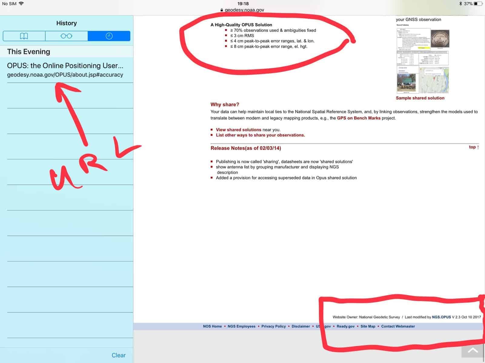
I cannot seem to edit my post. Reviewing the images I see they are illegible for my purpose. To view the page from which they were taken go to: geodesy.noaa.gov/OPUS/about.jsp#accuracy
On this page mention is made that a high-quality OPUS solution would have a less than 8cm peak-to-peak error range. The page was last modified on 10 Oct 2017.
HTH,
DMM
For the last OPUS derived solution on my office point, I submitted it and OPUS chose 3 far flung stations for their processing. It varied from the one I did in Trimble by .12′. The OPUS solution was low .21′ from the actual NAVD88 elevation for the point. The Trimble value, calculated with TBC was .09′ low which isn’t too bad. Resubmitting the exact same file to OPUS but requesting closer CORS resulted in an OPUS solution that was .10′ low, very close to the Trimble number, I never did submit it to RTX.
OPUS is a wonderful resource, but first principles rule, you dance with the one you brought or you get in trouble.
I had read that there is no difference between Geoid 12A and 12B for anywhere I might be working. So not being one to believe anything without proof I did a test for some nearby locations:
PT#1 N45d W107d 12A-45.84′ 12B-45.84′
PT#2 N44.30d W107.15d 12A-27.59′ 12B-27.59′
PT#3 N44.30d W106.30d 12A-46.63′ 12B-46.63′
It appears that any file I have with 12A will be compatible with any file that has 12B as a Geoid Model, just like the article said.
I would suggest anyone who works with GPS do the same type of test.
If you click on a picture it enlarges and is readable.
I see the 8 cm p-p ellip ht number, and I stand by my own criterion that 8 cm is garbage that I would not submit. Around here I nearly always see under 2 cm p-p and if a session is much more than that I don’t trust it.
They must be allowing for areas with poor CORS coverage or poorly maintained CORS? If accuracy is ever to improve to the limits of the propagation effects, the CORS sites must be maintained better than some of the examples we’ve seen with a few cm variation from their record positions.
———
Moe said: I had read that there is no difference between Geoid 12A and 12B for anywhere I might be working.
NGS has that statement on their web site, so it’s not just someone’s impression.
.
If the GPS derived elevation AND the leveled elevation agree, count yourself lucky, even with no errors in leveling or GNSS errors they rarely match exactly, simply for the fact that the geoid model is just that a MODEL!! Unless the BM you are using is a GPS on BM mark and was held during the creation of the last geoid model, there will be almost always be some discrepancy. For FEMA work, it is generally relative to the FIRM reference marks and that is what I would do ONCE verifying the reference marks are reliable, if they have been disturbed or you are in an area of uplift or subsidence, then all bets are off on using the reference BM’s and professional judgement would probably dictate using active control and you should be within +/- 0.1 feet of datum. SHG
- Posted by: Shelby H. Griggs PLS
If the GPS derived elevation AND the leveled elevation agree, count yourself lucky, even with no errors in leveling or GNSS errors they rarely match exactly, simply for the fact that the geoid model is just that a MODEL!! Unless the BM you are using is a GPS on BM mark and was held during the creation of the last geoid model, there will be almost always be some discrepancy. For FEMA work, it is generally relative to the FIRM reference marks and that is what I would do ONCE verifying the reference marks are reliable, if they have been disturbed or you are in an area of uplift or subsidence, then all bets are off on using the reference BM’s and professional judgement would probably dictate using active control and you should be within +/- 0.1 feet of datum. SHG
There’s been a lot of discussion about this, if there is uplift or subsidence across an area then the BFE should change in a global sense. However if the bench marks in the area lift or subside with the ground they still would be the control of record for given BFE’s. I don’t know what goes on near the coasts where there is lots of movement, are there some kind of adjustments made by FEMA, here the BFE’s will be fixed for decades.
- Posted by: MightyMoe
There’s been a lot of discussion about this, if there is uplift or subsidence across an area then the BFE should change in a global sense. However if the bench marks in the area lift or subside with the ground they still would be the control of record for given BFE’s. I don’t know what goes on near the coasts where there is lots of movement, are there some kind of adjustments made by FEMA, here the BFE’s will be fixed for decades.
Unsure, obviously water flows to lowest point no matter what we call it or reference it too. I recall the case in TX where a surveyor surveyed to a BM for an elevation certificate, problem is the BM and the structure had both sunk and of course flooded. If the surveyor had of at least checked with OPUS, etc. they would of discovered something was up, so I would verify any BM with GNSS, if it is close, hold the BM and roll on, if it looks like bad BM, then you have to start earning the professional title! With large subsidence I would hope FEMA would update the BFE on the FIRMS, but I don’t know if they do or not, they seem pretty static (stale).
I agree for sure, I think the best thing about GPS and BM’s is that you can pick out a bad BM so quickly. FIRMS are more than just engineering, they have to go through a community acceptance process. They then become political. It’s difficult to change them because of that. And to reengineer them would require new data collection, someone has to pay for it, I should think that would be covered by insurance premiums, but I don’t really know how that works, it seems to proceed at glacial speeds.

Log in to reply.