
Activity Feed › Discussion Forums › GNSS & Geodesy › Listening to surveyors argue

@mark-mayer NAD83 closely approximates astronomic. For most applications the difference is trivial.
 Posted by: @thebionicman
NAD83 closely approximates astronomic. For most applications the difference is trivial.
… so long as your astronomic observations take into account the Laplace correction due to your local deflection of the vertical, which may typically be several arc seconds and in some places much more.
. Posted by: @mark-mayer
Basis of Bearings is an argument that get me going. I could not care less what your basis of bearings is. I have never, not once, had different bases of bearing affect the ultimate placement of my monuments one way or the other. Bearings are just a convention for annotating angles.
Now, basis of coordinates (ie/ projection and datum) is another matter.
Wholeheartedly agree. For some reason mentioning the c-word (coordinates) in relation to boundary, monumentation and records of survey tends to be a problem for surveyors. Basis of Bearing is much more soothing…even though it is derived from…coordinates.
If your geodetic basis of coordinates is reproducible in any way, shape or form, a BoB statement is unnecessary.
“…people will come to love their oppression, to adore the technologies that undo their capacities to think.” -Neil Postman@rover83 Except where the explicit language of the statute requires it…

More information is always better than less.
On bearings, on coordinates, on metadata.
N

There is the rub. A B.O.B. statement has to go on every survey because of a statutory requirement. Not because it is useful, not because it makes sense. But simply and solely to satisfy a statutory requirement.
For a long time around here the county surveyors (there are 3 counties in the Portland Metro area) would accept only a record bearing between 2 original plat monuments as an acceptable basis of bearings. Or an astronomic observation. They would not accept GPS observations as a basis unless you showed a pair of geodetic monuments of record. What a pain. Thankfully, the guys in those positions today have a little more sense.
@norman-oklahoma We intend to fix our statute to allow system statements in addition to the ‘pick a line’ method.
“Bearings by GPS” will still get you whacked…
 Posted by: @i-ben-havin
Used this accurate time, together with angle ties to top/bottom of the sun, and an ephemeris. Also did Polaris observations at night time. Polaris observations seemed to yield the best bearings.
A Roelof’s solar prism tightens things up a bit although they originally cost about $600. It also eliminates semidiameter corrections. Agreed Polaris observations are more accurate because its apparent motion is much less (apparently nil at elongation so time is not needed), sighting a point instead of the edges of raging nuclear ball of fire, and less atmospheric turbulence at night.
Lest someone chime in that Polaris can be observed during the day, yes, but it’s really hard, nearly impossible unless you have the azimuth of your backsight accurate to less than a minute and an instrument with excellent optics (T2).
That’s a good fix. I don’t really care for the “we don’t understand this stuff so we’re just gonna lump every requirement together and force the professional to make a statement that really doesn’t make sense in context.”
And I agree, “bearings by GPS” ought to be a no-no. Have run across a few ROS and plats with that note. Always a sinking feeling when reviewing those…
“…people will come to love their oppression, to adore the technologies that undo their capacities to think.” -Neil PostmanHere is an example B.O.B. statement I made on the last map I recorded in Multnomah County.
Oregon law calls for the surveyor to give a B.O.B. It doesn’t say what a satisfactory B.O.B. is. According to state law “assumed” would be sufficient. But the County Surveyors have the power to make up their own rules.

1-900-410-time. I used that a lot to set my HP41 clock. Little did know how ??late?? that signal was.
So now I use the event logging in my Z12. I get very good azimuths by sun. And Polaris at 40?ø is not much better.

I find the equal altitude solar determination interesting, and it seems an instrument could be made similar to the solar compass for making a determination. Maybe call it an equal altitude solar compass. I find that if I take the occular lens off my old topcon, and turn the objective lens away from the sun, with the zoom lens facing the sun, that a very compact image of the sun (about 0.01′ in dia.) can be focused at about 1 meter in focal length, and then can be projected (in this case) to a table which I made to rest atop the lower tripod legs. My thought is to then direct the image by way of the vertical and horizontal motions onto the plumb point beneath the instrument at mid morning and zero the horizontal reading, then without then moving the vertical (altitude)
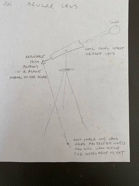
component, wait for the mid afternoon to align the image, with the horizontal motion, back unto the plumb point.

Well, my two cents worth is here:
First, when I started surveying back in 1980 at a company with surveying crews, we used a transit, 100′ steel tape, plumbobs, and a magnetic compass declinated to true north as set from and frequently checked using a nearby triangulation station’s azimuth mark. Once, we immediately went back to the office and set up a point and measured a direction to a couple of nearby visible objects for quick checks.
Later, in the mid to late 80’s, we did direction determination by solar observation using the altitude method. I never learned that particular method, but did learn and extensively use the solar observation hour angle method. Elgin and Knowles handbook had the ephemeris tables, and later, in the early 90’s, was a website that had an ephemeris that could be printed. I had an HP41CV calculator program that would calculate an azimuth when accurate time, lat/long, and stopwatch lapse times were entered. Later, the HP48 with a TDS survey card was used, but we had to convert UT1 stopwatch start time plus stopwatch reading to an actual time for each time entry. That took two calculators.
All that changed around 2012 when I switched systems and started using GPS and State Plane Coordinates. After studying what I had and could do with GPS, I compared that to what I determined I needed for boundary surveying.
Back in the old days, I figure one could get a direction accurate to probably the nearest quarter of a degree, or 15 minutes, using a properly adjusted and declinated surveyor’s magnetic compass. Years of knowledge gained by a fellow surveyor comparing directions made from solar observations with the old USPLSS field notes bearings, he found there was an average of about 23 minutes difference between the two. He used it as a check when retracing section lines.
In my opinion, when retracing old surveys, a reference to true north was determined and used by the original surveyor. In order to retrace that line on the ground, find the evidence, and other evidence relied upon for adjacent surveys done in the past, one needs to utilize as best can be determined, the same “north” previously used, which to me, is North as referenced to a true meridian.
I am blessed to work in a county in my state where the central meridian of our state plane coordinate system passes through the middle of our county. My convergence angle corrections from grid to geodetic north range from negative to positive 6 minutes or so, which is pretty close to true north. But to best retrace old boundary lines and make my piece of the “jigsaw puzzle” better fit field conditions, I rotate my grid bearings to geodetic bearings and use ground distances. That way, I can find stuff and leave my footprints for others to follow.
There is much to be said about converting all new surveys to all grid – both direction and distance. Around here, there’s not that much difference between grid and ground, especially when surveying “John’s Little Acre.” Down the road, that seems to be a good course of action to take, especially when land parcels are being plotted on a county tax map system or other GIS portals, and the land parcels need to mesh together with a common theme in mind.
Times have changed, and they keep changing.
There. That’s my two cents.

I have done hundreds of astro azimuth observations, mostly many years ago, in the 80’s and early 90’s.
First one was when I was an instrument man on a USCE crew, and I had been reading Davis, Foote, etc cover to cover. We were doing a sedimentation survey where you recover pairs of mons (with SPC) on opposite sides of a lake, and run a profile between them. Typically there were two mons on each side, one above the spillway elevation and one closer to the water. This particular lake was on the OH-PA border, and the terrain was pretty flat. We found one monument in high brush in summer, could not see anything to orient. I told the party chief we should do a solar. He scoffed and walked off into the brush to try to find the next mon on the line. I did a solar with my HP41 for time, ran it through the program I had loaded (Elgin & Knowles), and we hit the next mon right on, and I was convinced.
Over the years I have done many second order polaris azimuths with a T3 (16 sets), lots with a T2, and have used other stars, Jupiter, and even the moon. In the early days of GPS it was too expensive to use GPS to set azimuth marks, so we did a lot of polaris when azimuth marks were required.
Coincidentally, I attended a Mason Dixon history/Polaris observations workshop last Friday near Morgantown, WV (Mason Dixon Historical Park). The method they demonstrated was Polaris by the altitude method and using tables, there were no trig functions. Very interesting, I had never computed one that way, but right away I noticed that they were using a sea level pressure in the refraction formula (from weather reports), and they didn’t know there was a difference between that and station pressure. Not sure how much difference that would make. There was some discussion about accuracy, they were saying that they agreed with GPS at about 7″. I know that Polaris can get better than that with the right equipment, I would say 1″ to 2″. Solars about 5″, same for the moon (polynomials required for the moon). They also were not aware of the potentially large error caused by mislevelment. Now that modern instruments have dual axis compensators, the problem is greatly reduced, but one should be aware if using a T2, etc.
They also told a story that someone else had assigned an azimuth to a pair of monuments at the park using GPS, and they found it to be 46′ off. Turns out the convergence there is 23′, they went the wrong way after doing a grid inverse and applying the convergence to get geodetic azimuth.

So what is the benefit of knowing the odds of being pissed on? Worthless because there are too many variables at any given time. End one in use, out of order etc. Also there was no consideration given for inebriated leakers whom are known for their off track trajectories, misfires and the ability to pee at a 90 degree angle in the normal stance. Now that bathrooms are a free for all for all five of the current gender identities your built in emergency shut off valve goes haywire trying to figger out who??s what, that you can??t pee anyway. ????
- Posted by: @john-hamilton
Polaris by the altitude method
My intuition says that might be good when Polaris is near elongation, but far worse than using wristwatch time when it is high or low and traveling nearly horizontally in your view. Add refraction to that and it might not even have a solution.
. 
@flga-2-2
It’s true! Not all actuaries are straight-shooters!
@bill93 I didn’t really understand why they were computing it that way, you need to have the tables (the ones they had were from the UK), and the refraction correction is a potential problem. The issue with the sea level pressure versus station pressure made me think they don’t understand a lot of this. They probably use the SLP to correct EDM observations as well.
They did have time recorded to the nearest second. Seemed like they were trying to avoid trig functions.
I believe the altitude method was appropriate when you didn’t know the lat/long of the observation station, and/or when you didn’t have accurate time. A smartphone would take care of each of those issues. BTW, when using a cell phone you should get an app to get accurate time, the displayed time is sometimes offset from UTC by fractions of a second or even several seconds. I think we had a discussion of this issue years ago.
And they really had no understanding of the Laplace correction.
But, I enjoyed the seminar because it presented a method I was not familiar with, and also the Mason Dixon history part was interesting as well.


Log in to reply.