
Activity Feed › Discussion Forums › Business, Finance & Legal › Landlocked parcel
-

John,
How does the next section of the subdivision, going up Cork Road, show the remainder lands?
Just surprised that at the time the subdivision was done a cul-de-sac into the remainder parcel wasn’t part of the design. The municipalities in this area would have required a dedicated roadway up to the remainder parcel to provide access and possible future development, even in the 60’s.
PLS NJ & NY, PP NJ -

Total mystery to me why they did not develop this. My best guess is that they were hoping to acquire my parcel and come in from that way. As you can see from the GIS image in my post above there is no access on any side except mine from the north, other than maybe demolishing a house.
I bought my 8.5 acres at an auction in 2001 after the owner passed away and they wanted to settle her estate. There was a 5 bedroom mid 1950’s home at the road to the west that I had to demolish to be able to get a sewer tap for my new house at the NE corner of the property. At the time there was a moratorium on new sewer taps, which has since been lifted. I just recently bought #571 on the road which was originally part of my parcel until they cut it out in the 50’s. A house was built there, it burned down, then in the 60’s or 70’s the current house (4 bedroom) was built. I am selling that to my daughter once the rates come down, currently having remodeling done on it.
-

My guess is they will take the bearings and distances from the subdivision plan with some POB, probably my SE corner. Which is probably the best way to do it without a survey that located the existing lot corners.
Don’t be surprised if your description just says “667-K-106”
-
I would not be surprised. I can’t imagine that the sheriff’s office has an attorney or surveyor prepare it. The very simple document that I have to take down there tomorrow with my info for the deed says “you can call in 8 to 10 weeks to check the status of your deed”
-

99.99% sure this (tax parcel number only) is what it is going to say. The vast majority of the sheriff’s sale deeds around here (eastern PA) are written like this. If you are very fortunate it will have some kind of chain of title recital at the end, but most don’t include that either.
-
This reply was modified 3 months, 3 weeks ago by Alan Chyko. Reason: Thought the post I was replying to would be quoted
-
This reply was modified 3 months, 3 weeks ago by
-

I don’t think anyone has mentioned this. Check out your redemption statutes. I wouldn’t proceed with anything till the statutory time has passed if there is one in your state. I assume there is.
-

In todays world parcels like K-106 would be designated open space tracts and held by the public (usually via the relevant parks department) in perpetuity as mini wildlife refuges. Modern subdivisions in Oregon have these sorts of things created on purpose, as a condition of approval. Missing here is an access easement.
-
This reply was modified 3 months, 3 weeks ago by Norman_Oklahoma.
-
This reply was modified 3 months, 3 weeks ago by
-

In todays world parcels like K-106 would be designated open space tracts and held by the public (usually via the relevant parks department) in perpetuity as mini wildlife refuges. Modern subdivisions in Oregon have these sorts of things created on purpose, as a condition of approval. Missing here is an access easement. – Norman
And P&R enters the discussion as we open the door to the planners taking vast tracts of land from a developer. But one might wonder if that was the intention and why property taxes didn’t get paid on it.
-All thoughts my own, except my typos and when I am wrong. -
These things were likely not considerations in a 1950’s subdivision, but may be when John goes to subdivide his holdings in the present.
I’m of two minds where it comes to the fairness of these policies. On the one hand it does cut into the developer’s profitability. On the other it does enhance the liveability of the developments, and thus drive up the prices of the lots that are developed. Little patches like this provide places for bugs to hatch which feed the birds and small critters, which in turn feed the larger beasties. So they are quite beneficial. Whether developers should be obliged to make the sacrifice or the public should be paying for these things directly is debatable. My recent experience in city government has alerted me to the fact that developers get a lot of credits from a lot of funding sources for these things – it’s not all on their backs.
-
This reply was modified 3 months, 3 weeks ago by Norman_Oklahoma.
-
This reply was modified 3 months, 3 weeks ago by
-
I don’t think anyone has mentioned this. Check out your redemption statutes. I wouldn’t proceed with anything till the statutory time has passed if there is one in your state. I assume there is. -MM
This page has some info on that, it is interesting to see the wide range of laws that cover the United States and how much they differ state to state. I am no expert, but the matrix on the linked website is very general. I know that in WA, for instance, there are redemption laws on the books, but the site shows it as not available, so I imagine it is more complex than a simple yes or no in some states.
https://www.nolo.com/legal-encyclopedia/50-state-chart-key-aspects-state-foreclosure-law.html
-All thoughts my own, except my typos and when I am wrong.
nolo.com
Key Aspects of State Foreclosure Law: 50-State Chart
Check out this 50-state chart to learn about the important features of each state's foreclosure procedures.
-
I have a couple of buddies from HS and they will buy up Sherriff sales and then hope they get redeemed cause they have to be paid interest on the sale price. Better than a bank they say. If they aren’t redeemed then they have a plot of land. Usually they get redeemed.
-
Kind of a win win for everyone except the bank?
500k loan, property worth 600k if not in foreclosure, foreclosure sale of 200k, buy back from bidder for 250k? Something like that?
-All thoughts my own, except my typos and when I am wrong. -
Whether developers should be obliged to make the sacrifice…lot of credits from a lot of funding sources for these things – it’s not all on their backs. – Norman
From my perspective, the big companies deal with this, and in the end it simply increases their profitability. Drives out the small guys, so a win win win for the big developers. Basically, it works like any regulation.
My problem is not really about the political ideals of obligations and the protection of property rights (which it could be if we were on Twitter), but more about the impact it has on the cost of housing. The process you described creates a situation where the public is paying to have fewer houses, and therefore to pay to price themselves out of housing. It is a process that is not transparent to the average college student graduating from a state school, they just get sold on helping the bugs you talked about.
The city/county bureaucracy has a vested interest in fewer houses and people (less demand for services) living on more expensive real estate (greater revenue from property taxes). I do not mean to say that individuals have that motivation, but a bureaucracy has a kind of sentience all its own. As we often hear, the road to hell is paved with good intentions, and our road to insane housing costs is paved with those good intentions as well.
We, as surveyors, generally appreciate the wild world, and we also generally care very much about property rights due to the nature of our work, so the environmental impacts vs development puts all of us in a bit of two minds, I would think. Be that as it may, people get the city they vote for. I think it would go a long way if we had some transparency to the process, and people understood the results of the policies.
People of all political and cultural and economic backgrounds are always shocked when they learn the amount of friction there is when attempting to develop their land…unless they are a big developer.
-All thoughts my own, except my typos and when I am wrong.-
This reply was modified 3 months, 3 weeks ago by dmyhill.
-
This reply was modified 3 months, 3 weeks ago by
-

Fortunately, the following photo made its inaugural appearance on Facebook on Monday courtesy of a organization promoting the specific city. The story relates how the two dog parks were so popular with pet owners that THE POWERS THAT BE had decided to make the additions shown in green.

-
More like $2k for the property covering back taxes and get $2.2k back in a few months.
-
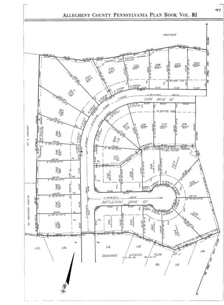
I finally got the deed from the sheriffs office. Very strange. They simply say it is lot 204 in Dashwood Estates Plan of Lots #2. However, there is no Lot 204, and that is a different section of the parent tract. They did get the previous deed correct. It is shown better on Dashwood Estates Plan of Lots #1, but still not shown as Lot 204.
shown below is the page from the plan (Plan of Lots #2) they reference in the new deed. and below that is Plan of Lots #1. In the first it is the tract which is just barely shown in the lower left (N/F Crestview Land Co), and in the second it is on the right (Crestview Land Company). On the new deed it is Crestland not Crestview.
So to me they just made this up. I realize it is state and county specific, but what I am hoping to do is file a corrective deed with a full description. Does that make sense? I am not even sure of the procedure for that in my county.
-
This reply was modified 1 month, 2 weeks ago by john-hamilton.
-
This reply was modified 1 month, 2 weeks ago by john-hamilton.
-
This reply was modified 1 month, 2 weeks ago by
-

It looks like you have access via 50′ Cork Drive on the south: It stubs right into the parcel you reference.
-
Seems like people post without reading the original post or prior posts. Sort of like the old “telephone” game.
It is adjacent to my property, I have 500+ foot of common boundary, so to me there is access. I was not looking for access, just wondering what the deed would be that they come up with, and it was basically “made-up” by someone in the sheriffs office, because they invented a lot number and referenced the wrong subdivision plat. I will just use the metes that are on the subdivision plat and then my common line, which will then be the whole way around the tract.
SO, in the image below, the red line is the dividing line between the Dashwood 1 and Dashwood 2 subdivisions. The green line is the common line between my current property (667-K-50) and the property I bought at sheriff’s sale (667-K-106). The west line of the purchased tract (from the west end of the red line up to the green line) is from a different subdivision.
So they called it lot 204 in Dashwood 2. But, there is already a Lot 204 in that plan.


Log in to reply.