
Activity Feed › Discussion Forums › Software, CAD & Mapping › Is there a Civ 3D tool that correct occupation errors?
Is there a Civ 3D tool that correct occupation errors?
bushaxe replied 2 years, 6 months ago 16 Members · 32 Replies

Thanks for all of your responses. It looks like Topcon does have a solution. Their desktop software “Topcon Link” sorts data by station and allows any point stored as a control to be swapped in. I guess I don’t need civ3d.
- Posted by: @leegreen
@bushaxe From this statement I would think @cworld29 is a student. Your comments have merrit for an experinced crew, but this student seems to be learning the hard way.
Yes I am. It helps to try and fix a problem before the instructor explains; just easier for me to understand that way.

@norman-oklahoma
Posted by: @norman-oklahomanor even really reviewing, their data.
I think we all might be surprised at this.
I’ve talked to some field guys who were used to just exporting the coordinates, and they say stuff like they do their inverses right there in the field and they check “balls on”.
I mention that if somehow they put in a bad BS point number, they could be staking everything out wrong, but their inverses on their DC and in CADD would tell them they did it all right. I’d get a blank look, and they’d just repeat about their inverses.
 Posted by: @jph
I think we all might be surprised at this.
I’ve talked to some field guys who were used to just exporting the coordinates, and they say stuff like they do their inverses right there in the field and they check “balls on”.
I mention that if somehow they put in a bad BS point number, they could be staking everything out wrong, but their inverses on their DC and in CADD would tell them they did it all right. I’d get a blank look, and they’d just repeat about their inverses.
It’s not just field staff. It’s usually the office folks who tell them to just do coordinate dumps.
I worked for a firm with a satellite office that never QC’d their raw data. Their crews never took notes either. When I mentioned to one of the six licensees that there was no way to check rod heights, offset directions, measure-ups, feature codes, or even what type of gear the crew was using, I was told “We pay our crews to not make mistakes.” They had the most f’ed up datasets out of the entire geomatics group, and were always wondering why none of the other offices wanted to workshare with them.
Posted by: @leegreenAppears the younger generation only work with cartesian coordinates. They don’t seem to maintain the raw data anymore, or just don’t know-how. A sad fact.
Who do you think the younger generation learned from if not the older generation?
All those licensees in that satellite office were older than me by anywhere from 10-20 years. I’m 38.
“…people will come to love their oppression, to adore the technologies that undo their capacities to think.” -Neil Postman Posted by: @rover83
I worked for a firm with a satellite office that never QC’d their raw data. Their crews never took notes either. When I mentioned to one of the six licensees that there was no way to check rod heights, offset directions, measure-ups, feature codes, or even what type of gear the crew was using, I was told “We pay our crews to not make mistakes.” They had the most f’ed up datasets out of the entire geomatics group, and were always wondering why none of the other offices wanted to workshare with them.
I was having a conversation once with a PC about some questionable data. He got rather flustered and stated “I stand behind my data”. To which I replied. “No, I stand behind your data !”
BTW, “QC” is in how the data is collected. Checking it in the office is “QA”.

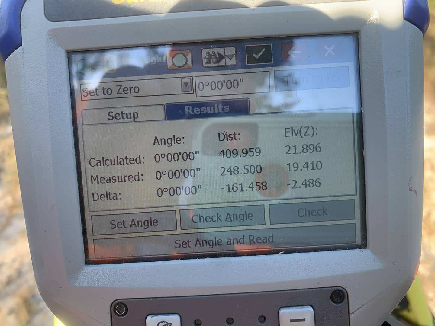
Jere is an example of how a BS Check saved me today. I thought for sure the BS pt# was 1204 Turns out it was pt# 1203. I even checked my notes and read it wrong. But my measurement didn??t lie. Just a little off.
 Posted by: @leegreen
Appears the younger generation only work with cartesian coordinates. They don’t seem to maintain the raw data anymore, or just don’t know-how. A sad fact.
Lee
I know just as may older surveyors who just download coordinates and not the raw data. When I ask them why, I am usually met with a blank stare.
PLS NJ & NY, PP NJ
Not just “older” surveyors either…we have folks here that do a straight point dump from the collector and straight into CAD.
Personally, I’ve seen too many issues along the way, (plus I have a support background so I’ve “fixed” lots of folks data) so I put everything through TBC before going to CAD. I’m trying to get others to do the same, and most do, but there are still a few that don’t use TBC “unless there’s a problem”, which in my opinion may be too late.
Once, a group staked a mile of pipeline with an autonomous position as their starting point and couldn’t figure out why it was “off”.
T. Nelson – SAM, LLC
And it’s the same thing with GPS. Normally there is an error trapping routine for bad set-ups but it doesn’t catch “close” points. It’s possible to have two close points and put the incorrect number down for the base point. It’s very helpful to have a check-in point before you start surveying.
Absolutely, its the same thing really.

Log in to reply.