
Activity Feed › Discussion Forums › Strictly Surveying › How to Inverse Between Points with SPCs
How to Inverse Between Points with SPCs
bill93 replied 10 months, 4 weeks ago 10 Members · 25 Replies

ok so grid state plane coords are just plane coordinates simple math.
Thanks for clarifying that. If I understand you correctly, I would use a convergence angle to orientate my section lines to true (astronomical) north. I’ve attached a plat of a project I’m working on so you can see how the center of section line relates to the plat. I assume the north arrow is pointing to grid north.
MH
Adjusting the grid azimuth by the convergence angle produces the Geodetic Azimuth. Adjusting the Geodetic Azimuth by the LaPlace Correction produces the Astronomical Azimuth. For point AK7150, which is within a mile of 48451, the LaPlace Correction is -1.70 seconds, likely insignificant, but necessary to keep the nomenclature consistent.
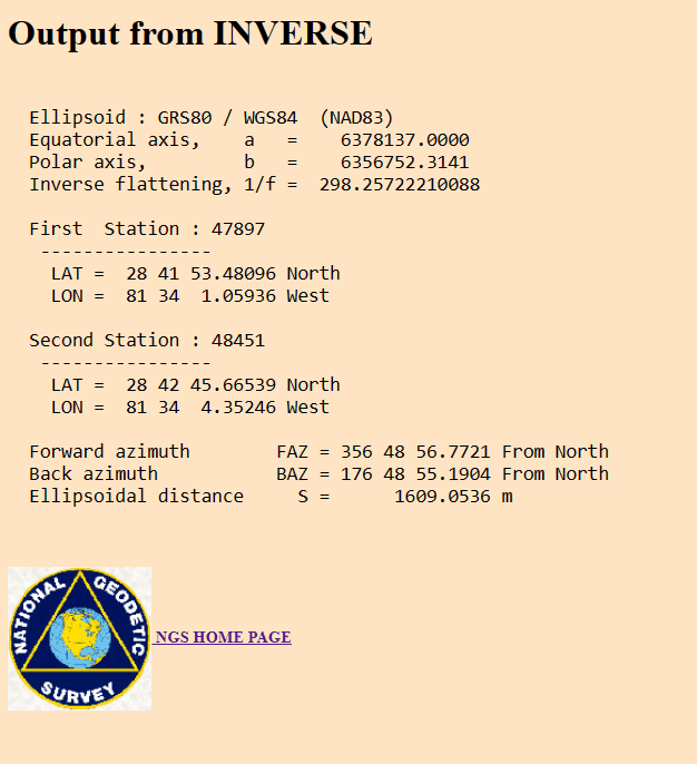
The picture below is from NGS INVERSE, calculating the ellipsoid distance and geodetic azimuth between 47897 and 48451. Note that the ellipsoid distance converts to 5279.037 feet, a thousandth of a foot different from the State Plane calculation, and the geodetic azimuth is about 1/4 of a second different from the geodetic azimuth calculated from State Plane.

@field-dog you would use the convergence angle to go from grid bearing to geodetic bearing based on that datum. Then use the laplace correction to get to true or astronomic north. Slightly different depending. If my memory serves me in the plss makes sure of the direction they ran in to compute as true north is not a simple 180 degrees difference forward and backwards. Thats probably in the weeds but if you want to learn then learn it correctly. As then you don’t have to assume when something is close enough. So let’s look at this. A plat has a magnetic bearing from say 1960. Pre nad 83. Can we use that magnetic azimuth or bearing to get to grid bearing. In theory we can. We can look at the magnetic declination for that time and convert to true aka astronomical north then we can apply the laplace to get to geodetic then project it to the grid so in theory we can go from one to another. Now in reality we don’t go through all of that always. We simply look at monuments held hold a line and we use say interior angles from bearings etc. if you look at old maps not plats they have a declination for that date between grid and true and magnetic. We can even look at the magnetic azimuth from say 1960 and see the difference of today’s magnetic and apply the difference. But we also need to realize how they might have done or performed a magnetic bearing and its accuracy. A compass so not to the second. It is why angles and distances fall down on the list of priority of calls. We use the bearing and distance to check. But the natural monument holds above the rebar pipe and is hen measurements. And measurements hold above the area etc. one thing that’s awesome about surveying is you cannot ever stop learning. Always something to learn.

north is not a simple 180 degrees difference forward and backwards.
Geodetic north and south are exactly 180 from each other. If there is an east-west component to the line then forward and reverse will be slightly different from 180 apart. Probably negligible on lot surveys but quite significant for a long E-W corridor.
.

Log in to reply.