
Activity Feed › Discussion Forums › Strictly Surveying › Deed Versus Long Term Occupation

@bill93 details schmeetails

I’m sure there are cases like two “60 ft” lots measure a total of 119.5 ft. Does the first lot resurveyed get the full deed distance?
.
@bill93 In a simultaneously conveyed plat, no. The idea is to “stake the deed” but there is technical interpretation including proportioning.
My point is you are always issuing an opinion.
proportioning is applying case law.
The only cases I have found in California that mention proportioning mention it as an aside, the cases were resolved other ways. The judge is saying proportioning is a thing but we have a superior method here.
 Posted by: @half-bubble
presumably because the deed corners were behind the fence that the HOA was asking to have moved.
Strange. We would be required to search for or set property corners on any survey. ( or witness corners )
Posted by: @half-bubbledid not enforce anything regarding the chain link fence between the two private lots.
So are these platted lots? Why are we not referring to these as lot corners rather than deed corners? Assume in 1990 these were private lots based on the post. For how long had the fence been there and how long have have the lots been in private ownership? I would have investigate these things as part of a survey. For what purpose was the fence constructed and did each owner treat it as the property line before 1990? How about after 1990? The answers will allow one to form an opinion as to what laws or rules to apply to the facts. If the fence was placed as a partition between properties near the time of first conveyance it could indicate best intent of the conveyance absent any testimony by the first owners. This is not acquiescence or adverse possession. It’s retracing the first established property boundary. If the fence came later on after the original owners unwritten rights may apply. If a surveyor believes they aren’t allowed to determine unwritten rights fine. But if you truly believe there may be unwritten rights involved and you aren’t allowed to survey a property line opinion it is unethical at least and illegal at most to finish the survey until it’s settled. The duty of the surveyor is to mark one property line. If you can’t for one reason or another don’t.
Posted by: @half-bubbleThey set the front corners
Have the set corners ever been accepted by the actions or inactions of the land owners since they were set? Was the 1990 survey a retracement or an independent resurvey? (deed stake)
I don’t want my comments to call out anyone in particular. But in general surveyors really need to think about their commission. Are you licensed to be a technician following a set of rules for every survey or are you licensed to be the first legal option for owners in defense of their property line by forming a solid opinion based on facts and law? I assume all surveyors have a certification such as ours where they certify that the survey was done under their direct personal supervision under the laws of the state. If surveyors aren’t allowed to form a legal opinion of the property line why do we certify to it?

I find the terminology of “deed line” to be counterproductive to the process of boundary retracement. A deed or legal description points you to the real property and gives you insight as to the basic intent of the grantor but it has long been understood that written descriptions are imperfect. I use the term “deed math” as in, “use the deed math to help you find the boundary, then measure the boundary”. I remind myself and my staff that every boundary has already been established before we arrive. Also, a judge does not need our measurements to solve a boundary dispute. Judges don’t seem nearly as concerned as some surveyors with the, “How close is close enough to hold this iron?”, question. Hold it or don’t based on best available evidence with the recognition that the deed math is a pointer and not better available evidence than what is on the ground.
There was a post a little while ago from a lady in England looking for advise. I found it fascinating that in parts, or maybe all, of England they don’t include courses and distances in their deed descriptions. How would one survey a “deed line” when given only a bounds description? If you were able to do it, would you then move onto the next survey and show your math line cutting through a 150 year old granite foundation for a root cellar? Would you run a math/deed line through a cobble driveway and consider it a job well done? What’s the point of a deed line or math line if not just to CYA by eliminating the most difficult aspect of surveying, i.e. making a well reasoned and researched decision?
The rules and principles that we follow are defined by case law.
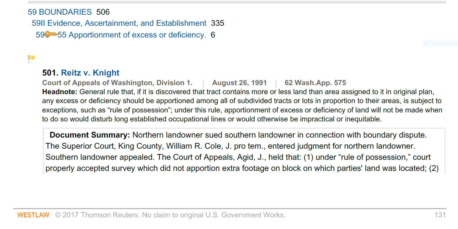
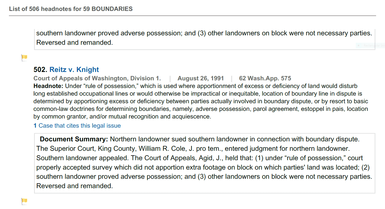
The Washington Court says that the general rule is that excess or deficiency shall be apportioned proportionately among the several lots EXCEPT in the case where it would be contrary to longstanding possession or otherwise be impractical or inequitable. It is improper to apply the rule without considering whether an exception applies.
In one case proportioning would place the lot line under an existing house which had been there for decades, the Court ruled proportioning should not be used in that case since it contrary to the rule of possession.
I haven??t looked to see what pronouncements the Washington Courts have made about fences. Fact items such as fences are harder to look up because the legal rules are indexed but not things which are more fact oriented such as physical objects. Generally Courts say that fences are more equivocal than buildings and walls so may be harder to prove as a boundary than something more permanent such as a building.
We have an unpublished case in California that is similar to the O.P. scenario. It was in an old subdivision with a fence. The boundary was staked by a surveyor from remote non original control. The Court ruled in favor of the fence not because it was evidence of the original lot line but because one neighbor discussed modifying the fence at her own expense with the other neighbor and they agreed so the Court ruled that was sufficient to prove mutual uncertainty and mutual agreement that the fence is the boundary.
- Posted by: @dave-karoly
The Washington Court says that the general rule is that excess or deficiency shall be apportioned proportionately among the several lots EXCEPT in the case where it would be contrary to longstanding possession or otherwise be impractical or inequitable
Seems like a wordy way of saying last resort.
@norm right, it??s an equitable rule so it shouldn??t be used to produce an inequitable result.

@half-bubble I (not knowing much) agree. A record (or not) map showing a potential encroachment by a PLS only adds evidence to the notorious-ness of the occupation, grounds for adverse possession. But until it’s ripened and decided by court it’s still owned by the deed holder (maybe unless it’s part of a necessary access route to the adjoiner or other possibilities) and can be treated as such. But that would all be free opinion. Cheapest route for the encumbered owner would at this point be (ie if I were the landowner) to simply write a letter to the adjoiner stating that it’s cool for the foreseeable future that your fence veers onto my property a little bit. Without an immediate legal response, that would eliminate the notoriety and stop the clock. That might be legal advice though, so… idk what kind of trouble that could bring.
dd- Posted by: @dave-o
Without an immediate legal response, that would eliminate the notoriety and stop the clock.
Apparently not in Washington State. The “true owner” (owns the deed) giving “permission” to the occupier does not stop the clock here. Only a removal of the occupation stops the clock.
- Posted by: @half-bubblePosted by: @dave-o
Without an immediate legal response, that would eliminate the notoriety and stop the clock.
Apparently not in Washington State. The “true owner” (owns the deed) giving “permission” to the occupier does not stop the clock here. Only a removal of the occupation stops the clock.
Weird. I wonder how they walk around an established definition of adverse possession. Maybe they call it something else?
dd 
As I read it in the case law, “permission” is not the original owner simply telling the adverse possessor that they’re OK with an encroachment – only a mutual agreement between the owners can constitute permission, and even that can be dicey.
“…people will come to love their oppression, to adore the technologies that undo their capacities to think.” -Neil PostmanYes, to grant permission one or both owners would need to know the location of the property line. The rule of possession the court is referring to applies when the location of the property line is uncertain or in dispute. At least that’s how it is here. From what I’ve observed surveyors tend to use proportion, protraction and deed distances to create disputes and uncertainty. The courts look back to how the owners had settled the property line by their actions even though a survey may show otherwise. We’ve seen countless court cases where a survey placed a “deed line” at a location it never was other than on paper.
 Posted by: @half-bubble
would you happen to have a Washington case law citation for this?
I guess I wasn’t very clear, when I said: I was under the impression, that once a fence is shown on a survey, made known as to the relationship with the deeded boundary, that the clock on the adverse claim stops.
What I should’ve said: Once you’ve been put on notice, permission with conditions has been given, the clock on the adverse claim is stopped.
A good attorney should be able to prove it was implied, when a survey becomes public record.
 I hope everyone has a great day; I know I will!
“When there is a meeting between owners, and the true owner tells the possessor that she can continue using the land with his permission, there is no break in the possessory period. Where the entry is adverse, it is not interrupted by the true owner’s unsought consent. To interrupt adverse possession, there must be actual cessation of the possession.” Lingvall, 97 Wn. App. at 256, in Washington State Common Law Of Surveys And Property Boundaries, Jerry Broadus, 2009, IX-F-5 Hostility and Permission, p. 137.
There may be differences between states.

That’s the way I understand it. Each state is different, but using permission to stop AP won’t work after the fact.

If you are in Montana read this gem. If you are not it is still probably a great gem to read.
 Posted by: @makerofmaps
If you are in Montana read this gem. If you are not it is still probably a great gem to read.
Wow, what a prick showing up to try to steal land 40 years later… Ha


Log in to reply.