
Activity Feed › Discussion Forums › Strictly Surveying › Closed Link Traverse Closure

I was thinking of the conversion from geodetic GNSS bearings to SPC, but if everything is converted to state plane or similar projection before finding bearings, you won’t need to worry about it.
I think there is a small correction if going for extreme accuracy on a long traverse. I forget the details.
.
The crux of the problem seems to be that nobody knows what the coordinates represent — state plane, ground from state plane, something the equipment made up or what?
Point 150, the quarter-corner, is a third-order point that was referenced in the original post but does not appear in the traverse. It is documented to be NAD83 (1990). Now that, according to this, is HARN:
https://www.ngs.noaa.gov/PUBS_LIB/HARN_CORS_COMP/eval_harn_to_cors.html
We can somewhat check this using NCAT to convert HARN to HARN. Note that the coordinates agree rounded to the second decimal and the scale factor agrees:
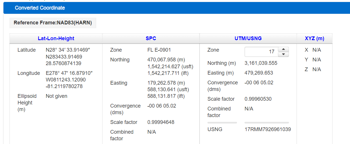
The check is “somewhat” because, if you use the same lat/lon, but convert NAD83 (2011) to NAD3 (2011), you’ll get the same coordinates. That’s because a given lat/lon always generates the same northing/easting on the GRS80 ellipsoid. What we’ve checked is the conversion between lat/lon and state plane on the corner record, not the epoch of the coordinates. It’s a good ponderable for 2022, though.
So, the defined point is NAD83 (HARN), but it was not used in the traverse. It does, however, appear on the list of points given in the original post with the same values as the corner record, but subsequently withdrawn.
Because we don’t know the basis for the coordinates, we also don’t know the basis for the angles, which makes calculating subsequent coordinates from previous stations problematic.
What I expected to see was something more like the traverse described here:
https://archives.profsurv.com/magazine/article.aspx?i=71419
Starting and ending with GPS observations does not preclude ol’ Chuck’s methodology. Not knowing the basis for the coordinates you’re producing is a different story.
 Posted by: @leegreen
Odd that they can find money to purchase equipment but not training.
This makes complete sense.
Government procurement hates spending money on things that are going to happen in the future such as training or preventative maintenance. When there is nothing to show for the exchange except an IOU, it’s almost guaranteed to not get approved.
 Posted by: @kjypls
Government procurement hates spending money on things that are going to happen in the future such as training or preventative maintenance. When there is nothing to show for the exchange except an IOU, it’s almost guaranteed to not get approved.
I’d say replace “government procurement” with “Leadership in the vast majority of modern organizations, public or private”.
And without continued mentorship and learning under the experts within an organization, training in and of itself is pretty much useless. Knowing how to select an option on the DC is different from knowing whether you should or not.
If your organization has no experts, then you’re just going to flail around until you get lucky or screw it up enough to get the boot. The leadership will face no consequences, nor learn from it. Rinse and repeat.
“…people will come to love their oppression, to adore the technologies that undo their capacities to think.” -Neil Postman
From what Lee implies Field Dog works for a municipality. My first advice would be to allow Lee to do some department set-up with your equipment to get it all working together.
There should be no issue with working in a projection, the RTK receivers and the Total Station/Robots can easily be set-up to seamlessly work in the same system. Doesn’t sound like they do.
The combined factor shown on the CCR is 0.999946 which is roughly 50PPM. That is getting to the point where I would simply stay in State Plane. It would be a good choice for such a “small” scale and would simplify work going forward. Everything is state plane, make contractors work with it. GIS and engineers will have no problem. But, you have to get your total stations to be on state plane and stay there. Normally the DC will control all that. If you’re collecting raw distances then each distance needs to be multiplied by 0.999946. Try it and see if you close better. The quick way to do it is inverse between the beginning point and final traverse point coordinates. Get the distance and multiply it by 0.999946 then recalculate using the inversed az and the reduced distance.
Any scale factor beyond six places is 0.1PPM or less, more or less pointless, who needs to measure .001′ in 10,000′?

Log in to reply.