
Activity Feed › Discussion Forums › Strictly Surveying › Center of Section
 Posted by: @dmyhill
Either way, it needs to show up on the survey, and discussed in the narrative.
not to reply to myself, but it seems that if there is an overlap, then there are all sorts of issues. We have a survey we are working on where a surveyor created an issue, and there ended up being a dozen or so homeowners affected. Fortunately, the title company is paying to make it work.
-All thoughts my own, except my typos and when I am wrong.
Moving aliquot lines is has caused unnecessary havoc in numerous sections I have encountered.
1897, Lumber Company Surveyor sets SW1/16th corner post.
1979, Private Surveyor rejects it, throwing roads out of easements, property lines off, the usual chaos.
????????
1888, Lumber Company Surveyor finds Benson Syndicate 1/4S off 900 feet, subdivides section.
1964, Private Surveyor ??hired gun? expert argues in court for single proportioned solution, loses on appeal, second trial second expert says he ??found the original location, a fence crossing the line, convinces 2nd trial judge.
????????-
1890s County Surveyor restores lost section corner by proportioning east-west only.
1967 private surveyor double proportions section corners. By some miracle the property owners with the help of another land surveyor and the current county surveyor ignore the new DP??d corners.
??????????-
Sometimes the technically wrong answer is the right answer.
 Posted by: @mightymoe
There were a number of methods, the 1/8th corners were set when the surveyor surveyed 1/16th corners along the north and south section lines and also ran the E-W centerline of the section setting 1/8 and the C1/4. They did not run the center of the 1/4 sections so they broke the section in 8 parts the E2 and W2 of each 1/4.
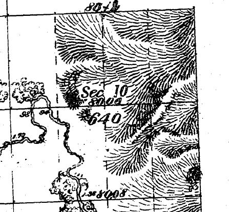
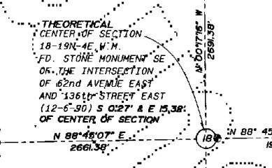
In this snip of a plat you can see the chains labeled along the E-W centerline. to resurvey a lost C1/4 it should be retraced from the E1/4 to the W1/4. The N1/4 and S1/4 don’t apply at all. And you may notice that the E-W CL distance is not a mean of the N and S section lines.
As always we tend to assume what was done by looking at the plat. That assumption always needs needs to be verified by the notes. If they set the 1/16’s on the e-w centerline the C1/4 would be at the midpoint between the 1/16’s (or proportional distance between any other controlling intermediary corner).

Awesome!! Thanks for the share too, that was legitimately interesting and helps with the bigger picture.

Why do I have all the luck?
This is from the second of my last 2 surveys:
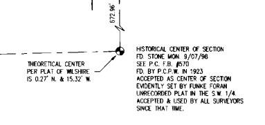
So what is it? 15.32′ or 15.38′?
I hope everyone has a great day; I know I will!
15.32 or15.38 doesn’t matter. He has his theories wrong. In theory, the historical stone used by all surveyors since that time is the center of section. The theoretical center is the stone.

There is only one Center Corner. It’s the one with the established monument used by surveyors prior to your arrival. The mathemagical center is based on four other monuments that exist today but none of which may have existed at the time the center monument was set based on, possibly, far earlier monuments that were ignored or missed by those setting the four monuments the mathemagician used for his erroneous location.

Much of my career involved the PLSS, working for BLM, the USFS and rural Counties. Most surveyors who are savvy hold original PLSS monuments of record even if they’re found 10’s-100’s of feet from their theoretical positions. Of course the contrary may be shown and if still unpatented with a lot of missing monuments a Federal dependent/independent resurvey may clean things up. Once patented, further subdivision (in most States) is up to local licensed surveyors who may ignore the salient Manual’s Instructions, do a lame search for the original PLSS monuments and by whatever means establish them at a new location. As the decades pass their monument(s) may hold for parcels in the affected subdivision, but the dormant original monument if discovered still prevails, which causes problems if the owners are not in repose.
I consider that sloppy work. These days there’s way too many jackleg outfits that supply their field crews with search coords which they GPS in without running the original lines, do a cursory search and declare “not found”, and set a Center of Section monument blah-blah at their search coordinate. Much better is to set a lath and then spend an hour or more looking N-S, E-W for blazes, suspicious stones, cut staubs, incised BT bark and BT stumps, probing and scraping before declaring an 1800s to early 1900s monument truly lost. But I guess that’s old school these days and no client would tolerate the added cost.
So I can live with that, the modern quick and dirty survey. What raises my hackles is surveyors that find a record monument, reject it and pincushion it with their own a few feet away um, because their math is more accurate.
Much more criminal is a few times in my career I’ve had to initiate Board complaints because the respected jackleg surveyor found the stone (which I’d dug up a few weeks earlier so he knew where to dig) and moved it 20′ to a new location to match his coordinate location and BTW benefited his client. Claimed he found it per record at eggzakly where his math determined it should be. Prior to complaining to the Board I gave him a courtesy call and his position was he’s “fixing” things and for me to STFU because I’m just a newbie and he’s a city father. Well, after a year of Board investigations it turned out he’d done a lot of bad surveys including subdividing parcels by deed and ignoring the Subdivision Map Act, so he lost his license. I felt vindicated and luckily he died soon thereafter so couldn’t hit me with payback in a physical confrontation.

If you are confident the stone with the X is original and has been relied on in the past as a matter of record, I would be very leery of holding the plat that completely dismisses it and shifts things by 33′. Propogating an error of 33′ does not resolve the problem and it could lead to future liability on your part.
In a situation like that, my plat would show the resolution using what I believed to be the original stone while also showing the lines of the plat shifted 33′. Let the title companies and their legal eagles sort out which is to be held. If fences and other improvements have been constructed based on the errant plan, that’s the title companie’s problem to work out.
It’s my opinion that we exist to resolve our surveys on the best available evidence and the higherarchy of control rests in original monuments and natural monuments, not the plats prepared later in history.


Log in to reply.