
Activity Feed › Discussion Forums › Strictly Surveying › Bearing marker or something else?
-
Bearing marker or something else?
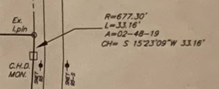
Posted by 4lane on April 16, 2019 at 1:48 pmHi, If I can indulge you all…I have a couple of general survey reading questions here. In this area, there is concrete highway marker at the point “C.H.D. MON.” At the right of it are coordinates. Does anyone know what “R”, “L”, “A” values represent?
Also, I assume the “CH” value is a bearing. If you walk 33.16 ft due S15?ø 23’09″W you will reach the pin above it. Is this correct? What does “CH” represent?
 Unknown Member replied 5 years, 3 months ago 6 Members · 10 Replies
 -
10 Replies

-

R is the radius of the curve, L is the arc length of the curve, A is the central angle (delta) for the curve and CH indicates the chord bearing and distance, basically the straight line between both end points.
Mike -

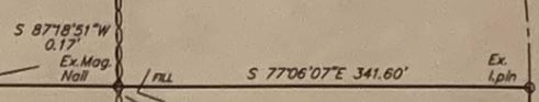
Wonderful, thank you! So, looking at this from right to left, if you walk 341.60 feet due S77°06’07″E from the lead pin, you’ll reach the next mark which is the Mag Nail. Correct?
I’m not sure what the bearing S87°18’51″W .17′ means, however. Is that reference to the exact location of the Mag Nail, somehow?
So, when I see
-

There is a deflection around that pin in this picture, if the other leg is 87 18 51. Simply add the two bearings together ( 164 24 58), and that is the angle you can turn if using a TS on the western point, back sighting the far western point (not shown). Turn that (angle Left) , go the 341.6 feet, and you should be bang on the pin, if its accurate.
-

From “Ex.I.pin” to “Ex.Mag.Nail” the bearing is North 77°06’07” West 341.60 feet. Face north and turn left 77°06’07” to face the direction of the line.
Bear in mind, can’t see the whole map, north arrow and what the leader line to the left might indicate so a view of the whole map could change my answer.
-
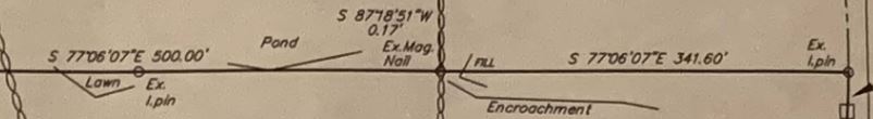
This boundary line I’m showing is pretty much a straight line for a 1/4 mile, so this is just a piece of it. Here you can see that deflection point, which is a pond. So, I’m tnisll not sure what S87°18’51″W .17′ means is referencing at that mag nail marker.
-
Since the bearings are the same on both side of the existing/found mag nail, I’m inclined to believe that the surveyor found the mag nail to be S 87?ø18’51″W, 0.17 feet of the actual corner. Basically the saying the nail is about 2″ off.
Mike -
Here is that whole side.

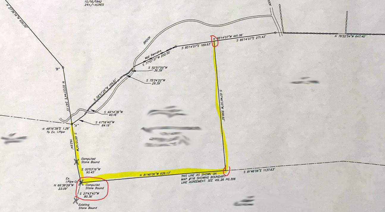
I’m looking to find those markers, and actually, more importantly find this area. I’d like to be able to find the following points, but it’s not clear to me how to track those spots down. Any help appreciated.
-

“…..In this area, there is concrete highway marker at the point “C.H.D. MON.” At the right of it are coordinates. …”
The map calls for an iron pin at the property corner, not a concrete marker. The concrete marker may, or may not, be adjacent to the iron pin. Or the concrete marker may be at the south end of the curve, at the point labelled “C.H.D. MON” on the map. Further, my experience with concrete highway markers is that they only roughly indicate corners of changes in alignment at best. So you may be measuring off a false point.
Just one more thing……..That map appears to be at least a few years old. It’s really common to only find a small percentage of old monuments of record. They just disappear one way or another with time. Even fewer are going to be sticking up so that you can see them when you walk by. After 20, 30 years out in the weather they blend into the background very well. Needle in a haystack as it were.
Best of luck.
-
“C.H.D. MON” is 33′ south of the iron pin, and has been there at least 80yrs. This survey is new and up to date, but yes, markers disappear. That’s why I’m trying to determine the locations (or how to navigate myself to the locations), noted in red circles below.
-

What state/jurisdiction you located?


Log in to reply.