
Activity Feed › Discussion Forums › Strictly Surveying › Astronomic Azimuths

Back in the late 60s & early 70s, Solars (altitude method w/ 1′ transit) were an almost daily procedure (sometimes several on the same day).
I have only performed a couple (2 or 3) Polaris shots (elongation), and they were only because I wanted to get the hang of it (after work w/ a beer or two).
I believe that my last Solar was the one I had to do as part of the U.S. Mineral Surveyor Examination (bring your own gear) in Reno Nevada back in 1980 (Wild T-16).
By that time, I had adopted an SOP that involved USC&GS/NGS Passive control for ALL projects, so Solars were not so important anymore.
Loyal

Mike …
An extraordinary claim needs evidence. I made a claim of higher accuracy solar azimuths than is expected. Attached is Starnet output listing file of my recent observations of a radio tower strobe light. Please give it a look, and note the global weight of azimuths, and the 95% confidence on the azimuths.
I have also included 2 examples of observation data reduction.
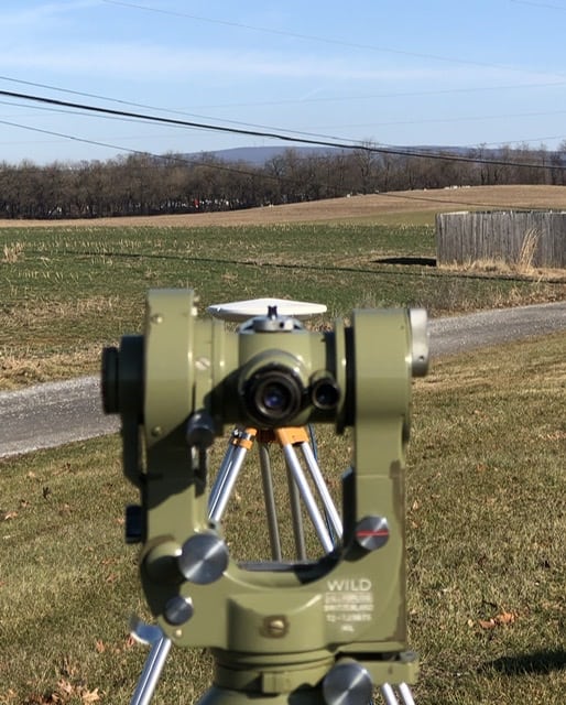
I did this survey specifically to see how well solar obs work when all of the details are addressed, and to learn what observing techniques are required. Please look at the Mils angle input in the excel sheet and that the micrometer is left at a single value, advancing the instrument by integer mils only. This is to addresses micrometer scale error. (My T2 has about 0.4″/minute scale error.)
It’s purely an academic endeavor. I repeated the survey 3x. The first running was not this good. After I wrote the excel sheet, and revised my procedure, the 2nd and 3rd return nearly identical coords of the strobe light (20-30 cm).
The real reason behind the survey was to see how consistent and accurate solar azimuths could be. So, at 8-12 miles, and a large number of azimuths (all 3 runnings have on the order of 100 sets), I figured the residuals would demonstrate statistical significance, not flukes.
(Stars, Vega, Fomalhaut, Antares, Procyon, Capella, Polaris, were observed in the 1st and 2nd running, to further check the strobe light position.).
Please give them a look. It’s just an appreciation for detail, and the azimuths and zenith angles tell the story. I’d be interested in comments.

I stand corrected. I reviewed Nolton’s list of papers (abstracts) and it’s clear with attention to detail azimuth accuracy on the order of a few seconds is achievable using field survey theodolites.
I erred because I based my opinion on my experiences with T-2 solars in the field (hour angle method), where no extraordinary procedures were implemented; just one set of D&R observations against targets often less than 1,000′ distant, tenth of second time accuracy using the hp41c time module that has undergone a month of the “Correct” process against WWV, lat-lon scaled from a quad sheet, and no observations within an hour of local solar noon. Typical results when compared to reality (2 NGS stations or equivalent tests) was 5-10″ with the occasional 15″ outlier especially near local apparent Noon or bad atmospherics.
I’m curious how you guys are achieving 5-10 times better accuracy and I suspect it’s procedural. Obviously multiple sets (6?) distributed around the plate, no observations above 30° altitude, and observer skill concerning pointing, accurate time coincidence ticks and low micrometer reading personal bias is important but can be ameliorated with practice. I doubt a magical observer can tighten things up much compared to a seasoned surveyor familiar with the process.
I’d like to pick your brains concerning procedures/equipment:
- Do you use geodetic grade tripods? They’re heavy. If not, do you avoid unstable setup situations?
- Do you shade the instrument and wait 20 minutes for it to acclimate, more if it just came out of the truck?
- Do you use a striding level to tighten the leveling of the horizontal axis? Or do modern Total Stations compensate for levelling error so a striding level is old school.
- Do you think a Roelofs prism introduces excessive horizontal pointing error and is not needed for the hour angle procedure where simultaneous observation of the vertical angle is not salient?
- Do you base your lat-lon on quad sheets? Does that introduce multi second errors? Using a handheld GPS to get within 30 feet +- sort of negates the concept of autonomy; might as well whip out your GNSS receiver.
- Concerning foresight targetry, are they free of phase error and stable? If a sight is not evenly lighted on both sides, the instrument man will tend to point toward one side. This phenomenon, called “phase”, can be reduced by using a target with a flat surface pointed directly toward the instrument. Concerning your experiment a tower strobe at 9 miles is certainly subsecond resolvable but with differential heating and wind loads may dance around several feet. A range pole @ <1,000′ distant beware, phase error can be considerable.
Your and the literature quoted above involve multiple redundant observations from many stations over a long time span which can be least squares resolved to 1-3″ accuracy. I believe it, but question whether a single solar observation (6DR&RV) to a moderately distant target using solar to determine azimuth is better than about five seconds @95% confidence level.
But that’s just me, I’m old school. Could be wrong.

I would like to add something for you and others about Realistic azimuth results. Lets take 1st order work;
we go to Classification, Standards of Accuracy and General Specifications of Geodetic Control Surveys”
and see on page 4 that 1st order work requires 2 nights with 16D&R each night with a Standard error of 0.45
seconds. The real accuracy of 1st order azimuth is around 1.5 to 1.7 seconds of arc.
One of the papers I referenced does say a SOLAR obs. (that means SUN) will be 1.9 seconds “Standard Error”
or Standard deviation if you prefer.
Where did you come up with “5 seconds at 95% confidence level” ?
Question for all surveyors reading this: Just how accurate of an azimuth do you require? Give it in seconds of arc
and with a 1, 2 or 3 sigma error.
JOHN NOLTON
More References on Astronomic azimuth and Instruments.
1). Astro-Azimuth Comparative Studies with Wild T3, Wild T4, and Kern DKM3 Theodolites. ( Note: this was using Polaris only or Stellar Obs.).
AIAA Paper No. 72-842 by M.F. Popelka Jr. and F.R. Ferren. Paper given at the AIAA Guidance and Control Conference, Stanford, CA./ Aug. 14-16, 1972
2).Wobbles of the Horizontal Axis of a Theodolite, by L.A. Kivioja and J.E. Pettey in Surveying and Mapping, Dec. 1973
- Do you use geodetic grade tripods? They’re heavy. If not, do you avoid unstable setup situations?
Good wood. Regular tripod.- Do you shade the instrument and wait 20 minutes for it to acclimate, more if it just came out of the truck?
Well solar azimuths the instrument has to be in the sun, so no shade. But, letting the setup sit for a while is important. Mostly because I think the thermal stability of the tripod is key.- Do you use a striding level to tighten the leveling of the horizontal axis? Or do modern Total Stations compensate for levelling error so a striding level is old school.
I don’t have a striding level. I level using the vertical bubble. The split image of that vial is far more sensitive and can be observed far more critically than the center vial. The split image can be used to level the alidade far better.- Do you think a Roelofs prism introduces excessive horizontal pointing error and is not needed for the hour angle procedure where simultaneous observation of the vertical angle is not salient?
I would like to use a Roelof. I don’t think for azimuth it’d be any better. I only observe the trailing edge. Reading the leading edge is far too noisy. The semi diameter is as good as center. I haven’t never obs the leading edge.- Do you base your lat-lon on quad sheets? Does that introduce multi second errors? Using a handheld GPS to get within 30 feet +- sort of negates the concept of autonomy; might as well whip out your GNSS receiver.
The point of this survey is to determine the coord of the strobe light, and the accuracy of azimuths. So, only OPUS or published points are occupied – in this example. I’m sure a CA code position from a hand held will be fine (3-5 m). And a true coord would be available, if not same day. 30 ft in latitude longitude pretty small impact. Xi Eta is much greater: can be more than 10 seconds! Astronomic latitude longitude is a big deal! Ignoring Xi Eta can be 20 seconds error, by my obs from when I didn’t include Xi Eta. In this survey Xi Eta Laplace goes from (7.3, -10,7, 8.9) to (1.8, -3.2, 2.7) That’s many seconds of latitude longitude!- Concerning foresight targetry, are they free of phase error and stable? If a sight is not evenly lighted on both sides, the instrument man will tend to point toward one side. This phenomenon, called “phase”, can be reduced by using a target with a flat surface pointed directly toward the instrument. Concerning your experiment a tower strobe at 9 miles is certainly subsecond resolvable but with differential heating and wind loads may dance around several feet. A range pole @ <1,000′ distant beware, phase error can be considerable.
Again, this example I’m observing a strobe light against blue sky to investigate azimuths. Job site conditions have their issues that can’t be avoided.If you looked at the spreadsheet, what is not apparent is target obs procedure. I obs the target D at least 4x, and R 4x at the start. Then at the end I re-observe D 4x and R 4x. So I point and read the target 16x. This has proven to be a big deal. At 10+ mi every time I come back to target I get 1-3 seconds different, and it’ll drift (+) and (-). So it’s atmospheric. I average the 4x D from start and end, 8 readings. And all 8 R readings of the target.I generally only take one set. With multi foresight, every foresight reading is to a different plate mark. I have taken 4-6 sets, in rapid succession and the azimuths are nearly the same. So to take 4 true sets, each should be separated in time: AM PM, or next day.As in all things, when it’s critical there has to be redundancy. So repeat as necessary.The survey that I presented is intended to: a) determine the coord of the strobe light, b) evaluate the azimuths.
Re: your question about individual azimuths, not adjusted azimuths.
so today I did a quickie. Just setup read one set, per the procedures I described. This obs is not in the adjustment. It’s unadjusted azimuth, right out of the spreadsheet: T4-strobe
95-48-08.2
the azimuth from the adjusted net is:
95-48-09.9
I’ve been doing that for quite a while. And that’s why I contend these days. UTC time, Xi Eta Laplace, solar azimuths are very good. Not 10-20” as has been chatted up for a long time.
Time UTC UT1 GAST GMST
Universal Coordinated Time
Universal Time
Greenwich Apparent Sidereal Time
Greenwich Mean Sidereal Time
In several sources of sun and star ephemeris data, The values are RA Decl. To use RA you need Greenwich Apparent Sidereal Time. Not GMST!
For celestial observations, depending on software, you may need to retrieve GAST of UT (UT1) Universal.
I have made the mistake of trying to use GMST. And that??s a mistake that??s small enough to go undiscovered.
So, hopefully the software you??re using deals with this.
Dave Lehman was the person who was the presenter at the two Astro Observations workshops at NGS Corbin. He had worked at DMA and IAGS, as well as at NGS. He passed away several years ago unexpectedly. We had corresponded quite a bit about astro obs, and he gave me a copy of a paper he presented at ACSM in 1987 that is very interesting, basically his premise was you can determine latitude, longitude, and azimuth simultaneously by observing angles to random stars (as long as you have ephemerides for the stars). Not high accuracy lat/longs, but a few seconds. This is similar to “Black’s Azimuth” which was described in the Empire Survey Review in 1951 (and mentioned in Bomford’s Geodesy).
I have a number of pdf’s pertaining to astro observations, and wanted to make them available to anyone who is interested. So I placed them on my ftp server…
login: Astro (case sensitive)
password: Polaris2020 (case sensitive)
If anyone has any other good docs, I would be happy to host them there.
I’m not doubting your results; you’ve provided indisputable data that shows an accuracy of 1-2″ or so. My worst case of 10-20″with 5″ or so typical is merely an observation of the accuracy I obtain when doing solars (1 D&R obs) in the course of a mundane field traverse, with shorter legs, some shots near solar noon (>+- 1 hour) with no waiting for the instrument setup to thermally stabilize, targetry a mix of plumb bob strings, range poles & prisms, etc.
Thanks for responding to my questions, may I followup?
- Yep, a good heavy wooden tripod outperforms metal ones. It’s a good thing you can setup in stable terrain for your observations; I must accept whatever the terrain allows and observe quickly before settlement and torsion degrades the observation.
- Concerning instrument shading I was commenting on my field operations, where it may be several observations in the traverse are in tree cover or shaded by nearby terrain, then entering a meadow with clear sky suitable for a solar, which may be tens of degrees warmer and suffer from direct sun on one side of the setup. Obviously a solar shot must be done with the instrument in the sun, and allowing time for the instrument setup to stabilize is important. Not enough time to do so in my commercial traverse situation.
- Striding levels are utilized to reduce errors in trunnion axis perpendicularity compared to the the horizontal plate axis based on plate bubble orientation. They have nothing to do with vertical angle errors except secondarily as you posit, a coincidence split bubble on the altitude axis D&R is effective. Personally I’ve never used one and suspect it’s not a factor in modern instrument observations if the instrument is well calibrated.
- Obviously a Roelofs prism performs no better than a simple sun filter if only observing the sun’s leading/following limbs, and is only useful for a simultaneous check for altitude to look for timing blunders.
- Agreed that the lat-lon of the observing station introduces minor errors unless it’s hundreds of feet.
So I’m puzzled why my solars are so sh*tty compared to your super good strobe location after hundreds of obs from NGS stations surrounding the target. I deny I’m a lousy observer through the ‘scope and strongly suspect the problem is I neglected Laplace corrections for 5-20 mile traverses, not available back in the seventies. As you opined, that introduces 10″ or more into the results.
One final question, why do you consider leading limb observations inferior to trailing edge?
not transforming geodetic to astronomic (Xi Eta) can be a big source of grief when the values are large. I learned the hard way. In my area Eta varies by over 7? in less than 10 miles.
And it takes time. On small project you can??t easily spend the time on one setup. Or have the weather when you need it. Or the T2, because TS is how we work now.
The leading edge shows up like a surprise. So I??m always late on the stop watch. And it??s just not worth it. The trailing edge is in view in the sun as it crosses the cross hairs like a sweep second hand. Just better hand eye coordination. And semi diameter is not in question, so there??s no uncertainty in the diameter. SD is as good the plate marks in the gun. If you looked at the residuals in the spreadsheet you can see that the trailing edge was captured. The leading edge has no information.
any class/workshop on solar is heavy with calculation, not nearly as much on observation. I haven??t seen any real software since Elgin & Knowles, 1985.
Part of the problem is before 1980, we were told to expect 10+ seconds best case. In college level textbooks there??s no reason that sun obs have any mathematical reason to suffer, except that Xi Eta Laplace for everywhere wasn??t available, unlike now with NGS DEFLEC.
Given that accurate time is easier to curate, Xi Eta Lap. is modeled for everywhere, we??re all getting better with tools like Excel, we have to revise what is possible and practicable. 10+ sec accuracy is obsolete.
I have a tiny GPS receiver with an LED pps output. Absolute time. And it took a long time to create my spreadsheet, over a year of various versions and improvements. And I set out to see what is practicable.
The strobe light is visible across the whole Shenandoah valley, so there??s no skimming terrain. I can choose the setup location. I can get 1cm opus solution, collecting gps data while making the observation, so time on station is efficient. The strobe is far enough away that +/- a couple feet is still only 1-2 seconds. So I became obsessed. I??ve used Starnet since v.1 came out in the 80s. I was curious to see if I could establish an intersection station as well as an agency. And I have the gear: Ashtech receivers, and T2 (T3, T1, T16…).
as I said before, first go around I was happy with a bunch of seconds residual. But noticed that I had good one and bad ones, per Starnet. (Gotta love Starnet) little things like using the vertical level vial to level the gun. Which at least gets the standing axis true. The trunnion axis can??t be bad, it??s a T2! Observing the target D and R, multiple times at the start, observing the target multiple times D and R at the end, averaging D start and end, and R start and end, that is a significant improvement on 10 mi sightings.
?You??ve got to accentuate the positive, eliminate the negative.?
And these days, solar obs may not have a place in the work flow.
I refer to my survey of the strobe light as a “civil reenactment”. More nostalgia than productive.
And single handed, I can’t leave gear a 1/2 hr drive away. So the strobe light was sort of plan B. I’d rather have 10 mi OPUS or published point pairs. But I’ve only managed that once.
and winter is good solar az season. The sun is never too high.
A few comments about possible error sources. Nowadays time should be a very small error source.
1) note that what is needed in the reduction is astronomic latitude and longitude. So the xi and eta are not just for computing the laplace correction, they can be used to convert a geodetic position (i.e. from GPS) to an astronomic position. The effect of an error in latitude is minimal when the azimuth to the star or sun is 0° or 180° (i.e. on the meridian). An error in longitude (and time) is minimized when the object is at elongation, which is the opposite of being on the meridian. So both can’t be met at the same time, but polaris makes a very good target when at elongation, which is why it is best to observe polaris at elongation and time can be off by a few seconds without causing any significant error, ditto with latitude and longitude.
2) inclination of the standing axis: this is an error that is NOT corrected by taking D+R shots. The magnitude is m*Tan(V), where V is the vertical angle (not zenith distance) and m is the mislevelment in seconds. My (newer) T2 has a pendulum compensator (similar to the compensator in an automatic level), this can be used to either get the instrument close to being level, or, more practical, to measure the inclination of the vertical axis. Procedure with a compensator is to set the scope at any vertical angle, turn 90° left from the object (sun, polaris), read the vertical circle. Then turn 90° right, read the vertical circle. Take the difference, divide by 2, that gives m. This is done after each set. A T2 has a bubble with a sensitivity of 20″/2 mm division on the bubble. If the altitude of the sun (or polaris at 40° latitude) is 40°, and the bubble is off by 1.5 divisions, then the azimuth will be in error by 25″, and the only way to correct that is by the above formula. If using an older T2, without a more sensitive striding level, it can be difficult to get it level enough to reduce this error to a negligible amount. I have a T3, which has a bubble sensitivity of 6″. I have in the past used a different T3 that had a calibration of the spirit level bubble and I would carefully record the bubble position after every position when doing polaris. I also have a Trimble S6 and a Trimble SX10, both of which have dual axis compensators supposedly accurate to 0.5″, but I have not yet done any astros with these instruments, although I plan to when the weather is warmer. What I really want to try is to use the SX10 for a polaris observation, it does not have a telescope to look through, it is all done by video. Not sure how well it will work, but I think it will at least work with the moon for lunar azimuths.
#2 can be a very significant error source unless the instrument has dual axis compensation. And as I said , IT IS NOT ELIMINATED by taking D+R.
I very much believe like Larry that a solar can be observed to an accuracy better than 5″ without too much effort. Time is critical (easy to get), accurate ephemerides are available (I use USNO MICA or the astronomical almanac), and modern instruments can greatly reduce the error from mislevelment.
Well, if the GNSS systems ever go down (it could happen, either by hostile attack in space, jamming, or by a massive solar flare) then astros will be king again. Not likely to happen , but the possibility exists.
I level using the vertical circle vial.
I bring the halves into coincidence, rotate 180. Then the vertical vial will no longer be in coincidence. I cut that in half with 1 foot screw. Realign the vial. Repeat that 2-3 time until the vial remains in coincidence in F1 F2. Rotate 90 and repeat the process using 2 foot screws.
when it’s ‘level’ the split image remains in coincidence in all directions. And I keep an eye on it during the obs. A very small misalignment in the split image image of the vertical vial is addressable, while imperceptible in the long horizontal vial. I do the exact same Procedure with T3. With TS, I lock the scope and level so that the vertical angle is unchanging when rotated
When the vertical vial is stationary when rotated, the hor vial is stationary too. That’s standing axis, not trunnion axis.
You know, your solar az might have been observed better than you think. It sounds more like the data reduction is at fault, than the field obs.

Log in to reply.