
Activity Feed › Discussion Forums › Strictly Surveying › Monuments off a little bit
Monuments off a little bit
Posted by Bruce Small on July 9, 2021 at 4:40 pmSomeday I hope to be this accurate with my surveying.
 chris-bouffard replied 2 years, 9 months ago 22 Members · 35 Replies
- 35 Replies


Hot dawg, somebody needs to check what the interns are annotating before it goes out the door.

First I ever saw notes like this was in the Tucson area. Now I see it here in California and really wonder what these surveyors are thinking.

Said it before, Mass Land Court would require notations like that for the submittal plans. Not sure if they do any more.
Some of that carried over into non-registered work too, and is how many believed and/or were taught it should be done.

So if I resurvey L6 and accept the monument can I show the notes on the plat being off?
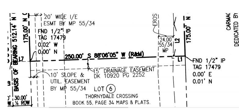
1/2″ pipe (an original?) is “off” from the real corner .01′?
Modern life is silly.
And if you notice, the R&M measures 250.00′ along an east-west line but the notation shows the east end of the line 0.00’E and the west end of the line 0.02’W.
Am I missing something?
 Posted by: @jph
Mass Land Court would require notations like that for the submittal plans.
I am genuinely curious – if the 1-2 hundredths “differences” weren’t dimensioned/noted, how would the Court know the monuments were “off”? Is positional tolerance not recognized?
“…people will come to love their oppression, to adore the technologies that undo their capacities to think.” -Neil Postman
Exactly. We had a young Surveyor that was doing the same thing. I asked him one day what it meant. Are you using your positions or the ones that are monumented? He quit doing it. Interesting he came from Arizona. They must teach them to do it that way there.
It’s not necessarily, off.
Their thinking as I interpret it: They have a plan of property whose boundary lines have been determined by the court, and are inflexible. (I’ve heard that that’s changed some recently). They want you to run in your traverse, and then rotate your fieldwork onto their plan/math, and then show the differences between record and field for each monument.
Your submittal plan also shows the traverse and monument sideshots with B-D. Field notes and coordinates are also submitted. So, will they notice? Maybe
As said, this is how it was done up until the early 2000’s. I’ve no idea how it works now.
(if I mis-remembered or mis-represented something here, I’m sure that some MA surveyor will let me know. It wasn’t intentional)

I get plats with “x,y” to “true corner”. That is incorrect. A corner is something monumented on the ground. An xy delta is not a true corner but a figment of one surveyors theory, the exact opposite
Interesting, thanks for the breakdown. That’s got to be a pretty unique experience.
That’s a lot of raw data to submit to a court. I’ve submitted that sort of thing to public sector clients along with reduction reports and surveyor’s narratives, but never to a court…at least not yet.
“…people will come to love their oppression, to adore the technologies that undo their capacities to think.” -Neil PostmanIt was sent to the Engineer for the Court (Surveyor). They were usually pretty easy to deal with.
The most bizarre part was that they would take your plan, (on linen up to the late 90’s, I think), and then re-draft the plan once it had been through court and decreed. And they’d put your name on it. No stamp or signature, obviously.

It is sad we must still deal with such foolishness. The world of reality is never set in stone when it comes to measurements. Forcing one’s measurements to agree with some mythical, one-time measurement is silly. Those of us in PLSSia deal with this in virtually every case as our measurements today will never (never say never) agree absolutely with what the Original Contractor did well over 100 years ago with a completely different method. We are doing well if we can hit a 20 year old bar within one or two hundredths. We are on the bar and that is the only thing that matters. The bar is the corner, not our mathemagical, one-time shot.

Hand drafted in cursive I hope.

Back in the 80’s construction boom I worked under a female LS, afresh hire, and she supervised 8 crews with one assistant, a guy from the UK. Both were clueless, she had no problem calling the center of a 100+ year old field stone off by a few hundredths in each direction and he did the set up work for me to stake steel for a shopping center. As I was trying to set my points, nothing was making sense so I dropped back and checked his dimensions against the structural plans and found insane differences. I packed up and drove an hour back to the office to talk to him and figure out what the problem was. Long story short, he scaled the dimensions used in the calcs versus using the design dimensions clearly shown.
Needless to say, neither lasted long, but, the scary part is that she is writing books of surveying, giving lectures for PDH’s and has worked in a pretty high position for the state. 30 years plus later, I still laugh.

Worked with a “super-measurer” in the 80’s (Upstate NY) we were staking building corners (each and every one for Condos) in the footing with small concrete nails (heads were 0.015′ diameter+-) with a T-1 and steel tape in the middle of Winter. On one of the corners we determined the location and I drove the nail, checked it (keep in mind also that I am holding the dumb end by the ring on the concrete against his pulling the tape as hard as he could (felt like he was trying to pull the ring through my finger) about 20′ or so. He reads the vertical, taps it all into his calculator and says “move it to me a thousandth” I figure he’s yanking me, so I start getting up to move to the next point, says “where are you going, I said to move that” – “You’re kidding with me, right” “NO, MOVE IT”, so I tap behind it with the hammer and got through the process, holding the tape about a thousandth closer to him. Measure, read vert, tap, tap, tap – “Well, I guess that’s good enough.” Remember, it’s dead of Winter and he was not compensating for temperature either, even though it was short distances. Later on found out the he would put existing building offsets on his surveys out to 0.001′, even though he wasn’t the one stamping, boss would make him change it, and he’d complain that the boss didn’t care about accuracy.


We have a guy around here that always likes to do that crap. Was the rod perfectly plumb, did he use tripods over every corner, was all his gear calibrated correctly? It’s a complete embarrassment. About the only saving grace is that most clients don’t know what they are looking at when you hand them the map.
MikeIt would have been worse if he told you to move it a hundredth. Don’t you hate it when you hit a rock or the concrete chips?

Maybe both a big issue on this plat, but this surveyor shows a fundamental lack of understanding. Is he/she minimally qualified?
Log in to reply.