
6th
my challenge is to the terminology TRUE CORNER----TDD
A LITTLE BIT LIKE TRUE LOVE--
> Stay in Texas because it's apparent you cannot follow California maps
Hey, I'm just looking at the map that YOU posted and the notes that ITS surveyor put on it.
Well There's Your Problem
"Engineer's Certificate"
> Hey, I'm just looking at the map that YOU posted and the notes that ITS surveyor put on it.
It's pretty easy to follow the guys map. Here's a few links
http://survey.dpw.lacounty.gov/landrecords/Tract/MB1050/TR1050-043.pdf
http://survey.dpw.lacounty.gov/landrecords/Tract/MB0701/TR0701-019.pdf
http://survey.dpw.lacounty.gov/landrecords/Misc/MR034/MR034-010.pdf
http://survey.dpw.lacounty.gov/landrecords/Tract/MB0098/TR0098-005.pdf
http://survey.dpw.lacounty.gov/landrecords/Tract/MB0117/TR0117-008.pdf
http://survey.dpw.lacounty.gov/landrecords/parcel/PM064/PM064-018.pdf
http://survey.dpw.lacounty.gov/landrecords/Tract/MB0107/TR0107-046.pdf
Kent
> Hey, I'm just looking at the map you posted, Paul, which was this:
>
> 
>
> Now, I realize you're in California, but as I read that subdivision map, the subdivider was laying out Lot 5 along the existing S'ly line of an existing parcel and specifically annotated the 30 ft. wide strip as "NOT A PART OF THIS SUBDIVISION". That suggests that the 30 ft. strip had already been conveyed.
Whenever a portion of land is delinated on a subdivision map in LA County that is not a part of the subdivision but is shown to establish lines or points that is needed for the subdivision establishment, the words "NOT A PART OF THIS SUBDIVISION" have to be placed in those areas.
That south line needed to be established because it was common to the subdivisions north line and to do that, other monuments of other tracts needed to be established around that area. The civil did a good job of doing so.
> So, if that was in fact the case, the 2 in. iron pipe that the surveyor set to mark the common corner of Lots 4 and 5 couldn't be an original corner of the 30 ft. strip
I agree that the 2" pipe is not an original corner for the 30 foot strip, but a 0.34' witness? Come on Kent..
Take a look at the link to the Montezuma Tract I posted. Book 34 page 10, M.R. The subdivision is a portion of Lot 21 of that tract.
Another thing is that a lot of the deed cut parcels in my area were never monumented when the deed transfer happened. It's probably the same with that south line of that strip. It was probably just a deed cut that never got monumented until an earlier subdivision, prior to the 1982 one, was created that finally established the common lines and placed a monument to mark them.
>That "other evidence" may include record dimensions.
I bet you find a lot of monuments off by a few hundreths Jim
Oh, Christ, you're going to make me do your work for you? Okay, but it would have been simpler for you just to have said WHY you thought that the 2 in. iron pipe at the NE common corner of Lots 4 and 5 actually defined the line of the land subdivided, i.e. marked the true corner of the parent tract instead of merely a witness to the common lot line that would have to be prolonged or shortened as the case might be to intersect the true boundary of the parent tract.

> I bet you find a lot of monuments off by a few hundreths Jim
Rarely off by a few hundredths, but often off by a couple of tenths.
> "True Corner" - WTF?
> ?Really - True Corner??
>
> I guess the good thing is - is that he didn't set a new monument to locate the TRUE CORNER
>
> I guess surveyors are forgetting the theory of honoring existing monuments and the basic premise of what a monument is and what monuments represent
>
> - MY OPINION IS THAT THE GUYS THAT DO THIS TYPE OF THING ARE JACKWAGONS - THEY THINK THEY ARE BETTER SURVEYORS THAN THE ONES BEFORE THEM, ALL THEY ARE DOING IS CREATING PROBLEMS FOR THE CLIENT, THE ADJOINER AND THE PROFESSION.
>
> -------------------------------
>
> Not to hiJack this thread -but- Here is one I was working on last week
> Same sort of situation.
>
>
>
> FYI - The surveyor that prepared this plat had his license take by the BOR several years ago, but the problems he created will longer on for years and years to come.
>
> -
6th,
With a pincushion or with very sound reason to do so, I will call a monument off by whatever amount is appropriate. But 0.02'by 0.05', that's nuts.
SJ:-(
Not enough information, it would appear.
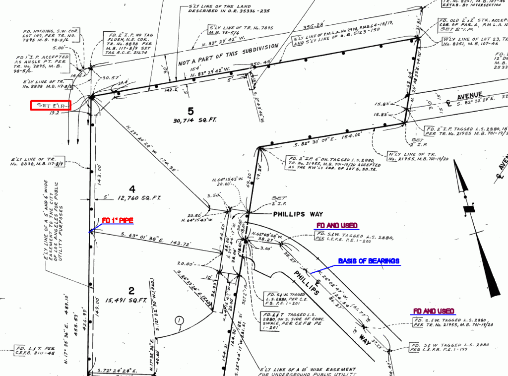
Okay, so the land in the vicinity of the NE common corner of Lots 4 and 5 of Tract No. 40968 (the 1982 surveyor's work) is all out of land formerly known as THE MONTEZUMA TRACT as shown upon the 1887 map of the same.
In 1924, a portion of Lot 57 of THE MONTEZUMA TRACT within the boundaries of land designated as Tract 7895 was subdivided into lots.
The 1982 surveyor's map of Tract No. 40968 indicates that he found a 1 in. iron pipe that he thought to be the same 1 in. iron pipe shown on the March, 1924 map of Tract No. 7895 as marking the angle point on the South line of the tract, the same marking also an angle point on the South line of Lot 150 of the lots into which Tract No. 7895 was subdivided in 1924.
Later, in August, 1924, a map of land adjoining Tract No. 7895 on the South known as Tract No. 8251 was prepared from a survey made by a different surveyor and recorded.
The 1982 surveyor claimed to have located the common line of Tracts No. 7895 and 8251 from some perpetuation of the centerline of Avenue 52 as laid out in 1924 when Tract No. 8251 was subdivided and from the 1 in. pipe taken as the original angle point on the South line of Tract No. 7895.
In 1975, certain land was subdivided as shown on Parcel Map L.A. No. 2988. That map makes reference to land described in Doc. No. 3776 recorded 08/26/1964 in Los Angeles County that purports to define the boundaries of the title of the subdivider of P.M. L.A. 2988.
The 1982 surveyor indicates that he found an old 2" x 2" stake that he considered to mark the most S'ly corner of Lot A of the 1975 subdivision shown on P.M. L.A. 2988. He used this 2"x2" stake for the NE corner of Lot 5 of Tract No. 40968 as surveyed by him in 1982.
So, the question is whether the 2 in. pipe shown on the 1982 subdivision of Tract No. 40968 as marking the NW common corner of Lots 4 and 5 is actually on the S'ly line of P.M. L.A. No. 2998 or not.
Without additional information it would appear to me that can't be determined. P.M. L.A. No. 2998 doesn't appear to tie to any monuments shown on the South line of the 1924 subdivision of Tract No. 7985. One key tie would probably be that to the 1 in. iron pipe that the 1982 surveyor considered to mark the angle point on the South line of Tract No. 7985.
Jim
Thanks for linking my CLSA thread. I was about to launch into that mess but you saved me the trouble. Last time I checked there were 100 replies to that thread with no consensus, where there is an original undisturbed monument that happens to be 7.5 feet from where anybody intended it to be. How far is too far off for a monument to be called off? That's supposed to be a bad queston, according to some people, but I think at some point there's a matter of allowable error that comes into play and the people that claim that pincushioning is evil have to rethink their basic position.
That being said (did I just use that cliche?) I still don't have that situation resolved because my client doesn't give a darn and is willing to accept the pipe that was set 7.5' in error just to get the property sold.
Jim
> That being said (did I just use that cliche?) I still don't have that situation resolved because my client doesn't give a darn and is willing to accept the pipe that was set 7.5' in error just to get the property sold.
Cousin Steven, wasn't the situation that the parcel would be smaller than the minimum size allowed in your jurisdiction if the marker in question were to be adopted as the true corner? If that is so, what exactly would the seller have to sell?
Cousin Kent
That's a potential problem that might have no consequences. If everybody agreed that the original undisturbed pipe is the corner and the subject parcel is not 100,000 square feet but something slightly less than that, I have not been able to think of a problem that would concern a buyer of the subject property unless the County changes the zoning of the property sometime in the lifetime of future generations to be half of that minimum size and they don't have enough area to re-divide the property. It's a legally created parcel with a house and necessary appurtenances on it that nobody could ever challenge as a legally saleable piece.
Thanks for the offer Kent
> Oh, Christ, you're going to make me do your work for you?
I appreciate the offer and the prayer Kent, but The Lord and I can take care of anything that comes my way.
> Okay, but it would have been simpler for you just to have said WHY you thought that the 2 in. iron pipe at the NE common corner of Lots 4 and 5 actually defined the line of the land subdivided, i.e. marked the true corner of the parent tract instead of merely a witness to the common lot line that would have to be prolonged or shortened as the case might be to intersect the true boundary of the parent tract.
I did. It was set by the 1982 tract and I found it.
>i.e. marked the true corner of the parent tract instead of merely a witness to the common lot line that would have to be prolonged or shortened as the case might be to intersect the true boundary of the parent tract.
The parent tract can not be retraced to any point of certainty in 2010. It probably could not be retraced in 1910 with absolute certainty. Corners for any of the lots of the Montezuma Tract may or may not have been set by the Mc Clure Brothers in 1887 it's anyones guess.
When you get a lot survey to do in Texas, like one such as lot 4 of the 1982 tract, do you reinvent the wheel doing it? I am not being a smart ass or trying to insult you, but do you stay within the limits of the subdivision the lot is in, monument wise, or do you survey to such a point that you recreate the subdivisions exterior limits the lot is in by recovering monuments all the way back to sovereign?
Not enough information, it would appear.
> Okay, so the land in the vicinity of the NE common corner of Lots 4 and 5 of Tract No. 40968 (the 1982 surveyor's work) is all out of land formerly known as THE MONTEZUMA TRACT as shown upon the 1887 map of the same.
Which was created out of two tracts...

So to do it 'correctly' Kent, the survey would have to go back to the original patent or land grant.
> Without additional information it would appear to me that can't be determined. P.M. L.A. No. 2998 doesn't appear to tie to any monuments shown on the South line of the 1924 subdivision of Tract No. 7985. One key tie would probably be that to the 1 in. iron pipe that the 1982 surveyor considered to mark the angle point on the South line of Tract No. 7985.
P.M. L.A. No. 2998 was a record data Parcel Map not one done from a field survey. The only monument requirement for a 1975 Parcel Map done by record data was to note two monuments that were also of record.
Any Parcel Map done by record data is basically useless.
Hey - I'm just say'n
I was going to post only text concerning this - but I figured some out there wouldn't believe me. Thus the reason for the pic upload.
There are guys out there today giving fallings from existing markers and monuments that indicate that those points are off by minuscule amounts.
The problem is - it's getting worse.
Not enough information, it would appear.
> > Okay, so the land in the vicinity of the NE common corner of Lots 4 and 5 of Tract No. 40968 (the 1982 surveyor's work) is all out of land formerly known as THE MONTEZUMA TRACT as shown upon the 1887 map of the same.
>
> Which was created out of two tracts...
>
> So to do it 'correctly' Kent, the survey would have to go back to the original patent or land grant.
Actually, all of the land that you're dealing with appears to be out of Lots 57, 21, and possibly 22 as shown on the 1887 map of the subdivision of THE MONTEZUMA TRACT. That is evidently the point at which the chains of title of all of the presently adjacent parcels trace title back to common source. So the true boundaries of the parcels that you're dealing with were created by subsequent transactions.
If you examine the 1924 subdivisions of land known as Tracts Nos. 7895 and 8251, you'll see that both call for the identical survey monuments, defining the common line of Lots 21 and 57 of THE MONTEZUMA TRACT, so any confusion originated afterwards.
One of the key ties that would show the correctness (or not) of the 2 in. iron pipe found at the common corner of Lots 4 and 5 of Tract No. 40968 is probably that to the 1 in. iron pipe that the 1982 surveyor found. He apparently considered to mark the angle point that was shown on the 1924 subdivision maps as having been marked by a 1 in. iron pipe.
Thanks for the offer Kent
> The parent tract can not be retraced to any point of certainty in 2010. It probably could not be retraced in 1910 with absolute certainty. Corners for any of the lots of the Montezuma Tract may or may not have been set by the Mc Clure Brothers in 1887 it's anyones guess.
Well, if you look at the links you kindly provided, you'll see that the true North line of the land subdivided in 1982 is probably controlled by the segment of the South line of the 1924 subdivision of land known as Tract No. 7895. In 1924, two different surveyors reported finding the line which they considered to be the common line of Lots 21 and 57 of THE MONTEZUMA TRACT marked by a 1 in. iron pipe and a 2 x 2 redwood hub.
The 1982 surveyor reported finding a 1 in. iron pipe at the angle point that is shown as marked by a 1 in. iron pipe on the 1924 maps, which suggests that he had recovered the same corner.
The 1982 surveyor does not indicate that he searched for any other evidence of the common line of Lots 21 and 57, but apparently constructed it from ties to the centerline of Avenue 52 shown upon the 1924 subdivision known as Tract No. 8251.
> When you get a lot survey to do in Texas, like one such as lot 4 of the 1982 tract, do you reinvent the wheel doing it?
Well, I'd never heard of making a survey correctly as being called "reinventing the wheel". The object of resurveys is after all to keep the wheel the same. I can understand why you guys feel as if you have to take short cuts out there. Time is, after all, money. But isn't there some danger in turning boundary surveying into a quickie exercise that doesn't really answer the relevant questions?
0.34' ???
No one I've worked for wouldn't hold that and go on.
I've been reading all this since it started.
If someone calc'ed numbers to determine that elusive 0.34' my first question is going to be: "how many decimal places were used originally vs. how many used to determine it's off?".
We all know it can make a difference. When I first started doing the i-man duty, someone sent me a 3 point resection to do. First by hand before I grabbed my DC. I did so and my closure(s) was/were horrible. I was using the standard Windows calculator which carries an enormous number of decimal places. When I cut that down to 4, maybe 3, decimals wow did that make a huge difference. Suddenly my calc'ed point fell into nearly exactly where the observed point fell.
Just musing.
E.
Eric
> 0.34' ???
> No one I've worked for wouldn't hold that and go on.
The lath author called the 2" pipe South by 0.34'. My survey, using subdivision monuments that relate 'directly' to the pipe, finds (mathematically) the 2" pipe about 0.2' NE.
What is being represented by this 6" difference is the error between street control that the two surveys came off of compared to record. At first I thought that the lath author came in from the street on the west, but I have changed my position on that and I am POSITIVE that the lath author came in from Silverwood on the north..Here's a picture

Here are the reasons why I know that..
1. Lot 5 of the Tract I am surveying did not have a survey done. If one had of been done by the lath author the owner of that lot would have mentioned it when we were there and in conversation with him.
2. Coming in from Silverwood is a lot easier than coming in from the street on the west, Wildwood Drive/Silverwood. Most So Calif surveyors will take the path of least resistance, it just makes sense.
3. The assessors map shows a 'land hook' between the 30 foot strip and lots 147, 148 and 149. The lath author was surveying for one or more of those lots. If he was surveying for lot 26 that abuts the 1982 subdivision he would not have been comcerned about the 2" IP to call it out being 0.34' south since it would have been just a reference monument to the east line of lot 26.
Actually a 6" difference in street control in this area is not that bad at all considering the age of the subdivisions, the terrain difference and the location of the control on both streets. Kent's having a big problem of accepting an original tract monument, why, you're guess is as good as mine.
Now...if the street control is displaced +/- 6" from record, whats the golden egg of control to use? Is Silverwood control the gold nugget? Is Phillips Way?
This is one reason to accept the old monuments because no one can be sure that the control they are working with is the best control to use.
My thoughts as I do some wash..