
Yolo Base Line 1881
This tale is kind of long, and it’s just beginning, so first a little background:
In 1881 USC&GS surveyor George Davidson measured the Yolo Base Line to anchor the western end of the 39th Parallel Survey, a triangulation network that eventually spanned the continent. The Yolo Base Line is considered the most accurate base line measured in the 19th century, and some novel apparatus and techniques were used in its measurement. Its southern terminus is about 3 miles from where I live, on agricultural/riparian land owned by the University of California.
I’ve been aware of the line for the last 20 years or so, have visited both terminal monuments several times in that span, have skimmed some of the pertinent documents, and have always had it in the back of my mind to dig deeper into its history. But I never quite got around to doing anything about it until a phone call came in out of the blue last week. The caller was a lady who’s a history enthusiast. (Monica B., if you’re reading this, that’s you!) She heard about the line and became interested in writing a book about it. She got my name somehow, and called to ask if I could shed any light on the matter, particularly helping her interpret some of the terminology used in the historical record. That was enough to revive my interest in the subject.
I reviewed a couple of the USG&GS reports, and — reading more closely this time — saw that the Base Line measurements included stones set at every full kilometer of the 17+ km line, plus 9 “fence stones,” presumably set wherever the line encountered a fence. (I haven’t yet located a detailed description of either the kilometer or fence stones, but I have a lot of reading to do yet.) The 1883 Report of the Superintendent of USC&GS shows the measurements to these stones:

(The text is a bit hard to read here, but for those interested the report can be found on this page.)
Although the positions of these intermediate marks aren’t in the NGS IDB, the endpoints of the Line — YOLO SOUTHEAST BASE (JS4578) and YOLO NORTHWEST BASE (JS4571) — are. Last night I took the published positions of the endpoints and, using the distances shown in the table above, calculated positions for the intermediate points. I loaded these into the Triumph-LS that I have as a demo.
This morning I went into the field. First I visited YOLO SOUTHEAST BASE, both to get a couple of photos and to make sure I got the coordinates loaded correctly. (I hadn’t, as it turned out — not sure what happened, but I had to run back to the office to reload them.) Here’s a photo of the tower that was built over the mark sometime prior to 1927:

(The disk in the side is a bench mark that USGS installed at some point.)
When I first saw this monument in the early ’90s, it had a rickety and heavily-weathered 2×4 railing jury-rigged around the top. Evidently someone in the pre-GPS days had occupied the top mark with an instrument.
I’d never seen the top, though, so today I climbed up. I didn’t have a ladder in the truck, but I did, of course, have a surveyor’s stepping stool:

Here’s a shot of the mark on top of the granite monument:

And the view from the top, looking generally toward YOLO NORTHWEST BASE:
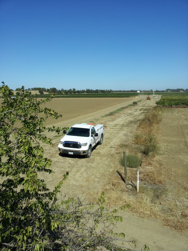
While I was there I also recovered one of the nearby RMs, then headed off in search of intermediate stones.
The Base Line is, for the most part, heavily cultivated, so I’m skeptical that the full-kilometer stones have survived. There may be exceptions, but for today I decided to concentrate on the fence stones.
The first one going northwest falls, according to Google Earth, in a heavily-used county road, so I didn’t bother looking for it. The next one, though, looked promising — Google Earth indicated that it fell very near an existing fence. I drove up to the site, pulled out the RTK unit (connected via IP to CSRC RTN station UCD1), and staked out the position. Setting the receiver aside, I pushed a probe into the ground and got a distinctive *tink* just a few inches down. Assuming this to be a rock, I grabbed the shovel anyway and started digging. It was, in fact a rock, but it was this rock:

I took an RTK shot on it, and later calculated it to miss my record position by 3 cm for distance and 14 cm for line. Ridiculously close, given the many error sources at play.
Alas, my initial success was not to be repeated today. The location at the next fence stone offers a modest possibility, but the ground was too hard to probe more than an inch or so. (We need some rain!) The next one after that is on private land, so I want to contact the owner before poking around. And the last one I tried to day was another possible-but-unprobe-able situation.
I spent pretty much the whole day on this volunteer project, and I don’t know when I’ll be able to get back to it. But having channeled Jerry Penry all day, I think I have the bug.
P.S. For a detailed description of the base line measurement apparatus and its application, see the Report of the Superintendent for 1882 from the site linked above.


Log in to reply.