
Activity Feed › Discussion Forums › Strictly Surveying › I hate this
I hate this
Posted by plumb-bill on February 16, 2021 at 3:53 pm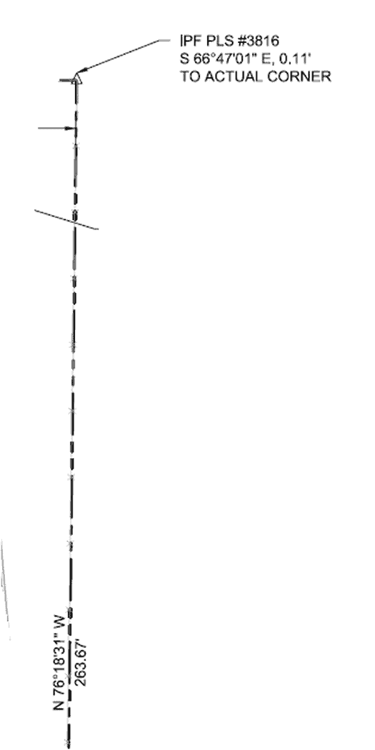 holy-cow replied 3 years, 2 months ago 27 Members · 52 Replies
- 52 Replies


Foolish dreamers.

Ha Ha…I too hate that. I just don’t understand and I never will. Deed stakers.

I believe I received that same bid package. What is worse is that the perpetrator will likely win the re-cert.
I am fairly certain that is not common practice in that part of KY, also.

Is this a regional thing? I have seen this in areas outside of where I normally practice. I have also seen monuments described as “1” IPF, 0.07′ north, 0.11′ west of corner”.
Gregg
Is this a regional thing? I have seen this in areas outside of where I normally practice. I have also seen monuments described as “1” IPF, 0.07′ north, 0.11′ west of corner”.
Gregg

Used to be required on Mass Land Court plans. Probably why this happens on a lot of Mass plans

We get this. The correct way to state this would be “my touchscreen places a theoretical meaningless math point 0.17 from the true exact legal perfect property corner. Be impressed with my buttonpushing”.

We really don’t have rocks or anything, here in Houston. 1:2400 is likely an easy measurement, but I would guess setting a 1″IP in rocks is a little harder.

Well,if its wrong, it’s wrong. 0.01′ or 10′ doesn’t matter.
He shoulda just moved it over.
(Just kidding)
N

We had a young guy that use to do that. I had coffee with him one day and asked him what that meant. Was his survey off that much or was it the monument that was off and what was that based off of. He quit doing after that meeting.

Nicely handled. Mentorship ???

It should read from the actual cor to the rejected monument. With an explanation as to why it was rejected. So I could read the explanation!
Ha ha ha

What I like about it is 66d47’01”, 0.11′, they actually typed out 01″ as if that has any meaning in 0.11′. I’m not going to calculate what 01″ is in 0.11′ but I know it isn’t much.

I saw a note, I think I posted it before, that said they found a dimple in a brass, plat, centerline monument, and they missed it by 0.01′! They even noted the bearing! To the second! Calc that one Moe, I’ll bet it’s even less…
I hope everyone has a great day; I know I will!
This is actually the “right” answer.
Common practice dictates a lot of what we see and probably 99% of what we disagree with or find strange on other’s maps is due to common practice in their area. Even in adjoining counties in the same state you can see themes. This has to do with who mentored who, who the best surveyor was in the area, etc.
-All thoughts my own, except my typos and when I am wrong.So, if you hate something…show us your resulting map…how did YOU do it. Sure, show the one you don’t like…but we are here to learn. Show me how you do it. Show me what you think and have learned is the correct way. I want to know.
I recently moved to a different county, and one of the best surveyors here through the 70’s and 80’s recorded all sorts of surveys. (Call him Surveyor A.) He has all sorts of records and he broke down most every section in the county.
Out front of my office is a quarter corner monument set by Surveyor B. Surveyor A rejected the location by about half a foot. The local surveyors I talk to all acknowledge that the quarter corner is likely off…they assume that Surveyor A was right, since he ALWAYS did very good field work. They also acknowledge that at this point 50 years later most will simply hold the monument.
Every surveyor in the county relies on Surveyor A’s public records. They all know he was a good surveyor. And when said monument was rejected, it was pretty new. But here we are 50 years later…and there are two positions for that quarter corner. I wish that if he felt that strongly that he would have moved the monument. Thing is, I think he respected Surveyor B too much to do that…think about that for a bit.
I would submit that the issue is not the surveyor. It is a regulatory issue. Not a continuing education issue, but an issue contained in the regulations and codes of many states. Washington law essentially creates the issue above.
in 1975 or whenever the above occurred, how could Surveyor A accept a recently set monument that was off by 0.5′ when the surrounding original monuments were still in existence? Would he really be safe from censure by simply pointing to the other guy? What if the difference cost someone money, who would be liable?
The issue is always the second surveyor. The first, subdividing surveyor and their marks have a clearly defined place in law. The second surveyor, the one that follows…their marks have a different standing.
BTW my interpretation of the “0.10 N” call is not arrogance. Instead, I read that as a statement of humility. “Found this and the found monument might be correct. It misses my measurement by 0.1, which information I offer in case you follow me and also miss by the same…it will let you know you are in my footsteps.”
And…I also acknowledge that if you are calling it off, perhaps (if we looked at this from the land owner’s perspective) we should only call it as a miss if we are willing to pull the monument out and reset our own. In essence, that is what we are doing in the record…creating a question as to the real location of the corner. That is the exact opposite of what the owners expect.
The “correct” way of showing the true location of the corner while also demonstrating our field work with our observer field measurements can be accomplished in many ways.
One of the reasons I like Gary Kent’s workshops is that he takes his actual surveys and puts them up on the wall. They form the basis of teaching and discussion. His self-deprecation helps put things in perspective, while giving real world examples of how he approached an issue.
I have walked out of more than one presentation that involved a out of town surveyor railing about this and that practice without ever presenting their own work for review. Their self-righteousness IS the proof and the logic.
So, if you hate something…show us your resulting map…How did YOU do it? Sure, show the one you don’t like…but we are here to learn. Show me how you do it. Show me what you think and have learned is the correct way. I want to know.
-All thoughts my own, except my typos and when I am wrong.Show record dimensions. Show your dimensions. Same monument. Same physical points. The end. It’s what I do.
Sometimes, if things are within some tolerance, I use record b/d.
Question @dmyhill when you set corners, where you’ve got a target coordinate, and a final set “where it landed”, which coord value do you publish?
Where it was supposed to be set, say at mid point, or pro-rated point, or where you actually set it?
🙂
Nate
Log in to reply.