
Activity Feed › Discussion Forums › Education & Training › Double Proportion Problem

@aliquot This is a test problem and is not intended to get down to the nitty-gritty of a true situation and is for the the test taker to solve to prove that they have the knowledge to derive an answer.
The north-south lines on an old GLO plat and were often left blank and were meant to be a North-South bearing. The East-West lines mostly were a different matter though.

I would submit that “it depends” on when the original survey was performed. Out here in the Great Basin, GLO Surveys done prior to the issuance of the 1890 Manual “required” the North/South (meridianal) Lines between all interior Sections to be run “True North,” and as Charles stated, no bearing was shown on the North/South Lines (usually the Magnetic Variation IS though.
The language in the 1890 Manual concerning this issue is a little vague (but it’s there), and the 1894 Manual clearly states “parallel to the range line.”
Loyal

You are right often they are, but often they were not too. This isn’t about the nitty gritty of a real situation. This is about not having all the information required to do part of the calculation the question is asking for. Any surveyor who just assumes the the original bearings are cardinal without checking probably shouldn’t be licensed.
By the way, there are many GLO plats out there where the bearings are blank, but they are not cardinal. That information was only shown in the notes.

@dave-karoly Thanks for providing the math. I was able to check my work and I got it now. I wasn’t doing it two step.
@charles-l-dowdell Thanks for taking the time to put this together. It’s very helpful for me to visualize these questions.

This is not meant to be dismissive of Messrs. Olson and Aliquot’s excellent answers, BUT….
While it can be fun to pick apart bad exam questions, that is not very helpful to slim. I despise multiple-guess exams as a fitting way to evaluate competency prior to licensing. It doesn’t matter who writes the questions, whether that be the NCEES, state licensing boards, BLM for the CFedS exam, etc. there will always be bad questions on exams.
stlsurveyor gave good advice.
Posted by: @stlsurveyorThose questions were written by Dr. Elgin and that is exactly how the MO, AR and KS State Specific Exam is written. When we were all studying for the tests years ago we called it “Dick Trickery”.
When studying for these tests always slow down and read them all twice – devil is in the details, usually multiple steps to get to final. This process tests not only math but the fundamentals of correct process.
Every exam taker’s goal is to pass the exam. Period. You won’t get credit for complaining about a bad question that you left blank.
Out of the four answers, Answer A is the best one. It is the only answer that employs double proportion (followed by single proportion to compute the position of the N 1/4 corner). Yep, one has to make some assumptions, such as the record bearings of the north-south line are due north with reocord distances of 80 and 40 chains, and that the true bearings returned in the original survey of the east-west lines are sufficiently close to cardinal to not impact the solution.
Answer B is incorrect because instead of computing the position of the lost section corner by double proportion, it places the section corner at the intersection of the lines between the four found corners and then single proportion is employed using that intersection and the found NE Cor. of Sec. 16 to compute the N 1/4 corner.
Answer C is incorrect because it places the N 1/4 corner on the straight line between the NE Cor. of Sec. 16 and the N 1/4 Cor. of Sec. 17 at the proportionate distance of 2634.05 ft. from the NE Cor. of Sec. 16.
40.05 x 7872.54
(39.6 + 80.1)
Answer D is incorrect because it places the N 1/4 corner on the straight line between the NE Cor. of Sec. 16 and the N 1/4 Cor. of Sec. 17 at the record midpoint of 40.05 ch. (2643.30 ft.) from the NE Cor. of Sec. 16.
Best of luck slim in your exam. As stlsurveyor said, first figure out what computational method(s) to employ, then make “appropriate” assumptions if the question fails to supply full information and solve. Again, I detest multiple-guess exams as a “measure” of competence, but the NCEES implemented that exam type a couple of years before I took the exams in 1984. The psychometricians have all sorts of numbers to demonstrate that the current exams are good, objective-based measures of technical competence. To this old gray beard, there is no comparison between a real world survey problem and an exam multiple-guess question. However, you have to pass the slapdash exam before you get to solve real problems.
???? /end rant
You won’t find many questions this bad on the NCEES exam. If a question like this did make it on the PS exam it would be excluded from the scoring. Professional test writers don’t leave out something as crucial as this.
In the real world, assuming the bearings are cardinal without checking is the kind of thing that can ruin a career.
The best way a question like this could test a surveyors ability is by testing to see if they notice something is missing. There are questions like this on exams like the PS, but there would be another option, “Not enough information is provided to answer th question”.
There is at least one other screwed up answer on this test. It can be eliminated by good test taking skills, but dealing with a test writers mistakes is no way to prepare for the real exam.

All this focus on numbers and calculations and I’ve never once double proportioned a section corner in real life. I’ve done a few single proportions. There’s almost always something better available.
We definitely approach slim’s question from different perspectives. Your posts are mainly concerned with eliminating “bad” questions from an exam. I have a pragmatic viewpoint, so I’m mostly concerned about how best to answer a “bad” question and move to the next question.
The only times I’ve computed lost PLSS corner positions were to answer questions on the SIT and LS exams in 1984 and the CFedS exam in 2011. Perhaps one day I’ll need to compute a lost PLSS corner when tasked with setting corners to a placer mining claim patented by legal subdivisions. The only other time I would consider using double proportion would be to reestablish interior corners to a block of lode mining claims as suggested by John V. Meldrum in his 1980, “Mineral Survey Procedures Guide.”
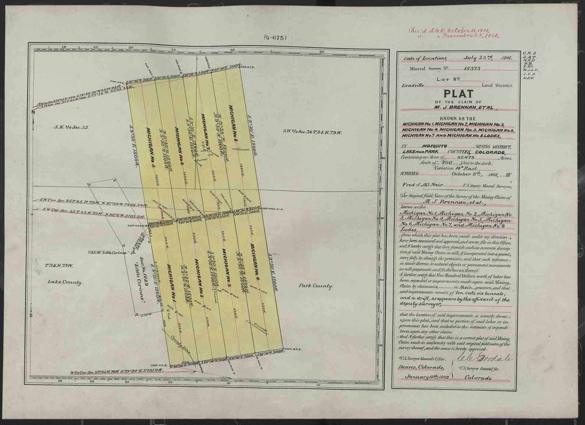
Below is the plat of Sur. No. 15373. if one or more interior corners were lost, I might employ double proportion to reestablish them (if it gave a good result that was not at odds with keeping the end lines substantially parallel). This mineral survey was conducted in 1901. If it had been conducted after September 1904, I’d carefully read the “Report” section of the field notes to see if the mineral surveyor described which lines were run on the ground before deciding which method to employ.
Before computing the lost interior corners by double proportion, I’d simplify the computation of cardinal equivalents by rotating the found corners clockwise by 9?ø30′

When taking tests such as the FS or PS it’s helpful to remember that you’re trying to find the best answer not the right answer. A subtle but important distinction.
- Posted by: @dave-karoly
All this focus on numbers and calculations and I’ve never once double proportioned a section corner in real life. I’ve done a few single proportions. There’s almost always something better available.
It really depends on where you are working. Double proportioning is often the only resort when you are surveying in an area where most boundary lines are not occupied to. For example, it would be rare someplace like Oklahoma, but much more common in some parts of Alaska where fences, farming, roads and landscaping are unheard of.
Figuring out how to best answer a bad question and moving on is the right approach to test taking, and there will be “bad” questions on the NCEES exam so that is good strategy to learn. This question however, is fundamentally flawed. A crucial step in performing the calculation by the “BLM method” is missing. It was especially concerning to me, because this is the kind of mistake I see in the field often, sometimes with disastrous consequences. There would be no justification to assume a cardinal record in real life.
I don’t know if double proportioning would ever be appropriate on a mineral survey. The only reason double proportioning makes sense, is the unique way townships were subdivided. If they were done “by the book” each internal section corner had 4 independent measurements made from them with four semi independent determinations of bearings made. The two east west lines would have had two independent corrections for curvature. When there is substantial evidence that the “book method” wasn’t used, double proportioning shouldn’t be used.
If the standard methods (grant boundary, compass rule, parallel end lines, single proportioning, ect) used in mineral surveys fail, I would look at the method of miscellaneous control before resorting to double proportioning.
 Posted by: @aliquot
Guys this question is screwed up, you are all assuming the original record is cardinal. The original berings are not provided, so it can’t be solved.
The assumption that the north south bearing is cardinal is an especially bad assumption. Even if we assumed this township was perfect, this section line would not be cardinal.
The assumption needed is that the lines have the same bearings. There is no need to assume they are cardinal.
.
Lots of fun and games. How about a test question on recognition of retracement evidence rather than an exercise in theory? People like Slim get the notion that because it was tested and taught then by God it must be practiced.
- Posted by: @bill93Posted by: @aliquot
Guys this question is screwed up, you are all assuming the original record is cardinal. The original berings are not provided, so it can’t be solved.
The assumption that the north south bearing is cardinal is an especially bad assumption. Even if we assumed this township was perfect, this section line would not be cardinal.
The assumption needed is that the lines have the same bearings. There is no need to assume they are cardinal.
Sure, but that is still an assumption that should never be made.
- Posted by: @aliquot
I don’t know if double proportioning would ever be appropriate on a mineral survey. The only reason double proportioning makes sense, is the unique way townships were subdivided. If they were done “by the book” each internal section corner had 4 independent measurements made from them with four semi independent determinations of bearings made. The two east west lines would have had two independent corrections for curvature. When there is substantial evidence that the “book method” wasn’t used, double proportioning shouldn’t be used.
If the standard methods (grant boundary, compass rule, parallel end lines, single proportioning, ect) used in mineral surveys fail, I would look at the method of miscellaneous control before resorting to double proportioning.
Your statements not to use double proportion are contrary to the guidance provided in Chapter VI of the “Mineral Survey Procedures Guide” and the “consideration” described in the “Lost Corners” section 10-213 (for a block of claims) in the 2009 Manual. I attached a PDF of Chapter VI of Meldrum’s guide that states on Page 59, second full paragraph (see also Figure 8 on page 60):
In reestablishing corners of a block of claims, the rules of proportionate measurement may be applied. In Figure 8, missing Corner No. 2 of claims E, F, G and H can be restored by double proportion. Missing Corner No. 1 of claims A and B may also be restored by double proportion; since there is no corner beyond this corner, the record distance from Corner No. 2 would have to be used in this direction.
Meldrum’s musings are of course, only guidance for how to proceed. The 2009 Manual sections on “Lost Corners” is included below.
Lost Corners
10-213. There is no hard and fast rule for reestablish??ing lost corners of lode mining claims. The method should be selected that will give the best results, bearing in mind that end lines of lode claims should remain sub??stantially parallel, if parallel by record. When the origi??nal surveys were made faithfully, the application of the principles of parallelism, record distances, record angu??lar relationships, and record relationships between the claim and the workings on it, in combination with the presumption that the original intent was to be conform??able with the statutes governing dimensions and area, should substantially meet the objectives stated above.
In restoring lost corners of irregular claims, such as nonrectangular placers or millsites, the secondary meth??ods of broken boundary adjustments (sections 7-53 and 7-54) should be considered. These may also be applied to lode claims if application of the methods described in the previous section does not give adequate results.
In restoring lost corners of a block of claims, originally surveyed at the same time, the primary methods of pro??portionate measurement should be considered. The field notes and order should be consulted to determine if the basis for record directions deviates from the general plan (section 10-121).
As with all lost or obliterated corners, the position of a corner of a mineral survey must be determined from the best available evidence and in such a configuration that will place the lines as nearly as possible in their original positions.
10-214. Caution should be exercised in the use of any ties to or from adjoining surveys when the descriptions for the conflicting claim corners, PLSS corners, or min??eral monuments are not mentioned in the field notes memorandum and may in fact have only been calculated and not surveyed on the ground. Such calculated ties, as a rule, should not be used.
The Manual only asks the surveyor to consider proportionate methods, and usually only in the case where the methods outlined in the first paragraph of Sec. 10-213 do NOT give a good result. As you know, the “primary methods of proportionate measurement” are listed in Chapter VII, those being double proportion and single proportion (and their variants). It is important to note that secondary proportionate methods should be avoided when reestablishing lost corners to lode mining claims. They are generally only appropriate for irregular claims such as nonrectangular placers and mill sites.
Both Meldrum’s guide and Section 10-213 begin with the caveat that “there is no hard and fast rule for reestablishing lost corners of lode mining claims.”
Below is an example mineral survey conducted after September 1904 (1908) where the first line of the “Report” section of the official field notes state, “All lines of this survey were run direct or by traverses upon the ground.” I would not use proportionate methods in this case as the mineral surveyor states that all lines were not directly run.
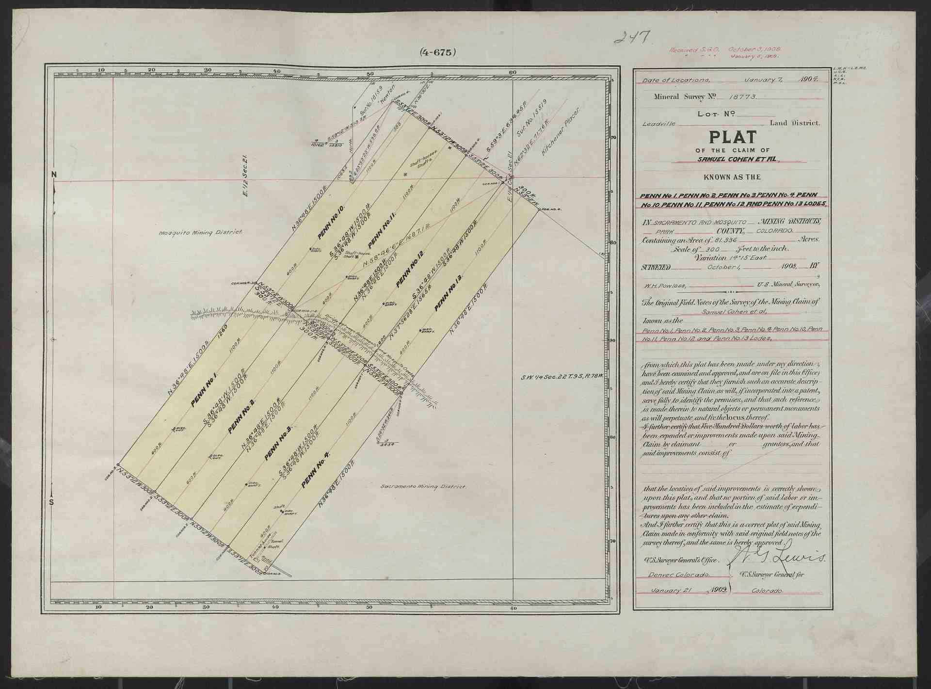
The Penn lodes are located on Pennsylvania Mountain, which is southwest of Alma, CO. The plat shows the ridge line running along the interior corners. This is a photo looking east-southeast of Pennsylvania Mountain (taken on Aug. 5, 2009). The northerly end lines would be approx. 1400 to 1500 ft. below the ridge line, which indicates why the mineral surveyor did not directly run all the lines.
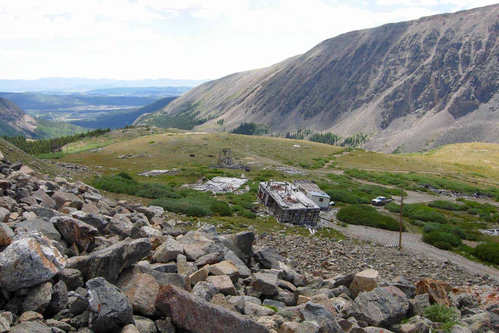
The photo was taken when Dave Karoly visited me. We are on London Mtn. looking for stones of mineral surveys that were part of the Sinnott v. Jewett land decision (33 L.D. 91). In the lower right, foreground is Cor. No. 1 of the Silver Monument Lode, Sur. No. 15714 (the stone has a flat top face that is light tan in color).
“In restoring lost corners of a block of claims, originally surveyed at the same time, the primary methods of proportionate measurement should be considered. The field notes and order should be consulted to determine if the basis for record directions deviates from the general pla (section 10-121).
As with all lost or obliterated corners, the position of a corner of a mineral survey must be determined from the best available evidence and in such a configuration that will place the lines as nearly as possible in their original positions.”
These are the key passages. The primary methods include single proportion, three point control, two point control, and index corrections. All of those are applicable (some in limited circumstances) to mineral surveys.
“The field notes and order should be consulted to determine if the basis for record directions deviates from the general plan”.
It would be very rare to find a set of field notes for a MS that supports double proportioning. For most MS corners common to four claims the notes indicate the survey was run around each claim individually. We know that is not how the surveys were usually performed, but I have never seen any evidence to support the idea that mineral survey was done according to the instructions for the PLSS (rotated). Have you?
Without either notes or other substantial evidence to support the PLSS method of surveying I certainly couldn’t defend a double proportion position as the “onfiguration that will place the lines as nearly as possible in their original positions.” For the same reason I have only used double proportioning once on a private subdivision. It was surveyed by a former GLO surveyor, the lots were cardinal squares and there was evidence of random lines on the east-west lines.
”All lines of this survey were run direct or by traverses upon the ground.”
This statment certainly rules out double proportioning, but do you think it rules out all proportioning?
“there is no hard and fast rule for reestablishing lost corners of lode mining claims”
Of course I wouldn’t never claim that not using double proportioning is a hard and fast rule, I just think the circumstances in which it is applicable are very rarely encountered.


Log in to reply.