
Activity Feed › Discussion Forums › Strictly Surveying › Colonial Land Surveying
 Posted by: Scott EllisPosted by: Cameron Watson PLS
What shape do you think the PLSS is?
I’ll answer your question with a question…what shape do you think a section is?
Hmmm maybe call it Geoid model square.
Straight lines = AKA Line of Constant Bearing = AKA Meridional boundaries that converge toward the poles and latitudinal boundaries.


I’m trying to remember the last time I encountered a square section. 32 years in 3 states and not one I can recall.
square
NOUN
1. a plane figure with four equal straight sides and four right angles.Your friendly, virtual neighborhood Webmaster Posted by: Wendell
I’m trying to remember the last time I encountered a square section. 32 years in 3 states and not one I can recall.
square
NOUN
1. a plane figure with four equal straight sides and four right angles.Yes, a square by definition…
Texas is the only state in the Union that is completely on a ‘square’ grid. Straight lines, North/South, East/West. Every other state recognizes the curvature of the earth and acts accordingly.
In PLLSia, the North/South lines converge and the East/West lines are on a curve (just ask Kieth); we have a standard parallel every 4 Townships, to correct for the convergence. This is basic surveying, in the Public Land Survey System. If you’re too ignorant to recognize that; please go back and retake surveying 101…
I hope everyone has a great day; I know I will! Posted by: RADARPosted by: Wendell
I’m trying to remember the last time I encountered a square section. 32 years in 3 states and not one I can recall.
square
NOUN
1. a plane figure with four equal straight sides and four right angles.Yes, a square by definition…
Texas is the only state in the Union that is completely on a ‘square’ grid. Straight lines, North/South, East/West. Every other state recognizes the curvature of the earth and acts accordingly.
In PLLSia, the North/South lines converge and the East/West lines are on a curve (just ask Kieth); we have a standard parallel every 4 Townships, to correct for the convergence. This is basic surveying, in the Public Land Survey System. If you’re too ignorant to recognize that; please go back and retake surveying 101…
I disagree. A large portion of Georgia is on the “Land Lot” system where the lines run “North-South” and “East-West”. Of course there is also a portion of the Land Lot system where the lines run North 30 degrees West and North 60 degrees East. Add that to the “Headright Districts” and surveying in Georgia CAN be a mess. And then there are the FIVE different sized Land Lots, 40 acres, 160 acres, 202.5 acres, 250 acres and 490 acres. It’s all in where you survey and following the footsteps of the “original” surveyor as best you can.
Andy

Would it be safe to say that there are difficult surveys in both Colonial and PLSS? And very easy ones too? I find it hard to believe that you don’t run into problems in parts of either.
 Posted by: RADARPosted by: Wendell
I’m trying to remember the last time I encountered a square section. 32 years in 3 states and not one I can recall.
square
NOUN
1. a plane figure with four equal straight sides and four right angles.Yes, a square by definition…
Texas is the only state in the Union that is completely on a ‘square’ grid. Straight lines, North/South, East/West. Every other state recognizes the curvature of the earth and acts accordingly.
In PLLSia, the North/South lines converge and the East/West lines are on a curve (just ask Kieth); we have a standard parallel every 4 Townships, to correct for the convergence. This is basic surveying, in the Public Land Survey System. If you’re too ignorant to recognize that; please go back and retake surveying 101…
Radar,
I went back to my Elementary Surveying an Introduction to Geomatics the Eleventh Edition by Paul R. Wolf and Charle D. Ghilani, not sure if that was the book for Surveying 101 however I was wrong.
I should not have used the word square to describe the shape of the tract, rectangle is the shape for the Public Lands Survey

Aren’t they really partial surfaces of a frustum?
 Posted by: RADAR
Texas is the only state in the Union that is completely on a ‘square’ grid. Straight lines, North/South, East/West. Every other state recognizes the curvature of the earth and acts accordingly.
Not exactly accurate statement. Some Texas surveyors had the training and understanding of lines of constant bearing and would employ those practices in their work whereas others did not. You have to follow the footsteps of the original surveyor and a helpful step is learning how he practiced his profession.
- Posted by: Scott Ellis
I should not have used the word square to describe the shape of the tract, rectangle is the shape for the Public Lands Survey
I’ve never seen a rectangle section either.rec?útan?úgleNOUNA plane figure with four straight sides and four right angles, especially one with unequal adjacent sides, in contrast to a square.Your friendly, virtual neighborhood Webmaster  Posted by: foggyidea
As a former CFedDs surveyor, and 35 year colonial surveyor I agree with everything that you said. I was ‘joking’ in my post. Surveying isn’t easier anywhere. Every place is going to have it’s issues.
My post was poking fun at a predecessor from the early 1900’s that kind of described a common problem for us here on Cape Cod.
I like the note….at least he was being honest with things.
- Posted by: Scott Ellis
I do not see the difficulty in Survey something that is a square, where you have known places to look for corners, a manuel telling you how to Survey, and where everything is recorded in the courthouse, and most of the city and county laws match with what the manual tells you to do.
However based on plenty of the same questions from PLSS Surveyors on this site, that most Colonial Surveyors would never have a problem with it must be difficult.
Yea, yea, whatever…blah blah blah. Arrogance is not a virtue… where is your buddy Kent anyway?

This pointless argument resurfaces on an all too frequent cycle. The level of difficulty of my work does not vary based on the level of difficulty of surveyors working 100??s or even 1000??s of miles from me. The level of difficulty of my work is more directly impacted by the level of effort and care taken by those surveyors that walked the lines before me, past and present surveyors included.
Go get after it today gentlemen. Your own personal challenges await you.

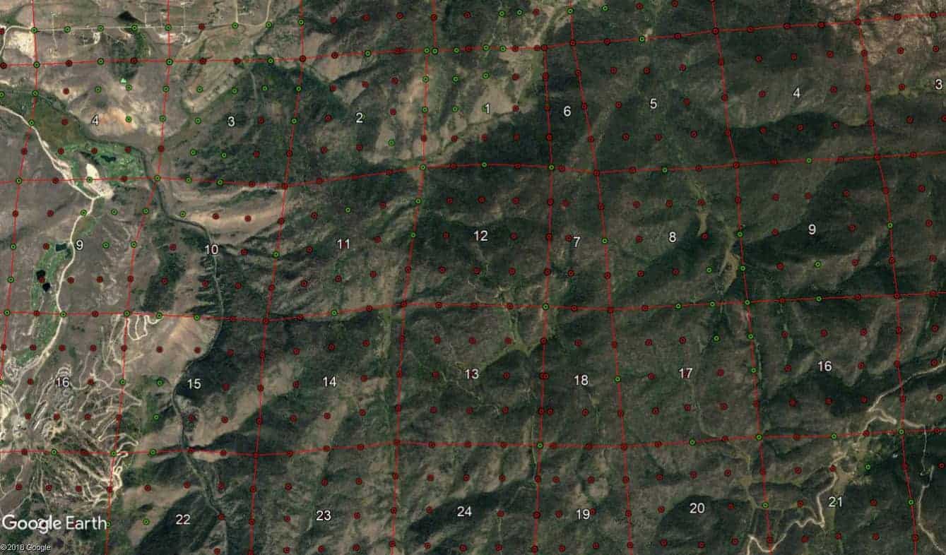
Spanish Land Grants within the PLSS.
St. Marys River in Florida a PLSS state. North Florida Surveyors as well as South Georiga Surveyors know all about these wrecks on land. Some townships have sections numbered as high as 50+ as opposed to 36. Note the section numbers.
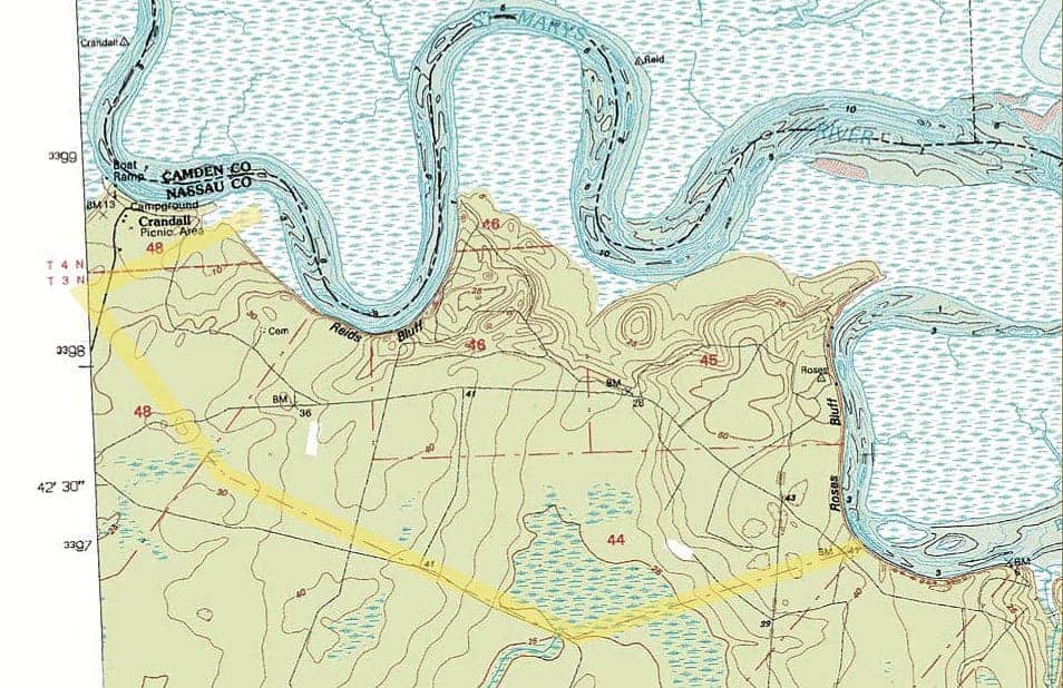
https://www.floridamemory.com/collections/spanishlandgrants/maps.php
Yea Boy we got is easy allright. ?
- Posted by: roger_LSPosted by: Scott Ellis
I do not see the difficulty in Survey something that is a square, where you have known places to look for corners, a manuel telling you how to Survey, and where everything is recorded in the courthouse, and most of the city and county laws match with what the manual tells you to do.
However based on plenty of the same questions from PLSS Surveyors on this site, that most Colonial Surveyors would never have a problem with it must be difficult.
Yea, yea, whatever…blah blah blah. Arrogance is not a virtue… where is your buddy Kent anyway?
I do not know where Kent is, I have never met him in person nor have him and I ever directly talk to each other.
I am not being arrogant. It’s a well know fact the PLSS system was designed to be an easier simple system.
Denial is the first step.
- Posted by: FL/GA PLS.
Spanish Land Grants within the PLSS.
St. Marys River in Florida a PLSS state. North Florida Surveyors as well as South Georiga Surveyors know all about these wrecks on land. Some townships have sections numbered as high as 50+ as opposed to 36. Note the section numbers.
https://www.floridamemory.com/collections/spanishlandgrants/maps.php
Yea Boy we got is easy allright. ?
In Texas we deal with Spanish Land Grant as well as Mexico and Republic and State of Texas, without the benefit of having a nice grid to work off of.
 I hope everyone has a great day; I know I will!
- Posted by: RADAR
What can you teach me, that proves PLSS is harder to Survey in than Colonial Surveying?
 Posted by: Scott EllisPosted by: RADAR
What can you teach me, that proves PLSS is harder to Survey in than Colonial Surveying?
From what I’ve read I don’t think anybody could teach you anything.
- Posted by: paden cashPosted by: Scott EllisPosted by: RADAR
What can you teach me, that proves PLSS is harder to Survey in than Colonial Surveying?
From what I’ve read I don’t think anybody could teach you anything.
Oh that’s not true I am learning how sensitive PLSS Surveyors are, and how they desperately want to be seen as equals to Colonial Surveyors, but when ask to provide examples, they never do and have to resort to name calling.
At least Gene tries and provides examples, and they do look difficult, however those are mineral surveys not Surface.
What makes you think PLSS surveyors are desperately wanting to be your equal?
 I hope everyone has a great day; I know I will!


Log in to reply.