
Activity Feed › Discussion Forums › GNSS & Geodesy › Clark 1866 ellipsoid
Clark 1866 ellipsoid
Posted by OleManRiver on March 14, 2023 at 1:58 amI have not found my old book of tables for the scale factor and such from clark 1866 ellipsoid. I can get the scale factor I believe from ngs documentation. I do have a question if someone remembers or can tell me if i am remembering correctly. At Meads Ranch where NAD27 was placed wasn??t the ellipsoid at 0 zero here between MSL and clark 1866 . I was trying to remember the maximum distance between elevation and ellipsoid max separation in CONUS. I believe the error was minimum for it as clark 1866 fit North America very well. So at meads it was ellipsoid and THE geoid were the same. Just all of the numbers blasting through my head since working in this datum recently. Man how far we have come. But some of this stuff is all foggy but somehow got to bouncing around in my head these last few days.
RADAR replied 1 year, 1 month ago 4 Members · 23 Replies- 23 Replies

The North American Datum of 1927 (NAD 27) is “The horizontal control datum for the United States that (was) defined by (a) location and azimuth on the Clarke spheroid of 1866, with origin at (the survey station) Meades Ranch.” … The geoidal height at Meades Ranch (was) assumed to be zero. “Geodetic positions on the North American Datum of 1927 were derived from the (coordinates of and an azimuth at Meades Ranch) through a readjustment of the triangulation of the entire network in which Laplace azimuths were introduced, and the Bowie method was used.” (Geodetic Glossary, pp. 57)

@jacavell thank you. I was thinking that i just couldn’t get the information to stop bouncing around in the jug that sits on my shoulders. I have about 1/4 of my books at the office and the rest in storage. I had a project recently that has to be done in nad27 and supposedly in ngvd29 vertical. After completing some observations I confirmed that it was in nad 27 but with a shift and rotation. The vertical seems to have been converted from a navd 88 height but the difference was apparently applied twice in the wrong direction. I have some more investigating to do but sitting here tonight i was going through my head Meads Ranch and all and then I was like what was the ellipsoid to elevation difference and i kept saying to myself msl or the geoid. At origin but just couldn’t make myself get that clear. I appreciate now maybe i can sleep without the old hamsters turning the wheel all night in my head. Lol.

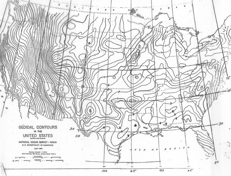
“Official” NGS NAD 27 geoid separation map. I suspect that not many outside of those of us who worked on the NAD 83 adjustment have ever seen this.
@base9geodesy yes thats a great one. I am so glad I checked my values before depending on commercial software alone. Now that i have everything figured out. When i went through DMA we did get a book on the clark 1866 scale factors and a history of it in the CONUS. I just have that sucker packed away somewhere. You might not but some might be surprised at how many people do not realize that the lat and long of nad 27 and nad 83 are not equal on a particular point. Had many tell me just use the lat long and no worries they are all the same. I tell them between 10 and 90 ish meters on the ground and am told i am crazy. Between the lat and long of nad 27 and nad 83. I sure cannot wait until the new datum arises as that might stop a lot of foolishness. This project i am working on had nad 83 spc scaled coordinates scaled not distances to ground. Then computed the scaled nad 83 scaled coordinates to nad 27. Grid coordinates then scaled again in attempt to take those to ground again. And i am stuck holding those values with a vertical datum that is not what was intended. And now i have to help the boss write a cover his rump note. And i am terrible at writing.
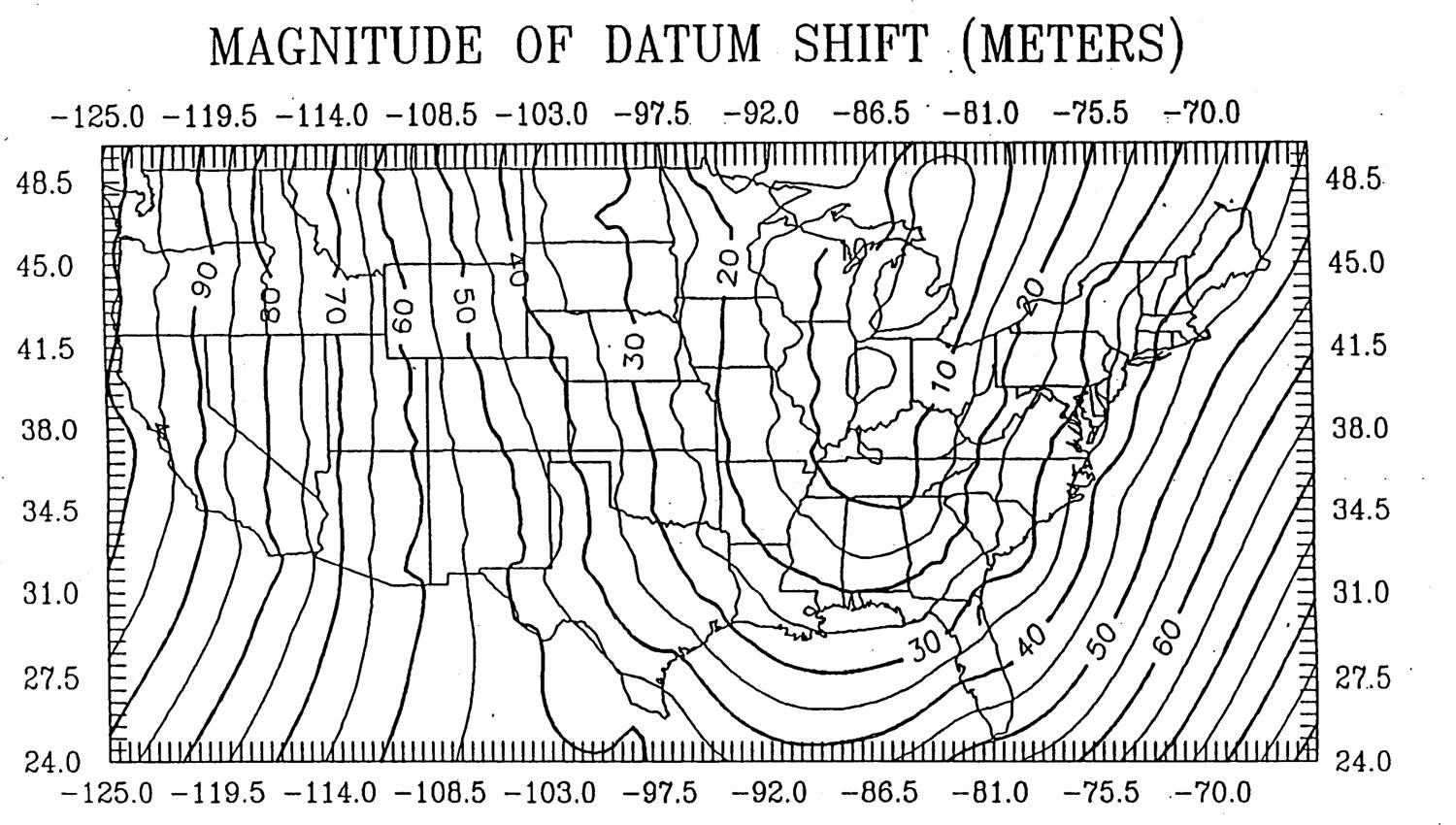
Map of CONUS positional shifts NAD 27 to NAD 83. 100 m on the west coast more than that in Alaksa and 400 m in Hawaii although that was a different datum (Old Hawaiian Datum). If you’re looking for the publication on NAD 27 SPCs just let me know what state you’re dealing with and I can link the USC&GS Special Publication Projection Tables. You can also get the NAD 27 scale factors by using the NGS Coordinate and Transformation Tool – NCAT
I do regret that there are far too many users of projected coordinates (SPCS & UTM) who do not understand that they are rigorously related to lat and long – if you can one you change the other.
I do regret that there are far too many users of projected coordinates (SPCS & UTM) who do not understand that they are rigorously related to lat and long…
Amen
@base9geodesy yes I downloaded them. Send to my wife i will preserve them . At corbin Virginia. Now you probably know who i am. Can’t wait to see you again soon. The weather is getting right for a nice bonfire and cold brew. Ncat is a nice little tool. I use it often at a minimum of spot check. How I discovered that TBC had a issue with its coordinates system manager. Finally got that resolved as well. It (TBC) had a 3 ft shift in easting only at my particular site. Once updated matches ncat within the error ellipse ncat stated. I am when i get time try the beta version of opus on my rtk vectors as a way to do some playing and have a workflow as a check. They have some very good tools available at NGS.
A night by the fire at Corbin and a wee dram of something stimulating with great friends is a wonderful way to spend some time. We’d love to do that again. We certainly miss the great group there.
@jacavell That is what is the issue is not understanding when coordinates are not just coordinates and are projected from the ellipsoid to a mapping projection. Not a full understanding of mapping distortions and other issues. I don’t know how many times i have had to take nad 83 2011 hz datum and use ngvd 29 datum for vertical and i cringe. If i were king for a day i would make a law that stated if you scale spc then you must create a new false northing or easting so it cannot be confused with state plane. And you would need to place all meta data on how and what one did. Sometimes I believe having a datum and creating a LDP would solve everything gis folks could use it surveyors would be happy as they could assume whatever just tie it to the national datum and orient it off standards .
I have a long ways to go in learning and having fun the whole way through.
@jacavell I believe it’s not lack of intelligence Most Land Surveyors are very smart. I think its a not taking the time to see truly how simple it is to just do it right the first time. Especially in today’s world. But we have become so coordinate dependent that we have failed to understand the situation. Reduce our ground distances to MSL/ now ellipsoid project to the mapping plane we can now compute and get correct grid coordinates . Notice i did not scale coordinates. Yes we can do that sometimes for projects but once we scale to ground we are no longer state plane. And should not make them look like them. We can still hold the same bearing and if done correctly hold and know the true lat long ellipsoid height to the correct datum even use the same Lambert or transverse mercator and create a new grid system that we can relate and transform to any system. But we have to state that information for someone to follow. Meta data is a must. When we move to new datum and a new version of feet for a lot of us. What happens to those in the future that follow us when surveyors do not even state usft vs international foot now. Leaving a lot of assumptions open for interpretation for sure.
A night by the fire [anywhere] and a wee dram of something stimulating with great friends is a wonderful way to spend some time…
Indeed!
I’ve questioned but never addressed a couple of things I’ve seen in TBC, the transformation parameters between NAD83 & WGS84, and the difference between Global and Local coordinates. The latter is easier to explain, just never explored.
I sympathize. gain some hope from the fact that the SPC are usually defined by statutory law and how/when they are used.
Sometimes, legal liabilities can be a strong deterrent (and an education).

I sure cannot wait until the new datum arises as that might stop a lot of foolishness
You’re kidding; right?
I hope everyone has a great day; I know I will!Tony’s heard my rant on these topics before. What we have are an array of “professionals” who are required to learn the fundamental issues of boundary law in their state(s), yet many of them have embraced geodetic positioning tools without even the most modest understanding of the foundational issues in how horizontal/geometric/vertical datums are created and managed and how coordinates can be manipulated. — “Why doesn’t My Centimeter Match Your Centimeter”
Have still have a way to go to bring the great community of surveyors up to the level they should be on these topics.
@jacavell well things are changing but most people are never in wgs84 for survey grade no matter what they say historically. I remember hearing well close enough in past. Yes tbc is. Great tool i love it but like any commercial software some things were not accounted for. If i were not such a checker i would have accepted the nad 83 2011 to nad 27 and it wouhave worked on the ground relatively well. But when my boss said we are contracted to be on nad 27 i did the ncat checks. Always have before ncat nadcon corpscon vertcon etc. I like to always go back to whoever is the caretaker of the datum to do a check. Especially since i am relatively new back in private sector. I learned a lot working at NGA and Lso dealing with vendors. And checking the list twice like Santa clause is a must.
@dougie surely surveyors will not be bad word. This stuff will they.
I can’t use with today’s tools data collector and software and office software why its so frowned upon to use a robot or other total station and just work on grid. Even if on grid one can easily produce acreage and ground distances for plats etc. we still have a mindset that gps is grid and robot is ground and mixing is bad so we make some hybrid system that works between the two and then we give that information to a county and raise a stink that gis folks are rubber sheeting. If we gave them true datum coordinates and the metadata the. We could extract that back for future use. I am not a pro just coordinate surveyor either. Trying to figure out whether a plat that has a north arrow stating grid north datum x spc. Xxx. Is ground distance or grid distance when no other piece of information is available is not wise. I re traced one recently that had placed coordinates on some of the corners. Evidently they were scaled after I surveyed the parcel as my bearings matched within reasonable amount and my computed ground distances matched between monuments. The coordinates out of the gate were feet off. Not from themselves but known datum. As i had checked into ngs monuments and published control on airport all within the size of a dime. No where on the plat was a scale factor used and where from. I did some reverse engineering and probably had a good guess it was a one point cf for entire survey. Location had been given with cf that was used i could have computed exactly where the corner was and saved a little time. So i just field computed by bearing and distance as I checked as i surveyed. I stayed in grid used the ground distance and grid bearings and followed very closely. All the pipes were found I needed for what i was doing. Truthfully I didn’t need any coordinates but if you are going to give them the. Give them correctly please. Lol.
Seems to me you are doing what you can to interpret what others have done and how to make it not so hard for those who follow in your footsteps.
Licensed surveyors are usually at the end of the line when after something goes wrong and the finger-pointing begins. There is no one else to point at.
When we realize the value we bring to projects and charge for that instead of for hours like laborers.
There is a cute aphorism that goes something like
“You don’t pay me for the 5 minutes I spent to do it, you have to pay me for the 10 years I spent learning how to do it in 5 minutes”
Besides “getting it right” we are liable to defend ourselves against even imagines torts.
Everyone likes to criticize the surveyor but they need him to be there to take the blame.
@jacavell so true. I am working towards that goal. I probably should have been already licensed years ago. But after 7 plus years in private sector I joined the USMC became a geodetic surveyor and studied and produced cartography and remote sensing and multi etc gis and such. When i got out I wanted to find a good surveyor to be mentored by and get back in the game. So I started by being a trainer for Trimble dealer to learn who was who. But life is life and I ended up building a vrs network and teaching many surveyors the pros n cons of rtk gps grid vs ground etc and personal things happened about the time the economy crashed so I went to work as an orbital analyst and worked my way up to a title of orbital scientist. Which is just a title. I learned a lot but still am no where near i would like to be. Few years back the wife asked why i just didn’t go back to land surveying and run my farm. I was tired of the suit and tie and 24/7 shift of the gps constellation and had come to a point that I realized i just flat out missed boundary surveying. So i made a few phone calls. Base9 helped point me to a surveyor who i worked part time for and got my feet back under me. Set for the first national exam last year and getting ready for the next one and state specific one. I have a lot to learn but land surveyors do as well. I am now trying to get my drafting skills up and its a chore. And of course learning all commercial software again is totally different than software that federal agencies run. I am loving being back but get frustrated when my geodetic brain hits the Land Surveying wall of this is how we do this. When using gnss and datums. The whole projected coordinates thing blows me a way how so much of this is what and how we do this. I am like its so much easier to do it correctly than the hybrid lazy way in my opinion. Maybe its just that pressure of getting in and out to turn a dollar than to sit down and actually understand how the equipment and software can do so much more. Can you imagine if the inverse forward and backward was not 180 and the sum of interior angles did not equal n-2×180 because we had to use geodetic azimuth vs grid etc. heads would explode lol. I showed this to a up and coming young buck and he was like what. I said we work on the Land Surveying side as the interior angles of a triangle equals 180 but not in the geodetic world. He is studying for his fs now. And a sample problem was kicking him on the azimuths not matching forward and backwards. Well i am done feeding cows and checking calves. So off to shower and get ready for a dinner with the family. Always fun on this site so many knowledgeable people and we are all learning together.


Log in to reply.