
Activity Feed › Discussion Forums › Strictly Surveying › Best practise for surveying boundaries?
Best practise for surveying boundaries?
Unknown Member replied 2 years, 5 months ago 19 Members · 49 Replies
 Posted by: @mightymoe
Of course that’s why I said close to foolproof. The system that is.
The operator is a different story.
I will say that GPS systems have been the simplest instrument I’ve ever used. Surveying geodetically with T2 and distance meters was wwaaayyyy more difficult and involved than GPS surveying. The very first day I got my unit was an eye-opening experience. I was wary that I wouldn’t understand how it all worked but it was more like, OH this is so simple.
This is my perspective. The “black box” of the GNSS reduces all sorts of mistakes. But, it is also much harder to know when something went wrong, especially for us who are coming from many years of total station use, where we have a kind of sixth sense about its use.
But, with today’s robots, they are just as much of a “black box” as the GNSS, so…
-All thoughts my own, except my typos and when I am wrong. Posted by: @norman-oklahomaPosted by: @norm
I’d rather have 60 mm precision on an accurate old boundary mark than 10 mm precision on a shiny new inaccurate boundary mark.
So would I. But it isn’t too much to ask to have high precision on the correct boundary mark.
100% this. Don’t know why some people talk like this is an either/or proposition. For heaven’s sake, let’s walk and chew gum at the same time.

Not the point I wanted to make. The other day I found two boundary corners constructed of #5 rebar. They were exposed above grade about as much as they were buried leaning way out of plumb. If we are going to walk the walk and chew gum should we not only be interested in surveying precisely and accurately but also constructing monuments that are stable for more than a season? Seems like the monument should have a higher importance than the precision of the measuement used to depict it on a map.
Ok, what precision is the minimum? Where I work, it is codified. If you cannot attain that for some reason, you are asked to note the precision.
Generally, from what I can tell, throughout the years the answer to, “What is the minimum?” has correlated to that level of precision which can generally be obtained by a competent technician without undue burden (expense). If we take precision as a curve with diminishing returns, then the answer lies somewhere at the start of the steep slope.
Personally, I would rather find an original corner 1 foot from record distance than find a pincushion of unrecorded marks within 0.5′. That pincushion are people that felt that their need for precision outweighed the realities of measurement.
And that is where GNSS comes in. It is much less precise than a total station, call it an order of magnitude. But, it is also the same order of magnitude more accurate than traversing, if the distances exceed anything more than a small project. Sure, you can run it through star*net, but look at those error ellipses. Take a 30 leg traverse and tell me the 95% ellipse. (And do not pick the best, pick the worst one you accepted.) I would bet you they are about what you would get from GNSS. And, if you have not create a network with that traverse, then the error ellipses are a bit of guess work, and the error will not be randomly distributed.
This is kind of the point of why we like traverses. Everything fits locally. The closer we are to each closing point, the more accurate things are, but since they are precise to each other in the middle, it is all ok.
But let us not be deceived.
Classic application:
PLSS subdivision corners control a plat layout. We run a traverse and we use that balanced traverse to set street centerline monuments. They all fit each other to 0.01′.
Another guy locates the PLSS corners with GNSS and uses RTK to set all the centerline monuments. They all fit each other to within 0.1′ (say +/- 0.05′ on each location).
BUT…traverse guy has an error elipse of 0.15 in the center of that traverse, while RTK guy is still within 0.05′ of actual location on every shot. So which one is “right”? I prefer the total station, because in practice local precision creates a better outcome for landowners (IMHO). But, that doesn’t make me “right”, it just means it is my practice.
-All thoughts my own, except my typos and when I am wrong. Posted by: @frozennorthPosted by: @norman-oklahomaPosted by: @norm
I’d rather have 60 mm precision on an accurate old boundary mark than 10 mm precision on a shiny new inaccurate boundary mark.
So would I. But it isn’t too much to ask to have high precision on the correct boundary mark.
100% this. Don’t know why some people talk like this is an either/or proposition. For heaven’s sake, let’s walk and chew gum at the same time.
It’s because some surveyors equate precision work – and technical knowledge – to “button pushing”.
“…people will come to love their oppression, to adore the technologies that undo their capacities to think.” -Neil Postman Posted by: @norm
If we are going to walk the walk and chew gum should we not only be interested in surveying precisely and accurately but also constructing monuments that are stable for more than a season?
Sure. This is the “two-bit rebar” argument, and I agree with you. A bulldozer will destroy a concrete bound just as readily as it will a #5 rebar. I like the idea of setting offsets in a place that is safe and stable rather than dogmatically setting the actual corner in harms way. The survey using public has trouble with that. If in a non-recording state the surveyors do also.
- Posted by: @norman-oklahomaPosted by: @norm
If we are going to walk the walk and chew gum should we not only be interested in surveying precisely and accurately but also constructing monuments that are stable for more than a season?
Sure. This is the “two-bit rebar” argument, and I agree with you. A bulldozer will destroy a concrete bound just as readily as it will a #5 rebar. I like the idea of setting offsets in a place that is safe and stable rather than dogmatically setting the actual corner in harms way. The survey using public has trouble with that. If in a non-recording state the surveyors do also.
Just had a 2-bit rebar arguement.
Plat has all the corners monumented with 3/4″ iron pipes with caps. They show up on multiple surveys, including mine for about 20 years. My co-worker points out that the county will probably say we have to monument the plat corners. I remind him that they have monuments…he says, “But they aren’t MONUMENTS.” I shake my head and say we will fight that battle when it comes. Ancient bounds are near and dear to my heart, they hold a sacred place in the cadaster.
-All thoughts my own, except my typos and when I am wrong. - Posted by: @rover83
I believe those numbers, in all seriousness, about 95% of the time. As others have pointed out, GNSS is a tad more fickle than a total station, but modern receivers + good practices is perfectly reliable – good enough that I’ll put my stamp on it.
At this point, which is more likely? A sloppy backsight setup combined with a total station on maladjusted legs, or a bad fix with GNSS.
I know my opinion on that matter. (and the answer might be different for different shops)
Yes, neither is acceptable, but both happen, and both have happened in the experience of us all. Perhaps WE didn’t do it, but we know someone who did. So, the “why can’t we have both argument” is completely irrelevant. We play the odds, really. We choose that path most likely to produce a good result, but only ignorant children and politicians think that there is a such thing as a perfect measurement. We do not live in that world. We have blunders and error and imprecision and inaccuracy all around us. Mitigation, redundancy, repeatability, and check check check…this is what we live by. And all of that is why you can use either GNSS or a total station, or a right angle prism and a plumb bob with your steel tape.
-All thoughts my own, except my typos and when I am wrong. 
@fobos8 I am working on a Survey of a Section of land (square mile) in the Sierra Nevada Mountains, steep, rocky in places, forested. It is open enough to use GNSS. I would expect 4 miles of total station traversing to produce an accuracy of 30cm or so.
We use a lot of redundancy, running up to 6 receivers at once for multiple hours then processing and reviewing the data every evening. TBC flags questionable points, I use the point derivation report to disable problem vectors.
A few monuments can??t be observed directly so we set control pairs then turn angles and distances to the needed monument.
We use RTK but not alone, long static is needed in difficult areas. Hoping to use RTK to set line points for boundary signs, a fire burned it last year so there??s hope.
iIn the redwood forest on the Northern California coast, forget it, traversing is the only way.
One of the keys to RTK is to choose a base location which is as clean and WFO as possible. (Wide F?? Open)
 Posted by: @dave-karoly
@fobos8 I am working on a Survey of a Section of land (square mile) in the Sierra Nevada Mountains, steep, rocky in places, forested. It is open enough to use GNSS. I would expect 4 miles of total station traversing to produce an accuracy of 30cm or so.
We use a lot of redundancy, running up to 6 receivers at once for multiple hours then processing and reviewing the data every evening. TBC flags questionable points, I use the point derivation report to disable problem vectors.
A few monuments can??t be observed directly so we set control pairs then turn angles and distances to the needed monument.
We use RTK but not alone, long static is needed in difficult areas. Hoping to use RTK to set line points for boundary signs, a fire burned it last year so there??s hope.
iIn the redwood forest on the Northern California coast, forget it, traversing is the only way.
One of the keys to RTK is to choose a base location which is as clean and WFO as possible. (Wide F?? Open)
Sounds like a nice job, thanks for the reply.
Thanks guys, for your input. I’ve learned a hell of a lot.
Cheers, Fobos8
 Posted by: @mightymoe
If you are seeing many bad fixes or large errors in your points, you must be working in way more challenging environments than I am or my equipment is more advanced.
Using 2″ geomax zoom90 robot and geomax zenith40 receivers so not quite the latest from Lecia/Trimble but pretty close (very similar to Lecia TS15 robot and GS16 GNSS). For urban boundary work control points I’m chasing <10mm 2d repeatiblity at ideally 99% CI which is pushing RTK pretty hard I find, static different but not always practical sure to time required. Can only achieve it reliably if no trees/buildings/deep gully/reflective surfaces around, usual good practice things to avoid with GNSS. Braced pole and observations 180?ø rotated pole to mean out any pole run out. Also second fix at least 20 mins later.
Not seeing large errors like from bad initialisations in early GPS days, is either repeat GNSS shots that are 20mm different or occasionally GNSS shots both agreed within 10mm but a total station shot from good control is 20mm off. For rural work boundary it’s no problem but urban trickier as always trees on properties and buildings with shiny rooves etc. and tighter precision requirements. All work here has to be done on grid bearings coordinates and recorded so no dodgy scaling GNSS to ground or bearings that change from one side of job to the other.
- Posted by: @ashton
@lukenz I’m far from an expert. I was looking at the time series for the CORS station nearest me:
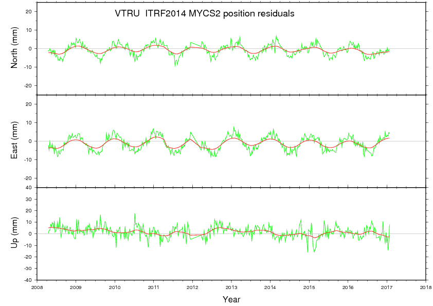
It seems the uncertainty in the position of the CORS station is comparable to the uncertainty you’re trying to achieve. How would this affect you?
Reference station positions will always vary over time due to geophysical events such as plate tectonics, glacial rebound, and ocean tides. Even the global reference frame has temporal variation which has some impact on that pattern.
That graph is the long-term series, which show the positions fluctuating in a more or less regular pattern on the order of 5mm NEU around the published position. IIRC the NGS will observe a point for a minimum of three years before being able to really position it with confidence.
Still, it’s good to realize that everything is moving, all the time, and we do need to be aware of it.
I find (and the NGS recommends) that looking at the short-term time series is more beneficial, as it shows more immediate (closer to your date of survey) positional variation as well as a better picture of how far that station is from its published position for the current realization:
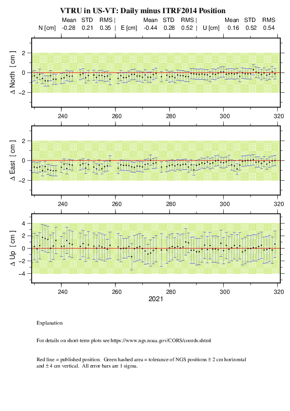
Sometimes that warrants using another station, sometimes not.
This is yet another reason why observation epoch absolutely needs to be communicated with survey metadata. In practice, we treat these stations as fixed even though they are really not, because for 99% of typical survey activities, a reference station moving 7mm (combining both N/E variations) over the course of an entire year, then back again over the next year, isn’t going to blow a job. An earthquake might though.
“…people will come to love their oppression, to adore the technologies that undo their capacities to think.” -Neil Postman 
We are in more friendly skies for GPS. The stated accuracy of our RTK units is 8mm and in my opinion that is conservative (assuming light multi-path). Often our checks are less than .02′ horizontally.
I’ve been surveying a burned out area with my older units and I didn’t run into anything my older units couldn’t handle, even under heavy canopy that wasn’t burned. One corner located near two unburned yellow pines, checked within .01′, kinda shocked me.
Every boundary corner got an original location and at least one check usually while running line, but there was never any errors to worry me, I can imagine doing it with a total station but I would have had a crew of sawyers with me like in the old days.
This was done with R8-2 units. The R10 units are even better in challenging environments. 20mm will not be surprising in deep timber, up against buildings, ect. But you have to really look for those places here, I wouldn’t probably use it around tall buildings and really heavy eastern or NW forest areas.

It is very possible that the laws/rules for determining boundaries vary from jurisdiction to jurisdiction. That said when the most dignified evidence of a boundary is the monumentation of corners, &c., the most important role of a surveyor doing a dependent survey is to locate the monuments. Then the secondary role is to measure the relative positions of the monuments so that others may use the measurement to more easily find the monuments.
Additional legal requirements in a jurisdiction may call for additional information not directly related to proving the boundary, e.g., flood risk, tax zones, &c.
Depending upon the survey and property involved, it may be judicious to “walk the lines” of the boundary to observe topo calls. I doubt a theodolite is the only means to determine the relationship between the corners. A survey with GNSS is very similar to a radial survey by theodolite, for example.
One danger is when the surveyor puts more trust in the record coordinate geometry than in the evidence of corner monuments. One then risks being labeled a button-pusher, who thinks “my measurements are better than that old stuff used in the original survey; so I will put a new mark where they should have put it originally.” That results in several things, none of them good. Property owners spend fortunes to resolve the ambiguities created by the surveyor & Surveyors can’t agree on anything – why do we need them? are two examples.
JAC
- Posted by: @mightymoe
…float with CORS.
What does that mean?
-All thoughts my own, except my typos and when I am wrong. Don’t know, find the local network RTK not anywhere near as good as your own base <1-2km from where you are working, only use the local CORS site for 0.1m work as usually 10km+ from it. That timeseries plot is only 1 sigma too, I’d be doubling at least, doesn’t seem like a very good place to have put a CORS site with that level of movement.
NZ is a skinny country running north/south with lots of ranges of hills/mountains and the NRTK base spacings don’t seem close enough to model the atmospheric changes well enough, or our communications networks have too much latency, or too much tectonic movement between bases, whatever it is results here don’t match the published studies I’ve seen for Europe/Japan/Australia
I love answering for a question to someone else 🙂 At the risk of presumption I would say floating is referring to the phenomenon that if you are seeking 10 mm or so of repeatability that in general it is not possible in an active control network without considering and applying time adjustments. Thus the end user is wise to also tie their survey to a passive control network for future reference. Even in areas where there is hardly any plate motion the CORS and as a byproduct the RTN’s occasionally update their reference station coordinates usually by more than 10 mm. When that happens obtaining precise repeatability is lost without doing time transformations.


Log in to reply.