
Activity Feed › Discussion Forums › GNSS & Geodesy › Static GPS discrepancy
Static GPS discrepancy
Posted by david-kendall on January 24, 2022 at 10:48 pmI have been getting a consistent 0.25 foot discrepancy in elevations between my total station and my static GPS for the past year. Topcon GR3 pair. They used to be very reliable and I can’t explain the error.
If I set up on one point and backsight the other point then go and set up GPS receivers and run a two hour static, the rover receiver will come in 0.25 higher than what the total station measured. The only difference between them is the rover takes a measurement every 5 seconds and the base is every 15 seconds. I’m only calling them rover and base to differentiate, the base has a sticker on it and an internal radio.
I used a loaner R10 pair recently and didn’t see the same error. I also don’t find too much slop in my traverse loops so I don’t believe the total station is the cause.
I need to run some more structured tests and see if the RTK is having the same issues but thought I would put it out there.
I know some of you guys can identify these problems by the magnitude of the error…. Thanks in advance
thebionicman replied 2 years, 1 month ago 15 Members · 22 Replies- 22 Replies

What receivers, totalstation, controller software are you using? Sounds like a measure up issue. I know in Access that it’s easy to blow this by having the wrong measure up point selected and it’s kind of buried in there. All those settings should be double checked. Just a wag.
Willy
I am not familiar with that equipment to tell which is incorrect. A level circuit between the two GPS point should agree with one of the two data sets and give you a clue on which to investigate. A collimation test of the survey instrument might also help. Collimation is spelled correctly, but this site underlines the word in red???
Historic Boundaries and Conservation Efforts
Something else to check is that you are using the exactly correct antenna types for each receiver. For example, phase center variations are a couple tenths different vertically between a Trimble R8-2 vs Trimble R8-4. Physically they look the same, but if you call for the wrong one when submitting to OPUS you enter survey hell…
 Posted by: @williwaw
What receivers, totalstation, controller software are you using? Sounds like a measure up issue. I know in Access that it’s easy to blow this by having the wrong measure up point selected and it’s kind of buried in there. All those settings should be double checked. Just a wag.
we used fixed heights on everything but the total station. It’s all topcon gear, QS total station and FC-5000 collector.
I’m pretty confident the slop is inside the GPS receivers.
@david-kendall In my experience it’s the one thing that you discount as not being the problem that is usually the problem. Sounds like you need to isolate which setup is giving you a .25 bogus measurement and go from there. Without knowing this it’s a tail chaser.
Willy
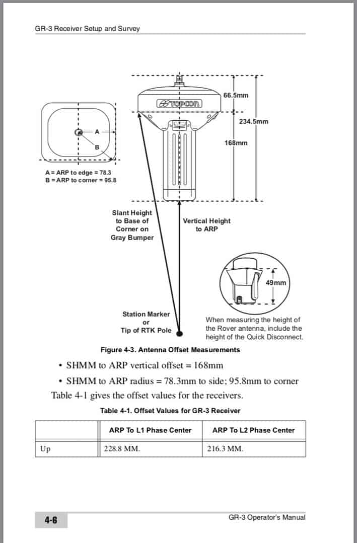
Is it being processed with an additional 170mm from the antenna bottom of mount to the slant measure point? Typically you can enter a vertical HI to the bottom of mount or a slant measure to a point on the circumference of the unit. For your model the NGS shows the vertical difference between those points as 170mm. A 70mm error on that entry would produce .23′ error. So if you were processing that slant measure with a 100mm instead of the 170mm you would get approximately the results you are seeing.
- Posted by: @lurker
Is it being processed with an additional 170mm from the antenna bottom of mount to the slant measure point? Typically you can enter a vertical HI to the bottom of mount or a slant measure to a point on the circumference of the unit. For your model the NGS shows the vertical difference between those points as 170mm. A 70mm error on that entry would produce .23′ error. So if you were processing that slant measure with a 100mm instead of the 170mm you would get approximately the results you are seeing.
This is a great suggestion. I once had the receivers default to slant measurements after a software update. …
This produced an error on the order of the one I’m getting now but I don’t believe that’s it this time, I just checked two different projects (one new and one old) and both receivers are set to vertical in the survey configuration.
The other thing I should note is that it is common for me to start the base logging static using the data collector and to start the rover using the button on the front of the receiver. In fact I almost never start the rover logging static with the data collector. I don’t believe this would affect the static log as I always input 2 into OPUS for the receiver height but I could be wrong

The fact that the deltas are the same, in the same direction, between the same two receivers of the same make/model makes me wonder if one received a firmware update the other didn’t. If they were consistent in the past then something must have changed in one of them, but not the same change, or both would still be consistent.
There’s not a spacer or something on the rover that is normally there but is taken off for static?
I can’t imagine what would cause 0.25′ of slop inside of a survey-grade GNSS receiver…
“…people will come to love their oppression, to adore the technologies that undo their capacities to think.” -Neil Postman
A friend off line suggested this:
The phase center is 80mm above the ARP (bottom of antenna); that is right about 0.25′.Not sure what he is post processing it in, but in some packages you have to specify ARP or phase center…
This most likely is a height error either in the field or office software on the GNSS end.

to be up front, I am not 100 percent familiar with topcon base/rover setups , but I agree with the others that it could be a measure up from point issue but in the sense that maybe a survey style was changed or updated and instead of (excuse my Trimble lingo) having your fixed height being to bottom of antenna mount, it is going to antenna phase center or center of bumper… that??s my best guess anyway without looking more into data; especially considering the rover/base combo is that much HIGHER consistently. ???ú????
 Posted by: @frozennorth
phase center variations are a couple tenths different vertically between a Trimble R8-2 vs Trimble R8-4. Physically they look the same
Why the hell would a manufacturer do this sort of thing to us? I get that you should read about and understand your equipment, but I’d bet that some bigger companies might have both of these models, and the guys taking them out in the field mightn’t know the difference
- Posted by: @jphPosted by: @frozennorth
phase center variations are a couple tenths different vertically between a Trimble R8-2 vs Trimble R8-4. Physically they look the same
Why the hell would a manufacturer do this sort of thing to us? I get that you should read about and understand your equipment, but I’d bet that some bigger companies might have both of these models, and the guys taking them out in the field mightn’t know the difference
Where the APC is really doesn’t concern the user, because we don’t measure to it. At least, I don’t know of a manufacturer that has an APC reference point on the receiver. The L1 and L2 APCs are different anyways, and the incoming signal(s) are usually reduced to a reference point inside the receiver that the user cannot see.
The measure up point is the bigger concern, because depending on what task we are doing, certain types of measure ups are easier/better than others.
For Trimble at least, Access knows exactly what model of receiver you are using when you connect to it, and will prompt you to modify your survey style accordingly.
“…people will come to love their oppression, to adore the technologies that undo their capacities to think.” -Neil Postman 
Take a pocket tape and measure your 2 meter pole and make sure it??s really 2.00 meters?
This was something we caught with static observations. Yes, we always measure to the antenna reference point (ARP), but if you specify the wrong antenna type (R8-4 vs R8-2), the difference from the ARP to the APC is substantially different; therefore you get bad vertical results.
Email correspondence with NGS and a close look at their antenna calibration results confirmed this.
 Posted by: @williwaw
Sounds like you need to isolate which setup is giving you a .25 bogus measurement and go from there. Without knowing this it’s a tail chaser.
Willi is right.
suggest:set both receivers up level on a board fence. Get a carpenters level to do it. Let em cook. Then swap receivers. Then opus both observations.
you will learn some things too.
n Posted by: @nate-the-surveyor
set both receivers up level on a board fence. Get a carpenters level to do it. Let em cook. Then swap receivers. Then opus both observations.
Or…find a known point, and see which one is off by 0.25′
-All thoughts my own, except my typos and when I am wrong.

Log in to reply.