
Activity Feed › Discussion Forums › Business, Finance & Legal › How Temporary is “Temporary”?
How Temporary is “Temporary”?
Posted by jhframe on October 2, 2020 at 2:37 am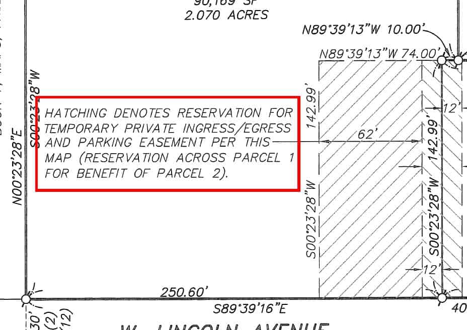
There’s no language on the map indicating an expiration date, nor any reference to a recorded document that might include same.
mike-marks replied 3 years, 6 months ago 13 Members · 21 Replies- 21 Replies


A good one for the l*wyers to argue over, not surveyors. Very poor practice to grant that one.
Perhaps if the easement wasn’t used for some period of time, evidencing that it was no longer needed, so the temporary period had elapsed, it could be ruled as extinguished? As opposed to a utility easement that may continue unused for possible future use.
.
The Attorneys involved will be able to buy that new jet they??ve always wanted. ????

Bad practice, but you will generally find the consensus is that either there were specific circumstances at the time of platting that required the easement, which means the easement expires when the conditions change, or that it expires after abandonment. Of course the trial courts are unpredictable, so your mileage may vary if it goes to court.
This looks like a modern plat. There are a lot of us that are not the sharpest pencils in the box.

State of Minnesota 505.021 sub. 7, says, “Temporary easements, building setback information, and building floor elevations shall not be shown on a plat”.
Learned that while studying. I think it is a great thing.

Hopefully there is a separate recorded document creating the reservation. More than once I’ve seen surveyors neglect to include that information on maps…

There is a need to look at the conditions on the ground, both now and at the time of platting. If Parcel 2 now has an alternative access that did not exist at the time of platting that would be a strong argument that “temporary” has run it’s course.

Is this a subdivision plat or a survey?
If this is only a survey and not a subdivision, without a separate document creating an express easement, there is a good chance the easement was never created.

Subdivision. A Parcel Map, in California parlance (4 lots or fewer). Done in 2006 by a usually reputable engineering/surveying firm.

@brian-allen
I agree, depending on the state, the plan just maps it out, but doesn’t create anything till papers are passed.

Without a related, recorded document providing the details to the whole world, it never happened………….here. Your mileage may vary.
In CA a filed Parcel Map imparts constructive notice, same as a recorded document. (Not so for a Record of Survey.)
 Posted by: @jim-frame
In CA a filed Parcel Map imparts constructive notice, same as a recorded document. (Not so for a Record of Survey.)
It’s because an ROS cannot subdivide, it’s merely a Record of existing conditions, although profound because an LS attests to it. Required in many non-subdividing transactions, most notably Lot Line Adjustments, and when there’s a discrepancy with the record and/or new monuments are set in substantially different location(s) although I’d argue Corner Records suffice if there’s no substantial discrepancies.
Sorry to thread drift but concerning the wacky world of LLA’s in Cali’ this court cite is worth 20 minutes of your time. In the late ’80s I did a simultaneous LLA involving 30 parcels to convert an equestrian subdivision into McMansion lots which were more lucrative. Same # of parcels, bigger and the surrounding equestrian (horse trail) lot was reduced to a 5′ strip. The County was aghast but had no defense. Now that the 4 lot rule is in effect it can’t be done without dozens of sequential LLSs which would take years.
That is true. But, until Jim’s clarifying post this morning, it might have simply been drawn on a standard survey. On a standard survey it means nothing. It is similar to a proposed easement. We can show one on our survey plat but it means nothing without a recorded document actually creating it.
- Posted by: @mike-marks
Required in many non-subdividing transactions, most notably Lot Line Adjustments
Note that a ROS isn’t required for an LLA per Government Code ??66412, though under some circumstances a ROS will be required under the provisions of ??8762 of the B&P Code when doing an LLA. In other words, it depends. Most of the LLAs for which I’ve prepared documents haven’t involved a ROS.

A Record of Survey doesn’t impart constructive notice because they aren’t indexed under the owner names so they aren’t discoverable in a normal search of the grantor/grantee indexes. The exception is the backdoor of being referenced in an instrument which is indexed.
They may still put an owner under actual or inquiry notice.
- Posted by: @jim-frameNote that a ROS isn’t required for an LLA per Government Code ??66412, though under some circumstances a ROS will be required under the provisions of ??8762 of the B&P Code when doing an LLA. In other words, it depends. Most of the LLAs for which I’ve prepared documents haven’t involved a ROS.
Agreed. But back in the eighties when I was doing lots of LLAs ????, mostly recorded subdivison fixes to increase marketability of the lots, some cities/Counties were swinging their weight around and requiring them, ’till the AG said no in 1994 (Opinion 94-518). Subsequently;
“A record of survey is required of any field survey relating to land boundaries or property lines whenever the survey discloses any of the following:
[ . . . ]
4. The points or lines set during a survey of any parcel described in any deed or other instrument of
title recorded in the County Recorder??s Office and not shown on any subdivision map, official map, or
record of survey. This includes new lines created by lot line adjustments that are monumented or are
established during the course of a field survey.” (CEAC 2009)performing a field survey/setting monument(s) for LLAs *does* trigger an ROS. The implication is LLAs can (should?) be a purely documentary process with no memorialization of the new lines set in the field. Back then we always set new monuments so the local agencies did have a point concerning requiring ROSs.
I understand the rationale; LLAs are tailored to require no need for fieldwork and provide an inexpensive solution for owner(s) to tweak their holdings, which is an eyebrow raiser for me; how do the owner(s) (& future owners) know where their new boundaries are if there’s no monumentation? Of course nowadays a Title Report will reveal the Deed exchange(s); in the early days sometimes the ball got dropped and although the LLA was recorded some Deeds and subrogations weren’t. That created a royal mess, especially if mortgages and easements were involved.
I’m talking through my hat here having been retired for five years now and not having done a LLA for over 25 years. I appreciate your comments and maybe I should STFU and let you young bucks take the lead. So I’m curious, do you do LLA documentation and not set monuments delineating the new lot lines?

@stlsurveyor I would think that could cause problems also. I’ve drawn a lot of plans for the construction and widening of roads. A lot of the right of way acquisition also included temporary construction easements. If the property were sold before any construction began and was surveyed I would believe that the surveyor would be negligent if he DIDN’T show it. We had projects that were put on the shelf for years before construction began.
Andy
One also needs to keep in mind that just because easements and certain right-of-way locations may appear on a set of plans that does not prove that was the final location of any of them. It is true that plan sheets should be revised and revised until there is a final set following completion of the project. That does not always happen and, even if it does happen, that does not assure that the set of plans you have in your hands or on your screen are, in fact, that absolute final set.
In one case I had a set of plans showing a total right-of-way of 60 feet, being 30 feet either side of the section line. The pre-existing right-of-way had been 50 feet. There is absolutely no documentation anywhere, including at the DOT, to prove that extra five feet on either side ever happened. This ended up being critical in a court case where a company installing a fiber optic line sliced through natural gas line at a point more than 25 feet from the section line but less than 30 feet.
In a different case of a highway passing through a small city the acquisition of the additional right-of-way involved many little slices/wedges/etc. out of existing lots in blocks. The highway plans show a uniform width from project center line which wanders inside and outside of the actual right-of-way descriptions. This has left odd little spaces of no man’s land between the actual roadbed and the improvements on individual privately-owned lots.
- Posted by: @mike-marks
So I’m curious, do you do LLA documentation and not set monuments delineating the new lot lines?
I don’t do that many, maybe half a dozen or so in the last 10 years. I can only think of one in recent times on which I set monuments, and it was unusual: a 30-year-old Parcel Map that subdivided a 100-year-old lot in which the subdividing surveyor did a decent job of establishing the old lot lines. But — near as I can tell, anyway — when his field crew returned to monument the new lots they took off of a backsight (likely an old stone monument about 1700′ from the lot) with a bearing/azimuth 10 minutes off and set their capped rebars, some of them 6′ away from the 100-year-old boundary fence. (You’d think that would have generated some head-scratching on the part of the crew, but apparently it didn’t register.) The rebars were used by the new lot owners to build fences and such, but when one of them decided to sell they found that their fence dimensions didn’t fit the map dimensions, and pretty soon the whole neighborhood was in a tizzy about the discrepancies. I was called in to assist, and I advised them to adjust the lot lines to fit the monuments. That also meant setting new monuments where the adjusted lot lines hit the exterior boundaries, and the whole thing was such a complicated mess that a ROS was pretty much a necessity anyway.
Other than that, I’ve usually been able to prepare LLA descriptions without conducting a boundary survey. My clients are generally happy to forego the new corner monuments, since a ROS usually adds a couple thousand (sometimes 2 or 3 times that) to the cost.
Log in to reply.