
Activity Feed › Discussion Forums › Strictly Surveying › Anyone here once used a Tellurometer?
Anyone here once used a Tellurometer?
Posted by jt50 on June 22, 2020 at 9:45 amWas browsing through ebay and came across a listing for a tellurometer. I think the brand name is Tellurometer itself and was used by succeeding companies as a generic name for the microwave distance meter.
This is the MRA3, there was another listing for the first model – MRA1
larry-scott replied 3 years, 10 months ago 25 Members · 40 Replies- 40 Replies

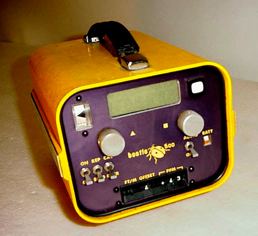
Never even heard of that device. It kinda reminded me of the old Beetle I used to haul around the countryside (sans the dish)

Those nice clean-looking units, but you’d have to be feeling really nostalgic to pay that kind of money for something with no practical use. Especially the ’59 model.

I myself have several edm units as part of my surveying instruments hoard. Most are of the geodimeter, sokkisha and keuffel brands. I don??t know why but I like the look with all the buttons and knobs.

The U.S. Coast & Geodetic Survey used them for coastline surveys:
https://celebrating200years.noaa.gov/distance_tools/tellurometermra1.html
I remember hearing some old-timers talk about them when I was living in AK (USC&G first used them in the Aleutians) but I don’t think I ever ran into anyone who personally used one.
“…people will come to love their oppression, to adore the technologies that undo their capacities to think.” -Neil Postman
I was with my father’s crew one Saturday in 1964 on the south slope of Buffalo Peaks in far western Park Co., CO. and watched a hired crew lay out C-line control with the Tellurometers for the Homestake waterline project. Pops was excited and amazed even though they were finding error in the control points he had chained/triangulated. I thought it was witchcraft.
9 years later I had my own crew with an HP3800 here in OK. Things changed in the blink of an eye back then.

in about 1970 I saw a crew using one like in the eBay links, Santa Rosa, California.
On Santa Rosa Avenue, at the Hern Avenue overpass. Yes, it was memorable.
The crew chief was friendly, he explained it a bit, but he kinda had the tone of “go away kid”.A decade later we used a more modern version of the Tellurometer when I was working under Ralph Blanchard for Polk County, Oregon… 1980 +/-
our units were much more compact, the size was more on the order of the HP 3800.
Two units were required, and both had to have an operator.They were Amazing … we were able to reach out for many miles, with very high accuracy. 20 miles or more if I recall correctly.
turning angles was not possible in daylight, much to far away to see and point to… we observed at night, turning to lights.
* A firm grasp of Geodesy and Geodetic Calculations are necessary. (modern button pushing does not cut it, Knowledge and Understanding is required)I did find one a couple years ago in my deceased cousin’s storage unit… I did not search deeper for the accessories that go with. I have too many artifacts now. Maybe I will weaken when I make another visit 😉
If someone really is interested it is probably still there, and could be had for Free.
Peter, please pick it up, before it winds up in a landfill, or getting wet in a barn, with a bad roof.
I am not old enough, to have seen one. But, I would make a guess that SOMEBODY on this site, will have a WARM place for that thing. I only read about them. I do want a Lietz Transit. The 1923 A Lietz we have, went to my brother. If I can find one, I hope to buy it.
The Lietz company was sympathetic to the Jews, in that time. Besides, ours has alot of my dried sweat on it. I stare at one of these, and the memories flood my mind…
Nate

I can’t say that I actually used one, but in the mid 70’s my Dept. Head/Crew Chief purchased a used model from whoever CalTrans was at the time. We took it to the field one day and attempted to measure a ?ñ31,000 long line. After about 6 hours we gave up. Several days later we went back with the 3800 and at the break of dawn on a very cold morning thought we could see the foresight (remember the tripl-prism?). We obtained a distance that checked with the calc’d distance from traversing within about 0.2′. The Tellurometer gathered dust in the back room and disappeared somewhere…
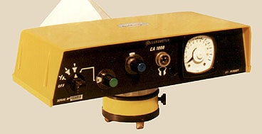
Back in 1989 I purchased a lot consisting of something like 15 of the Tellurometer CA1000 units from the Federal government on a sealed-bid sale.
Picked them up at the Federal Center in Lakewood, Colorado and brought them home.
Sorted through the units and determined which ones worked, then a friend and I took them out and occupied separate USGS and NGS points about ten miles apart. I believe we found we had six pairs of working units. We could talk back and forth over the receivers.
Sold them to an outfit based in Texas that designed microwave links all over the world. They bought them for conducting site-to-site verification of microwave communication. They planned to leave pairs in certain countries where they foresaw future business as it was simpler and less expensive than moving equipment in and out of those countries.
Someplace I think I still have the special pads used to reduce the observations.
GB

Never used a Tellurometer per se, but spent some time with the Cubic Electro-Tape DM20(s), which were similar. Great range but a bit of a PITA (HEAVY too).
Loyal

I was part of a crew using one for a week in the fall of 1979.
The engineering firm I worked for had a project to obtain cross sections for flood studies in south NJ. The boss hired a local guy to do most of the fieldwork, as we were up in Paramus, in the NE corner of the state. The local guy obtained data at all the small streams and upland sections, but needed 3 on the crew to do the soundings across the larger streams. My i-man and I were sent down south for a week. It was pretty interesting; the first and last time I ever did this.
The local guy had a boat with motor, a fathometer and a Telurometer. We set up the Telurometer at one end of the section. The receiver was mounted on the boat. The fathometer was in the boat, with the sensor hanging over the sided. We would rush to some nearby spot, usually a dock, where he had established levels earlier and get an elevation on the fathometer sensor, then rush back to the Telurometer, take a reading, and slowly back across the stream while getting readings with the fathometer. The i-man on the shore watched the distances on the Telurometer and said ‘mark’ at 50 foot intervals. On hearing mark, I’d push a button and the cross section readings were calibrated at 50 foot stations, giving the profile scale. As mentioned earlier, once could speak over the instrument, a nice feature. If it all worked the first time, we’d load up the boat and be off to the next section.
Ken
In my archives, it would be equally lost.
I will see if I can spark the interest of one of my kids, or grandkids first.
This is the reason I am not using a Kelsh Stereo Plotter for desk today (besides the bulk)

They were used in our “Advanced Surveying” class when I was in school (nearly 50 years ago). It would be set up on top of Kennesaw Mountain and the dish would be on the campus in Marietta. Don’t even ask me how it works, it just did.
Andy
They were used in our “Advanced Surveying” class when I was in school (nearly 50 years ago). It would be set up on top of Kennesaw Mountain and the dish would be on the campus in Marietta. Don’t even ask me how it works, it just did.
Andy

I have. But once. Picked off 20 mi like it was a triple reflector at a mile.
Operating the 2 units required a coordinated effort. And, the units were equipped with a headset so that you could talk to each other.
The slave unit had to be switched from one freq to another. The voice comms was as clear and quiet as a whispering in a confessional.
The hard part was that it??s very temp pressure sensitive, much more so than the ppm with an infrared laser EDM.
cool tech. Light weight!! Very long distance. With care, and repeat measurements, 10 ppm could be had, best case, with effort. But usually 20-40 ppm.

Used a Tellurometer CA-1000 sporadically when working for a County. Fantastic instrument for long distance measurements prior to the advent of GPS. Atmospherics corrections were critical, including the relative humidity, using sling psychrometers on both ends of the line. I heard the Feds sometimes flew an airplane on mountaintop 25 mile observations to collect atmospherics along the line of sight.
The coolest thing we did with it was measure from two monuments on each end of a five mile wide town for a graduate student who was studying municipal property boundary records at the courthouse. He then inversed along record boundaries (a huge task) and determined the town’s records broadly overestimated the “size” of the town, by over 500 feet.

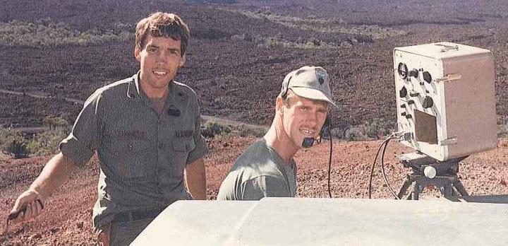
23 KM Mauna Loa to Summit Mauna Kea 1984. Carried one of these to the top of Diamond Head measuring known distances for pair calibrations. (Ok, yes the Privates carried most of the equipment, I had the clipboard…)
The green systems are very nice looking and in better shape then our systems in the 80s. Still have the cheatsheets for the Cubic DM20.

No survey, but in Feb 2002 I walked with skis I brought from Colorado to the top of the volcano, and skiied several runs. Did not see another soul. Always gloating to say I did that!
Never used one myself but read about them in ancient history books. Apparently one had to be very careful shooting over grassy fields, etc. where the transpiration would cause a phenomenon known as “ground swing” IIRC… it could result in significantly reduced accuracy.
The only superior evidence is that which you haven’t yet found.


Log in to reply.