
Activity Feed › Discussion Forums › Strictly Surveying › NAVD88 2001 vs 2010(2011)
NAVD88 2001 vs 2010(2011)
Posted by brandona on November 15, 2019 at 8:00 pmIs there a way to determine the elevation differences for a given point between the 2001 adjustment and the 2010?
MightyMoe replied 4 years, 5 months ago 8 Members · 12 Replies- 12 Replies

here we go…

I thought I just read a thread on this a while back, but couldn’t find it…..

With some rare exceptions there have been no systematic adjustments of the NAVD 88 since it was finalized in 1991. If you are referring to GPS-derived heights that’s an entirely different issue which would require a lot more information.
The reason I said that was I am sure you will get responses asking what you mean, what is 2001, what is NAVD88(2010), etc. You need to be more precise in exactly what you are asking for. My initial response would be that 2011 (and maybe 2001) refer to horizontal datums (which do have an ellipsoidal height component), while NAVD88 refers to an orthometric height datum. It is true that GPS adjustments (like NAD83 (2011)) usually have GPS derived orthometric heights published (after applying a geoid model to the ellipsoidal height values) but they really have little to do with the horizontal realization used if the adjustment was done properly (i.e. by constraining benchmarks in a vertical constrained adjustment)
So could you be more specific?

- You are asking about datums that do not exist. Please rewrite the question or immediately start conducting research on vertical and horizontal datums. I mean no disrespect here, I just want you to realize that you are playing with fire if you dont have a firm understanding of GNSS and relative datums/realizations.

Supposing that we are talking about GPS derived heights in regard to the various adjustments of NAD83, and the various Geoid models that have been current as time goes by, the elevation difference values are going to locally vary. The object has always been to make the GPS measurements match up with the brass (which is a constant, presuming monument stability) better and better, so the differences should be relatively small and diminishing over time – depending on the quality of the measurements made back then, and those you are making now.
I suggest that you go looking through the NGS datasheets for monuments near your site that have legacy values for ellipsoid and geoid heights. Maybe you can get a local value for the difference that way that is suitable for your needs.
If you have an OPUS solution on a point from the past, and you still have the observation raw data, you could send that same data into OPUS again today and get solution relative to the now current datum and Geoid model. That will give you your answer – for that point.

From a datasheet on a local HARN point:
Geoid Height -13.34 (meters) Geoid18
NAVD 88 Ortho Height 1186.527
NAD 83(2011)- 1173.185
Superseded Control
NAD 83(2007)- 1173.219
NAD 83(2001)- 1173.260
NAD83(93) – 1173.304
This is very cool, it’s the first time the Geoid Height and Ellipsoid Height match within a cm of the Ortho Height. Also the first time I’ve seen Geoid 18 published. If you have a good point nearby your project I would check out the datasheet and get probably the best numbers for the shifting between NAD 83 heights for that location.
 Posted by: @mightymoe
it’s the first time the Geoid Height and Ellipsoid Height match within a cm of the Ortho Height.
They match closely probably because the Geoid18 model was fitted by comparing the leveled ortho with the GPS ellipsoidal height, and only differ because the fitting was influenced by another point in the region.
.
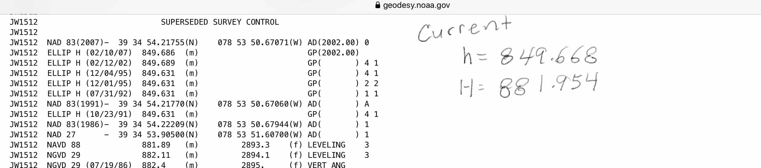
To supplement MightyMoe??s information, I copied segments of the NGS datasheet for a point in Maryland. Note that at the top of each datasheet is a section labeled ??Current Survey Control.? Below this section are short declarative statements about how each element was determined.
While the ellipsoid (h), NAVD orthometric (H) and the modeled ellipsoid-geoid separation (N) are related: h – H- N would ideally sum to zero, the datasheet elements are extracted from different portions of the NGS data base. In other words, in the images we see that the sum of the three published heights sum to 6.2 cm.
In the next image is shown the ??Superceded Survey Control? horizontal and vertical control point changes are tabulated here. Dates when the values were valid as well as the survey order and class of the determination should also be noted.
You will note that the sample point I used includes six (6) superceded ellipsoid heights. Note that the 1991 to 1995 heights show close agreement, as do the 2002 and 2007 superceded heights. The groupings differ however by over 5 cm. The ??current? ellipsoid height differs from the two most recent superceded ellipsoid heights by about 2 cm.
How can these differences be explained? One explanation for the shift between the 91-95 heights and the 2002-07 heights is the FBN survey undertaken to improve ellipsoid heights to a 2cm (local accuracy) standard. This survey was conducted in Maryland in 2000. I assume that the 2007 and 2011 nationwide adjustments (in 2007 and 2011) account for the most recent superceded and the current ellipsoid heights.
There is a file https://www.ngs.noaa.gov/DATASHEET/dsdata.pdf that explains better than I all the data element characteristics.
Also it is sometimes useful to examine the projects in which an NGS-published point participated. See: https://www.ngs.noaa.gov/cgi-bin/SURV_ID/mark_sources.prl
HTH, DMM
This has been a HARN point from the early days of GPS and it’s a prominent first order bench mark along with being an old first order Triangular station with R.M.s and an AZ mark, so it’s been occupied on a weekly basis by GPS users and of course files have been submitted to the NGS for the bench mark program.
I’ve seen units set up on one of the R.M.s, I didn’t stop and chat with anyone, I figure they knew what they were doing.
Of course the older ellipsoid heights have to be meshed to older Geoid heights to compare how close an elevation was for the earlier Epochs. 83/93 ellipsoid heights “corrected” by the Geoid 90 would give what at that time was the ortho height for the point using GPS, as I recall it was something like .3′ off the actual NAVD 88 elevation.
- Posted by: @mightymoe
I’ve seen units set up on one of the R.M.s, I didn’t stop and chat with anyone, I figure they knew what they were doing.
Or learned a lesson when things didn’t match up later.
.

Log in to reply.