
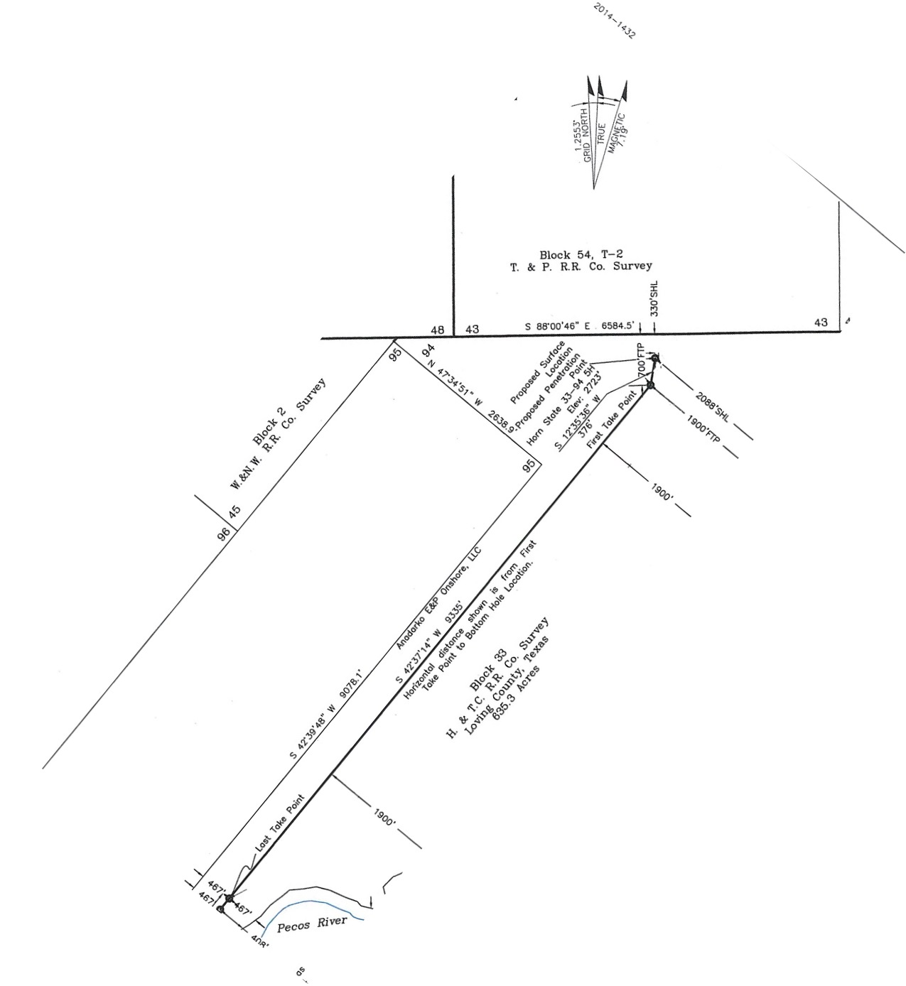
Unrecorded Plat H&TC Block 33
A little background. Who am I kidding? A lot of background. Maybe too much.
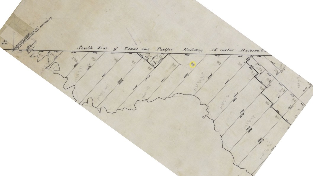
Section 94 of Block 33 was a “School Section” surveyed for the State of Texas by the Houston and Texas Central Railway Company on April 3rd, 1873 by Michael J. Doyle as Deputy Surveyor for Bexar Land District. Doyle was locating certificates along the Pecos River and ignored the Memphis, El Paso & Pacific Railway’s 16 mile reservation extending south of the New Mexico-Texas state line. Doyle continued locating his surveys to within a few miles of the state line.
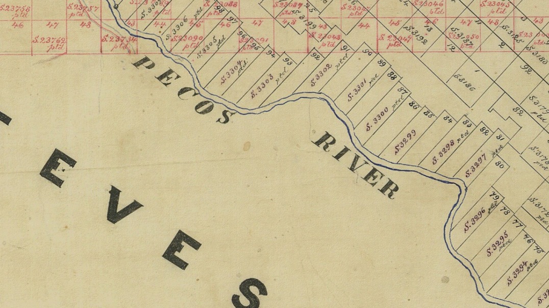
H&TC Surveys in Blue/Black, T&P in RedThe Texas & Pacific Railway was created by various Federal and State Acts of Congress and acquired the assets and rights of the Memphis, El Paso and Pacific Railway. The State of Texas affirmed the T&P Railway’s rights in an act passed May 2, 1873 and this portion of the 16 mile reservation in conflict with the previously located H&TC lands was surveyed for the T&P by W.B. Champlin and James L. Peck, Deputy Surveyors for the Texas and Pacific Railway Company, in August of 1876. Houston & Texas Central sued and lost the land to the Texas & Pacific as the reservation acquired from the Memphis, El Paso and Pacific Railway was held valid by the State Supreme Court on May 8, 1888.
Mayo William Neyland was sent out to resurvey Block 33 in August of 1888 and retraced the south line of the reservation as determined by the scant evidence he recovered from Champlin and Peck’s work.
Alex L. Adams applied to the land office to purchase School Section July 18, 1906 for $3.00 per acre and was awarded same on August 28th of that year. Neyland calculated the acreage of the revised Section 94 at 613 acres. I don’t quite understand the paper trail at this point, because a second and third application were submitted and the land was then apparently awarded to J.F. Henry on April 24, 1907. J.F. Henry sold the section to M.L. Henry on May 7, 1915, contingent on the assumption of the outstanding debt to the State of Texas.
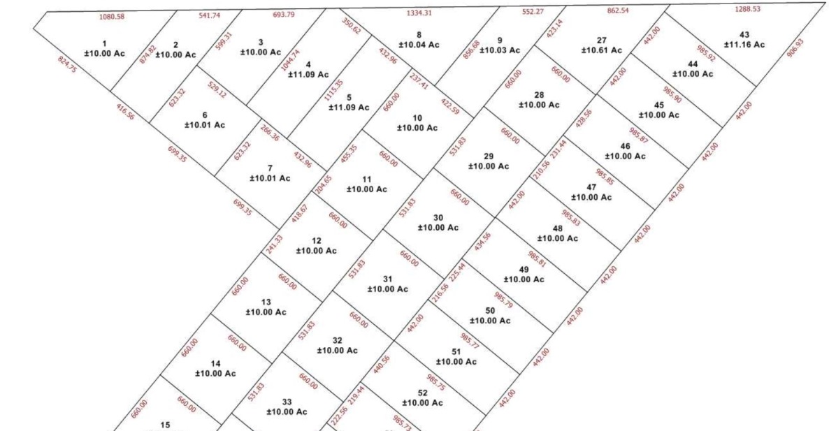
In April of 1920, M.L. Henry of San Angelo divided the section into mostly 10 acre lots, a year prior to oil discovery in the County and 11 years before the county was organized. Loving had been designated for future organization in 1887, fraudently organized in 1893 and dissolved in 1897, being reattached to Reeves County (where the plat was filed). I am not aware of any evidence of any lot sales based on this plat.

M.L. Henry quitclaimed the land to M.B. Pritzer on Dec. 4, 1947.
By 1939, the General Land Office was sending interest delinquency notices to M.L. Henry.
On March 27, 1941, the section was forfeited to the state for nonpayment of interest.
On December 31, 1947, Mr. Pritzer’s attorney, J.P. Parris tried to pay the back interest on the section. The commissioner replied that the reinstatement was limited to 5 years. In 1948, Mr. Pitzer wrote a heartfelt 5 page defense of his right to reinstate. The commissioner rejected the appeal for reinstatement. In 1949, Pitzer asked for a refund of the interest payment $853.64 that the state was holding in escrow. The state said, what money? In January of 1950, Pitzer said, please check again. I have retained a lawyer in Midland but I do not wish to cause Attorney Parris any unpleasant feelings, but I have given him every opportunity to correct the matter. Commissioner said, what money? In March of 1950, Pitzer asked the Chief Clerk to double check the forfeiture of the section and asked for a reconsideration of reinstatement. The commission said that his office has no jurisdiction in regard to the reinstatement of the account.
In 2003, Jerry Patterson was elected Commissioner of the General Land Office. Part of his efforts included the buying and selling of land in Texas both as investments in premium land to sell for profit at a later time period and disposing of tracts seen as unnecessary to generate a little extra change for the State. The surface only of Section 94 was put to public auction and the lucky bidder was Internet Land dealer Tony Masarweh in February of 2006 for $91.11 per acre along with several other sections. Masarweh quickly sold Section 94 to another internet land company, Finance All LLC on April 17, 2006 using the 1888 corrected field notes for the property description in the attached Exhibit “A”.
The deeds being spun off by the internet land company call for the lot number, a +/-10.00 acre tract and then a legal description that has absolutely no resemblance to the 1920 plat. The bearings are all to the nearest degree and the only calls for monumentation are identical to the 1888 corrected field notes.
We have done a thorough survey of Section 94 and found numerous original corners, although most have been accessorized with a 2” pipe or a capped 1/2 inch iron rod over the years since 1888. We know the true shape and size of the Section on the ground and needless to say, it doesn’t quite match the 1888 corrected field notes. An acceptable amount of error for an 1888 resurvey, but not identical as you all would suspect.
Here’s where it gets fun. Near as I can tell, it appears that All Finance had Carto Remote Sensing (the now defunct GIS mapmakers from the San Antonio area) prepare a new plat which has yet, to my knowledge, to be filed in the public records. I began to suspect a plat existed and called the sales company to request a copy. They do not have one, all the records affiliated with that section are stored “somewhere else”. According to the tax records and our title research, the company still appears to own at least 80 acres in the section. I was able to track down a copy of the Carto map (for which I am very thankful) and I plan to file a copy of it with my documents when they are recorded at the county. I will also email a copy to the county clerk for their use.
Here’s the questions I am trying to resolve at this time.
1. If the land was forfeited to the State of Texas, is the 1920 subdivision plat still valid? I realize that the modern deeds do not refer to the 1920s plat, this is more of an unrelated question aside from the reconstruction issues I am faced with.
2. Is the unrecorded subdivision plat sufficient to establish intent of simultaneous conveyance? The deeds all refer to the Tract Numbers and the courses and distances listed in the property description matches the unrecorded plat. I would think the lots would normally be reconstructed by Junior/Senior rights. There is a deficiency, so I’m trying to figure out the best way to reconstruct these Lots. Needless to say, there is no monumentation on the ground for the lot corners.Here’s an excerpt from a relevant post on the old RPLS.com titled “Texas land sold by GIS description on eBay” posted by Kent McMillan on Jan 13, 2006 11:27 pm: “…The ad on eBay claims that the deed to be delivered to the purchaser would describe the land by “GPS” coordinates so that no survey would be needed. Fascinated by the prospect of the mess that this scenario will spin off for future landowners and the hapless surveyor who may be eventually asked to mark some of the tract boundaries…”
Just call me Hapless. It’s about the 5th time I’ve dealt with internet land tracts and Carto maps in the last 12 months.
Log in to reply.