My first impression of Topcon's MAGNET Field Site software running on the Topcon FC-5000 controller wasn't a good one. I thought the controller was too big, the pop up keyboard a pain, and the lack of a tactile alphanumeric keyboard an egregious oversight. I thought the software was too simplistic. Time changes opinions. When operating the total station, I hold the controller in a vertical position. I programmed the F1 key to toggle screen rotation on/off. Although the pop up keyboard often blocks input fields, I discovered how to undock it. I favor using my finger over a stylus for input. It's more convenient. The map view is great for topo! While surveying in a wetland, it was great to see where the shots were taken. To edit my last point I have to scroll all the way down to the bottom of the point list. Why can't there be a "LAST" button like there is on the raw data screen? My biggest complaint is not knowing what my available point numbers are and what my last used point number was. I like numbering my traverse points 1 through 99. Topo points 1000 and up. There's plenty of room on the topo screen to display point information. It would be great to be able to customize the pop up keyboard to display only those keys I use in order to reduce screen clutter.
Field Dog, post: 387309, member: 9186 wrote: My first impression of Topcon's MAGNET Field Site software running on the Topcon FC-5000 controller wasn't a good one. I thought the controller was too big, the pop up keyboard a pain, and the lack of a tactile alphanumeric keyboard an egregious oversight. I thought the software was too simplistic. Time changes opinions. When operating the total station, I hold the controller in a vertical position. I programmed the F1 key to toggle screen rotation on/off. Although the pop up keyboard often blocks input fields, I discovered how to undock it. I favor using my finger over a stylus for input. It's more convenient. The map view is great for topo! While surveying in a wetland, it was great to see where the shots were taken. To edit my last point I have to scroll all the way down to the bottom of the point list. Why can't there be a "LAST" button like there is on the raw data screen? My biggest complaint is not knowing what my available point numbers are and what my last used point number was. I like numbering my traverse points 1 through 99. Topo points 1000 and up. There's plenty of room on the topo screen to display point information. It would be great to be able to customize the pop up keyboard to display only those keys I use in order to reduce screen clutter.
If you are getting a nagging pop-up keyboard then the FC5000 may be configured incorrectly.
Click on the Windows 10 task button, then toggle OFF the Tablet Mode. Now you will get the Topcon Magnet keyboard only when prompted. I don't use Magnet with a total station, so can't comment on that. But I really like it for GNSS, Robotics, and Digital Level.
FYI: I will be back in Orlando in October.
I like to see when surveyors win.
To me, anytime a mfr. comes out with a new product, with any new feature, that is good, it burdens the other mfrs. to provide it too. This "ups the ante" for surveying products. Case in point, Javad introduced the ability to take shots with a tilted pole. Well, now that is becoming available from Trimble, and maybe others. Often, when this happens, the 1st. Mfr to do it "breaks new teritory". Then, others that follow, try to "do it better". I'm always curious with each of these events, what it is that "is better". And, ultimately, the surveyors are the winners. I expect this general trend to continue, "til the end of time".
"Surveyors win" is good.
Let us know what magnet has, that others don't.
N
Nate The Surveyor, post: 387359, member: 291 wrote: I like to see when surveyors win.
To me, anytime a mfr. comes out with a new product, with any new feature, that is good, it burdens the other mfrs. to provide it too. This "ups the ante" for surveying products. Case in point, Javad introduced the ability to take shots with a tilted pole. Well, now that is becoming available from Trimble, and maybe others. Often, when this happens, the 1st. Mfr to do it "breaks new teritory". Then, others that follow, try to "do it better". I'm always curious with each of these events, what it is that "is better". And, ultimately, the surveyors are the winners. I expect this general trend to continue, "til the end of time".
"Surveyors win" is good.
Let us know what magnet has, that others don't.
N
Nate,
I am an end user, like you. I get to play with only the equipment I can purchase. I own all Topcon gear, so I can't comment on what Topcon has and others don't. I also like how new technology that may start with a single brand, then implemented by the other, whom try to improve upon it. I know Topcon has a mmGPS which increases the vertical accuracy on GNSS that which is equivalent or better than trig leveling. I wonder what other vendors have that compares to this.
Many Surveyor's have brand loyalty to their equipment, which may make them biased, just as with automobiles.
Field Dog, post: 387309, member: 9186 wrote: My first impression of Topcon's MAGNET Field Site software running on the Topcon FC-5000 controller wasn't a good one. I thought the controller was too big, the pop up keyboard a pain, and the lack of a tactile alphanumeric keyboard an egregious oversight. I thought the software was too simplistic. Time changes opinions. When operating the total station, I hold the controller in a vertical position. I programmed the F1 key to toggle screen rotation on/off. Although the pop up keyboard often blocks input fields, I discovered how to undock it. I favor using my finger over a stylus for input. It's more convenient. The map view is great for topo! While surveying in a wetland, it was great to see where the shots were taken. To edit my last point I have to scroll all the way down to the bottom of the point list. Why can't there be a "LAST" button like there is on the raw data screen? My biggest complaint is not knowing what my available point numbers are and what my last used point number was. I like numbering my traverse points 1 through 99. Topo points 1000 and up. There's plenty of room on the topo screen to display point information. It would be great to be able to customize the pop up keyboard to display only those keys I use in order to reduce screen clutter.
Dog-
One of the features in Magnet Field that may help eliminate or perhaps reduce the need for the keypad is Quick Codes- you can load different versions of quick code sets to appear translucently over the topo screen. Let's say you are shooting topo and there are six codes you will use a lot- these can be display as see through boxes on top of your work- you can have various groups made ahead of time to accompany the task at hand- cross section - utilities etc.
>>>"Field Dog, posted... To edit my last point I have to scroll all the way down to the bottom of the point list. Why can't there be a "LAST" button like there is on the raw data screen? My biggest complaint is not knowing what my available point numbers are and what my last used point number was.<<<<
Actually these do exist in Magnet. There are a lot of hidden features in Magnet.
To find your last point number go to Job >Job Info
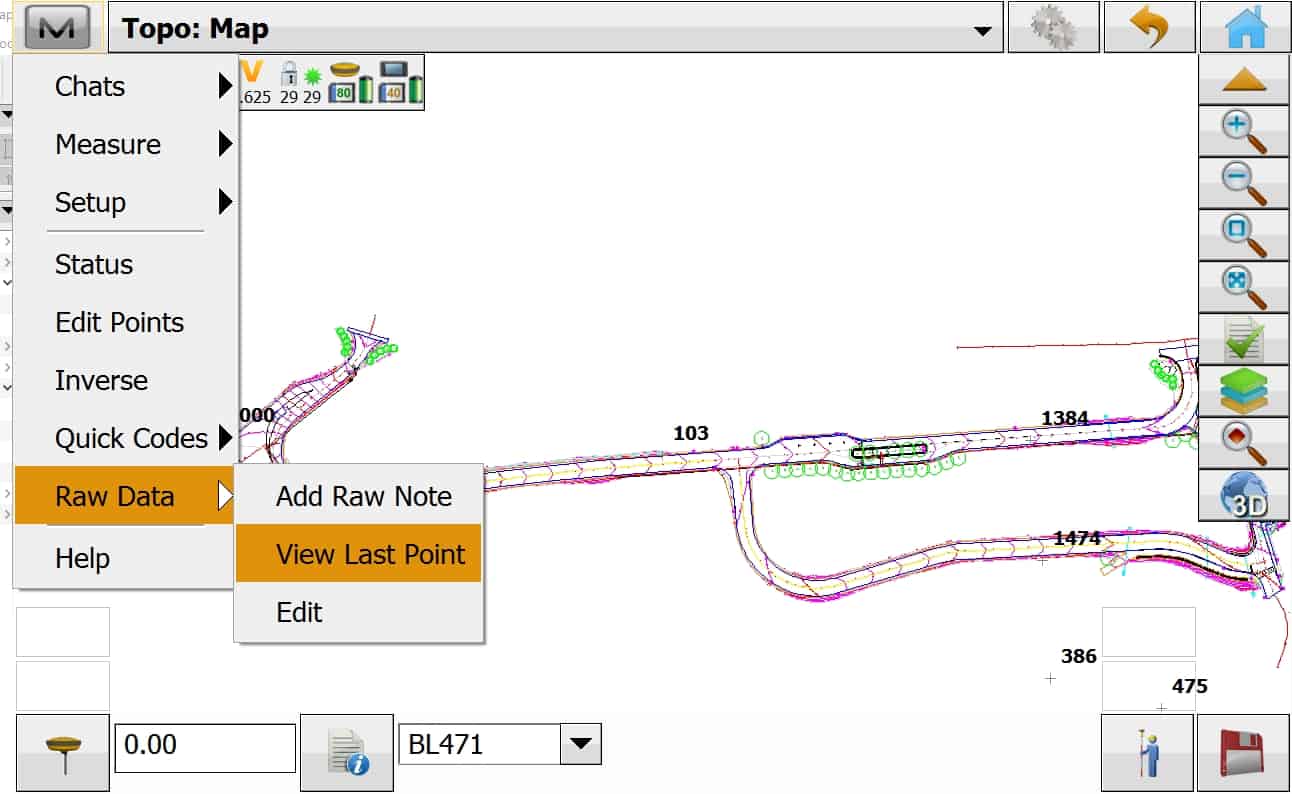
Also try clicking on the M "Magnet Logo" in upper left of the Topo ot Stake Stake screens. You will see options for Raw Data >Edit or View Last Point like shown below.
leegreen, post: 387757, member: 2332 wrote: >>>"Field Dog, posted... To edit my last point I have to scroll all the way down to the bottom of the point list. Why can't there be a "LAST" button like there is on the raw data screen? My biggest complaint is not knowing what my available point numbers are and what my last used point number was.<<<<
Actually these do exist in Magnet. There are a lot of hidden features in Magnet.
To find your last point number go to Job >Job Info
Also try clicking on the M "Magnet Logo" in upper left of the Topo ot Stake Stake screens. You will see options for Raw Data >Edit or View Last Point like shown below.
Hi Leegree, I am just curious about your workflow. You use magnet field for field with all the linework in and later in office do you export all of it to autocad straight or what?
Currently, I have switched over to Magnet Field and I am using Carlson F2F for my topos. My points I picked up are just X's on the screen which I just used for reference. Was wondering is it worth configuring the point codes to show lines as well as for my F2F?
sireath, post: 387816, member: 9370 wrote: Hi Leegree, I am just curious about your workflow. You use magnet field for field with all the linework in and later in office do you export all of it to autocad straight or what?
Currently, I have switched over to Magnet Field and I am using Carlson F2F for my topos. My points I picked up are just X's on the screen which I just used for reference. Was wondering is it worth configuring the point codes to show lines as well as for my F2F?
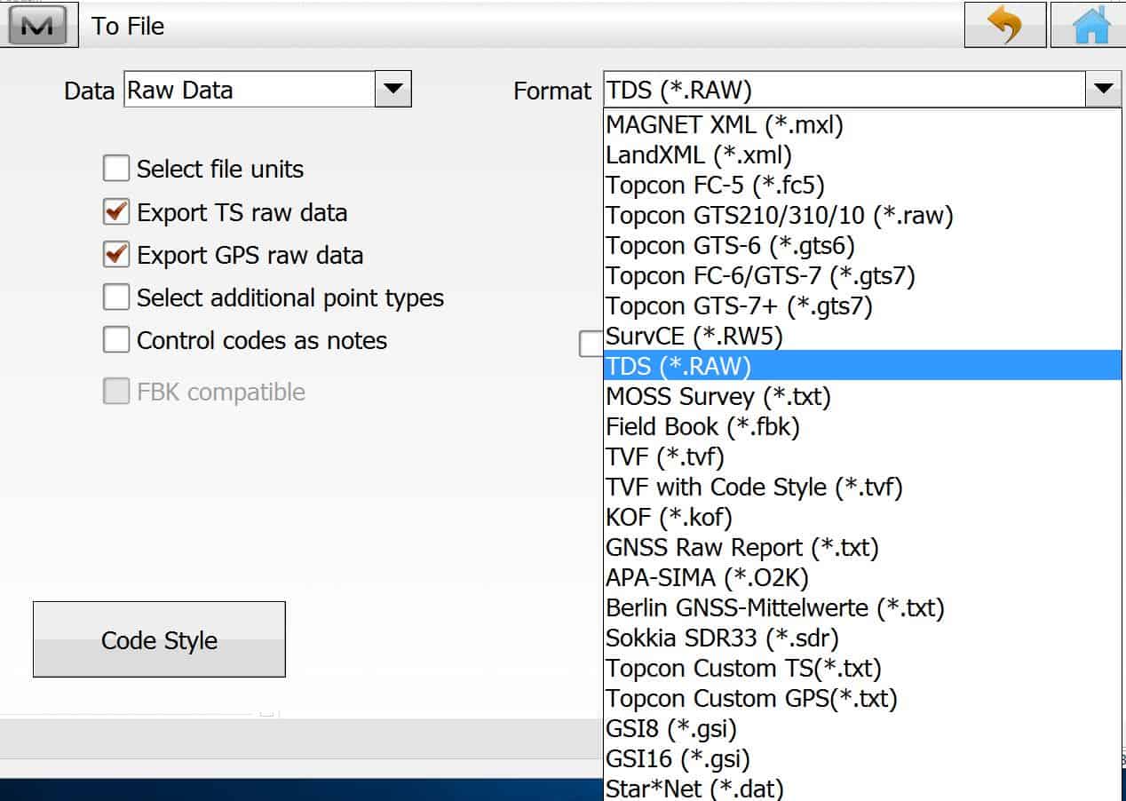
I do use the line codes in Magnet to draw the polylines in real time. This way the prism pole is my pencil. Also I like to generate contours in the filed before leaving the project. My feature codes in Magnet match those of my Microstation/InRoads for NYSDOT. I then export a RAW file from Magnet field and let Microstation and InRoads create the final DTM and DGN.
I recently purchased it with the new mesa fieldbook. I'm on 4.0 and have found a few bugs which i've transfered to topcon. What i miss the most is the lack off drawing features (circles,...) in the map window. I haven't tested everything though. Been a survce user. Does the office software add great value?
beuckie, post: 387831, member: 2245 wrote: I'm on 4.0 and have found a few bugs which i've transfered to topcon.
Did you get any update of fix to these bugs? My experience with Topsurv was that they are ignored.
The few bug's I found in version 4.0, were corrected in version 4.1
One problem still in Magnet Field 4.1, that I notice.
When importing Microstation DGN's, it assumes the units are metric. So you will need to change units from US Feet, to metric in Microstation, before importing the DGN into Magnet. Same problem exists with Geo TIF, and JPG image file, all world files are assumed to be in metric.
leegreen, post: 387824, member: 2332 wrote: I do use the line codes in Magnet to draw the polylines in real time. This way the prism pole is my pencil. Also I like to generate contours in the filed before leaving the project. My feature codes in Magnet match those of my Microstation/InRoads for NYSDOT. I then export a RAW file from Magnet field and let Microstation and InRoads create the final DTM and DGN.
please expand on letting mstn create the dgn from RAW. is RAW a msj file or a coordinate file or something else?
How about Bentley Open Roads?
linebender, post: 387953, member: 449 wrote: How about Bentley Open Roads?
Yes sir, Bentley OpensRoads and old product named SurveySelectCAD are compatible.
Bentley has so many products that do nearly the same thing, I can't keep track of them all.
leegreen, post: 387955, member: 2332 wrote: Yes sir, Bentley OpensRoads and old product named SurveySelectCAD are compatible.
Bentley has so many products that do nearly the same thing, I can't keep track of them all.
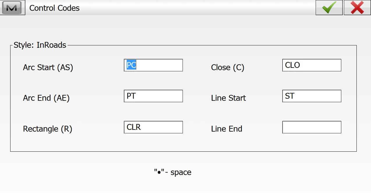
Ok How do you handle geometry codes ie begin line, end line, on curve, close figure etc so that OpenRoads handles it.
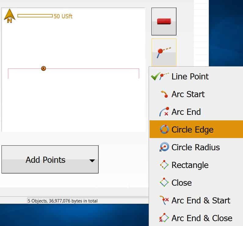
beuckie, post: 387831, member: 2245 wrote: I recently purchased it with the new mesa fieldbook. I'm on 4.0 and have found a few bugs which i've transfered to topcon. What i miss the most is the lack off drawing features (circles,...) in the map window. I haven't tested everything though. Been a survce user. Does the office software add great value?
What type of circles do you need to create. Magnet Field has a few hidden options.
Most people only use about 15% of what a software has to offer. I enjoy learning how to use the other 85%.
sireath, post: 387816, member: 9370 wrote: Hi Leegree, I am just curious about your workflow. You use magnet field for field with all the linework in and later in office do you export all of it to autocad straight or what?
Currently, I have switched over to Magnet Field and I am using Carlson F2F for my topos. My points I picked up are just X's on the screen which I just used for reference. Was wondering is it worth configuring the point codes to show lines as well as for my F2F?
We use ACAD for F2F, it works well. We used to use Carlson (we use SurvCE), but now go straight to ACAD.


