-
Gap/Title issue
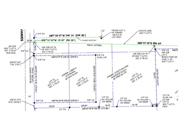
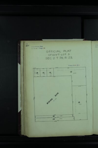
I am working on an ALTA, and the legal description is essentially all of Gov’t Lot 4 with a few excepted out parcels. The problem exception is based on a deed dimension of “58′ north of the NW corner of lot 16 of gov’t lot 5”. The NW corner of lot 16 is also intended to the SW corner of Gov’t Lot 4/NW corner of Gov’t Lot 5 The subdivision of Lot 5 created multiple additional lots to fill in the space between an existing subdivision within Lot 5 and the north line of Gov’t Lot 5/south line of Gov’t Lot 4. I found the monumented south line of Lot 4 and the NW cor. of lot 16, which there is a 42′ discrepency. The NW cor of lot 16 was established by platted distance up from a road within the Lot 5 subdivision. The road itself runs Ne’ly and the Gov’t Lot line runs SE’ly so there is an apparent sliver gap based on the platted dimensions. That distance error is also a nearly perfect amount of proof that the plat dimensions were transposed. (3.07 chains recorded, I measured 3.704 chains). I’m fighting with the sellers attorney because I’m holding the south line of Gov’t Lot 4 because it matches the angled line of the GLO survey and an old fence farther east than where the problem is at. This changed the deed dimension from 58′ to 16′. Meaning they are losing the additional 42′ of N/S road frontage that they’ve been occupying. I have told the attorney my defense of the south line as monumented and explained that distance discrepancies happen all the time, however he is still pushing to move the line 42′ south based on the occupation, which would theoretically create a new ‘SW corner of Gov’t Lot 4’ in the face of previously established and reaffirmed monument. I told the attorney I am of the opinion a judge will have to decide that line based on likely acquiescence, maybe adverse possession, because you only have title to Lot 4 and the title exception still physically lies within Lot 4, just a bad commencing distance. Any additional thoughts are appreciated.
Log in to reply.

